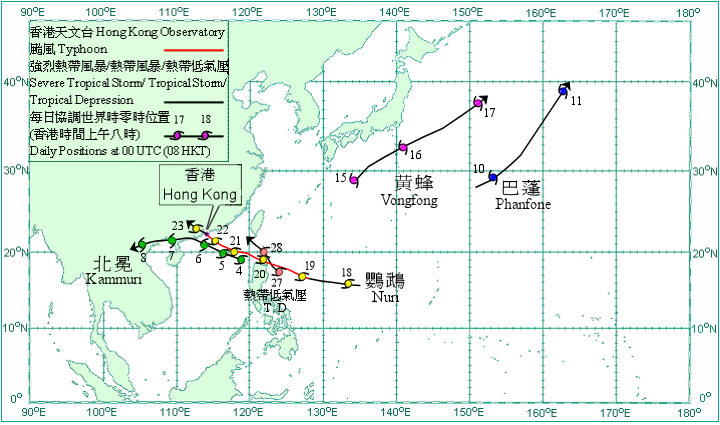
Overview of Tropical Cyclones in August 2008
Overview of Tropical Cyclones in August 2008
(Tracks)
|
Five tropical cyclones occurred over the western North Pacific and South China Sea in August 2008. Amongst them, Kammuri and Nuri necessitated the issuance of the Gale or Storm Signal No. 8 and the Increasing Gale or Storm Signal No. 9 in Hong Kong respectively. Kammuri formed as a tropical depression over the South China Sea about 580 km southeast of Hong Kong on 4 August and moved west-northwestwards. It intensified into a tropical storm the next morning. On the small hours of 6 August, Kammuri intensified into a severe tropical storm and moved northwestwards. It turned to move westwards later that afternoon and made landfall at Yangxi County in western Guangdong that evening, and weakened into a tropical storm that night. Kammuri weakened into a tropical depression over northern Vietnam on the small hours of 8 August and further into an area of low pressure there that morning. Phanfone formed as a tropical depression over the western North Pacific about 1 320 km southeast of Tokyo on 10 August and moved east-northeastwards. It intensified into a tropical storm that afternoon. Phanfone turned to move northeastwards and became an extra-tropical cyclone over the western North Pacific to the east of Japan on 11 August. Vongfong formed as a tropical depression over the western North Pacific about 660 km south of Osaka on 15 August and moved northeastwards. It intensified into a tropical storm that day and turned to move east-northeastwards the next day. It finally became an extra-tropical cyclone over the western North Pacific to the east of Japan on 17 August. Nuri formed as a tropical depression over the western North Pacific about 2 500 km east-southeast of Hong Kong on the evening of 17 August and moved westwards. It intensified first into a tropical storm and then a severe tropical storm the next day, and further into a typhoon and moved west-northwestwards on 19 August. Nuri entered the South China Sea on the evening of 20 August and turned to move northwestwards on the next evening. Nuri weakened into a severe tropical storm and crossed Hong Kong after making landfall at Sai Kung, Hong Kong on the afternoon of 22 August. Nuri crossed western Shenzhen and then made a second landfall near Nansha that night. It weakened first into a tropical storm on 23 August and a tropical depression that morning. Nuri further weakened into an area of low pressure over Guangdong subsequently. A tropical depression formed over the western North Pacific about 450 km northeast of Manila on 27 August and moved generally northwestwards. The tropical depression skirted the northeastern tip of Luzon that evening and crossed the Luzon Strait the next day. It weakened into an area of low pressure over the Luzon Strait to the south of Taiwan on 29 August.
|
