Overview of Tropical Cyclones in November 2007
|
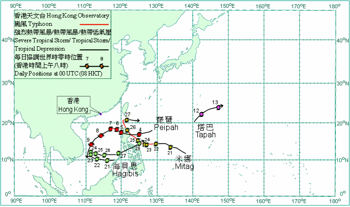
Overview of Tropical Cyclones in November 2007 Four tropical cyclones occurred over the western North Pacific and South China Sea in November 2007. Peipah formed as a tropical depression over the western North Pacific about 890 km east-northeast of Manila on 3 November and moved west-southwestwards. It intensified into a tropical storm on the early morning of 4 November and then a severe tropical storm that afternoon. After crossing Luzon on a west-northwest track that night, Peipah entered the South China Sea on the morning of 5 November and slowed down. It turned northwestwards that night and then intensified into a typhoon the next day. Under the combined effect of Peipah and the northeast monsoon, it was rather windy over the northern part of the South China Sea. Peipah turned to move southwestwards on 7 November. It weakened into a severe tropical storm that afternoon and then into a tropical storm that evening. After weakening into a tropical depression on the morning of 9 November, Peipah dissipated over the coastal waters of Vietnam that evening. Peipah caused seven deaths in the Philippines and left 600 000 people without electricity there. Tapah formed as a tropical depression over the western North Pacific about 510 km south of Iwo Jima on 11 November and moved generally northeastwards. It intensified into a tropical storm on 12 November and turned to move east-northeastwards that afternoon. Tapah weakened into a tropical depression and then became an extra-tropical cyclone over the western North Pacific to the east of Iwo Jima on 13 November. Hagibis formed as a tropical depression over the central part of the South China Sea about 400 km east of Nansha on 20 November and moved westwards. It intensified into a tropical storm on the morning of 21 November and then into a severe tropical storm that night. Hagibis slowed down on 23 November and turned to move eastwards the next day. It weakened into a tropical storm on 26 November. After crossing the central Philippines on 27 November on an east-northeasterly track, Hagibis weakened into a tropical depression on the early morning of 28 November and then into an area of low pressure over the western North Pacific that day. In the Philippines, 14 people were killed under the influence of Hagibis. A Philippine fishing boat capsized in the South China Sea and 25 crewmen were missing. Mitag formed as a tropical depression over the western North Pacific about 1 660 km east of Manila on 20 November and moved generally west-northwestwards. It intensified into a tropical storm the next morning. Mitag intensified into a severe tropical storm and then a typhoon on 22 November. It turned to move northwest on 24 November. After crossing Luzon on 26 November, Mitag turned to move north-northwest over the Luzon Strait that night. Mitag turned to move east on 27 November. It weakened gradually on that day into a severe tropical storm that morning, into a tropical storm that afternoon, and then into a tropical depression that night. Mitag weakened into an area of low pressure over the western North Pacific on 28 November. In the Philippines, eight people were killed and two reported missing. Around 1 000 hectares of rice crops were flooded.
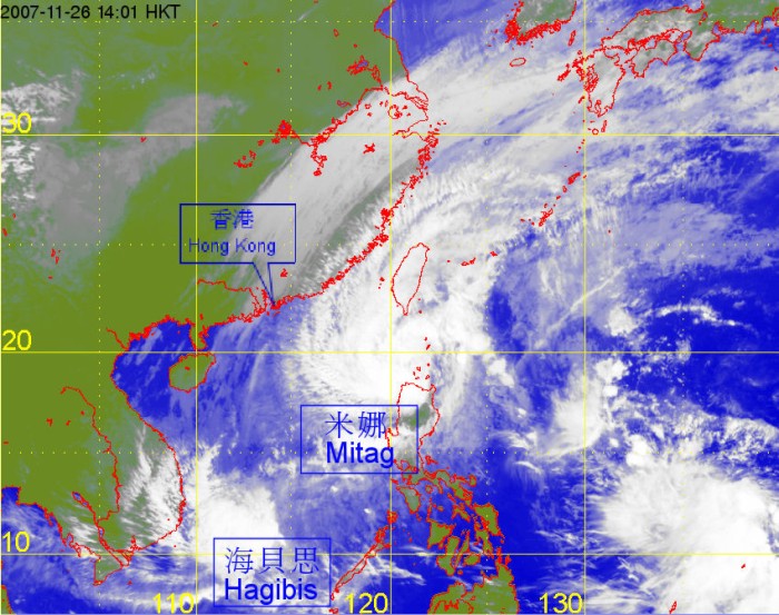
Satellite infra-red imagery at around 2 p.m. on 26 November 2007 of Mitag and Hagibis. |

