Overview of Tropical Cyclones in October 2007
|
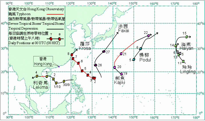
Overview of Tropical Cyclones in October 2007 Seven tropical cyclones occurred over the western North Pacific and South China Sea in October 2007. Amongst them, four of the tropical cyclones only affected the western North Pacific east of longitude 140. After forming over Luzon and entered into the South China Sea at the end of September, Lekima intensified into a severe tropical storm on 1 October over the central part of the South China Sea and moved northwestwards. Under the combined effect of the northeast monsoon and Lekima, windy conditions and rough seas affected the south China coastal waters. Lekima made landfall near Sanya, Hainan on the night of 2 October and skirted the southern part of Hainan. It intensified into a typhoon over Beibu Wan on 3 October. Lekima made landfall over the coast of Vietnam coast that evening and then weakened into a severe tropical storm. It continued to weaken into a tropical storm on the early morning of 4 October and a then a tropical depression that afternoon. Lekima dissipated inland that evening. In the fury of Lekima, more than 225 000 people had to be evacuated from low-lying areas and the direct economic losses amounted to 504 million yuan in Hainan. Lekima brought floods and landslides to Vietnam where at least 67 people were killed, over 70 000 houses were flooded or collapsed. Krosa developed as a tropical depression over the western North Pacific about 1 000 km south-southeast of Okinawa on 1 October and was almost stationary. It intensified into a tropical storm the next day. Krosa intensified first into a severe tropical storm and then into a typhoon on 3 October, and started to move northwestwards. It crossed the northern part of Taiwan on the night of 6 October. In the fury of Krosa, 5 people were killed, 2 missing and 56 people were injured in Taiwan. Electricity supplies to more than 2 million households were disrupted. Krosa crossed the Taiwan Strait on the morning of 7 October. It made landfall over the coast of southeast China between Cangnan, Zhejiang and Fuding, Fujian that afternoon and then weakened into a severe tropical storm and became slow moving. Krosa weakened into a tropical storm on the early morning of 8 October and then turned to move northeastwards. It weakened further into a tropical depression that afternoon. Krosa became an extra-tropical cyclone over the East China Sea that night. Krosa brought heavy rain and flooding to Zhejiang where seven million people were affected, electricity supply to 51 villages and towns was disrupted and the economic losses amounted to 7.5 billion yuan. Haiyan developed as a tropical depression over the western North Pacific about 1 080 km north-northeast of Wake Island on 5 October and moved generally west-northwestwards. It intensified into a tropical storm the next day and turned to move northwards. Haiyan dissipated over the sea after weakening into a tropical depression on 7 October. Podul formed as a tropical depression over the western North Pacific about 850 km east of Iwo Jima on 5 October and moved generally northeastwards. It intensified into a tropical storm the next day. Podul became an extra-tropical cyclone on 7 October over the western North Pacific east of Japan. Lingling formed as a tropical depression over the western North Pacific about 1 010 km east-northeast of Wake Island on 11 October and moved generally northwestwards. It intensified into a tropical storm the next day, and then turned to move north-northeastwards on 14 October. Lingling turned to move eastwards on 15 October and became an extra-tropical cyclone over the western North Pacific near the International Date Line. Kajiki formed as a tropical depression over the western North Pacific about 560 km north of Guam on 19 October and moved generally northwestwards. It intensified into a tropical storm that afternoon and a severe tropical storm that evening. Kajiki intensified further into a typhoon on 20 October and turned to move northwards. It accelerated towards northeast the following day. Kajiki weakened into a severe tropical storm on 22 October and then became an extra-tropical cyclone over the western North Pacific. Faxai developed as a tropical depression over the western North Pacific about 1 220 km southeast of Okinawa on 25 October and moved north-northwestwards. It intensified into a tropical storm the next day and turned to move northeastwards. Faxai intensified further into a severe tropical storm on 27 October and passed to the east of Japan that evening. It became an extra-tropical cyclone over the western North Pacific to the east of Japan on 28 October.
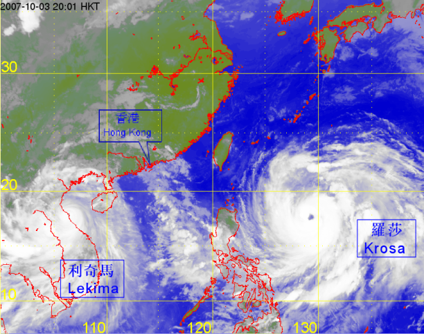
Satellite infra-red imagery at around 8 p.m. on 3 October 2007 of Lekima and Krosa. |

