Overview of Tropical Cyclones in September 2007
|
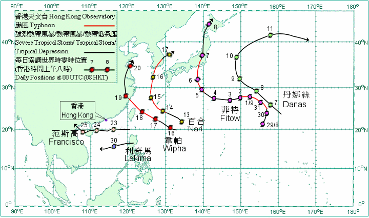
Overview of Tropical Cyclones in September 2007 Six tropical cyclones occurred over the western North Pacific and South China Sea in September 2007. Amongst them, Tropical Storm Francisco necessitated the issuance of tropical cyclone warning signals in Hong Kong for the second time this year. After forming over the western North Pacific last month, Typhoon Fitow turned to a westerly track when it was to the east of Ogasawara Islands on 1 September. Fitow weakened into a severe tropical storm on 2 September but re-intensified into a typhoon on 5 September. It turned north and crossed the eastern part of Honshu, Japan on 6 September. Fitow weakened into a severe tropical storm on 7 September. It weakened further into a tropical storm early next morning, and then became an extra-tropical cyclone near Hokkaido, Japan during the day of the same day. Danas formed as a tropical depression over the western North Pacific about 1 950 km east of Iwo Jima on 6 September and moved northwestwards. It intensified into a tropical storm the next day and turned to move north-northwest on 9 September. Danas intensified further into a severe tropical storm on 10 September and changed to move northeastwards. It turned to move east and became an extra-tropical cyclone over the western North Pacific to the east of Japan on 11 September. Nari developed as a tropical depression over the western North Pacific about 820 km southeast of Okinawa on 13 September and moved west-northwestwards. Nari intensified into a tropical storm that afternoon. It further intensified first into a severe tropical storm and then a typhoon on 14 September, and passed to the southwest of Okinawa that evening. Nari turned to move north on 15 September. It crossed the southeastern part of Korea and weakened into a severe tropical storm the next evening. Nari turned to move northeastwards and became an extra-tropical cyclone over the Sea of Japan on 17 September. Nari brought heavy rain to Korea, causing floods and landslides. At least 13 people were killed and 7 others missing. In Jeju, over 30 vessels sank or were wrecked. Electricity supply to over 50 000 households was interrupted. Wipha developed as a tropical depression over the western North Pacific about 880 km southeast of Okinawa on 15 September and moved west-northwestwards. It intensified first into a tropical storm and then a severe tropical storm the next day. Wipha intensified further into a typhoon on 17 September. It turned to move northwest on 18 September and passed to the north of Taiwan that evening. Under the fury of Wipha, one person was killed in Taiwan while another injured. Electricity supply to about 8 000 families was interrupted. Wipha made landfall near Cangnan, Zhejiang on the early morning of 19 September. It weakened into a severe tropical storm and turned to move northwards that morning, and weakened further into a tropical storm that afternoon. Wipha became an extra-tropical cyclone over the Yellow Sea on 20 September. Wipha brought severe damage to Zhejiang, Fujian and Jiangsu. At least 5 persons were killed and 3 others injured. Over 2.68 million people had to be evacuated. Over 9 600 houses collapsed and another 42 000 houses were damaged. The direct economic losses amounted to 6.6 billion yuan. Francisco developed as a tropical depression over the South China Sea about 700 km east-southeast of Hong Kong on 22 September. It moved westwards and intensified into a tropical storm on the afternoon of 23 September. Francisco passed about 290 km to the south-southwest of Hong Kong on the early morning of 24 September and made landfall over Hainan that afternoon. Francisco weakened into a tropical depression and crossed Beibu Wan on 25 September. It made landfall and weakened into an area of low pressure over the coastal regions of northern Vietnam on the early morning of 26 September. Lekima developed as a tropical depression over Luzon about 220 km north-northeast of Manila on 29 September. It moved westwards and entered the South China Sea that evening. Lekima changed to move west-southwestwards and intensified into a tropical storm on the last day of the month.
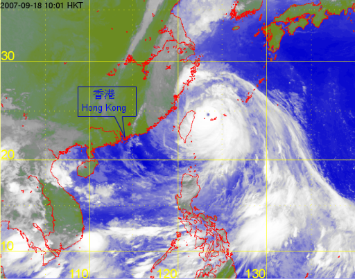
Satellite infra-red imagery at around 10 a.m. on 18 September 2007 of Typhoon Wipha. |

