Overview of Tropical Cyclones in August 2007
Overview of Tropical Cyclones in August 2007
(Tracks)
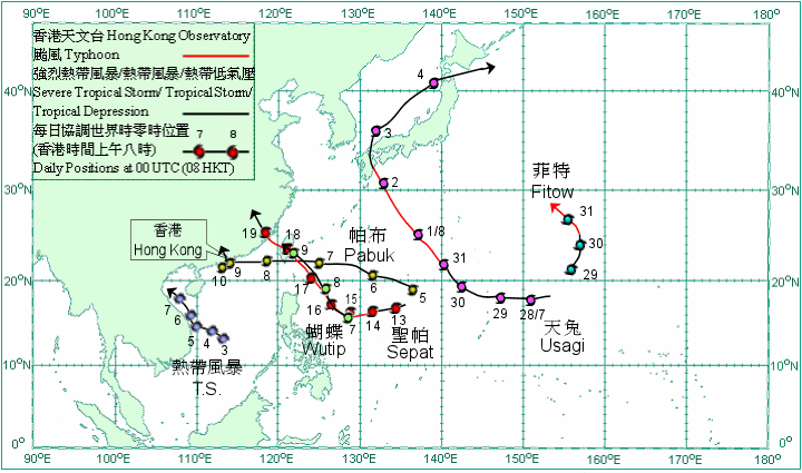
Six tropical cyclones occurred over the western North Pacific and South China Sea in August 2007. Amongst them, Pabuk necessitated the issuance of the first tropical cyclone warning signal in Hong Kong in the year.
After forming over the western North Pacific last month, Typhoon Usagi continued to move northwestwards towards Japan on 1 August. It made landfall over Kyushu, Japan on 2 August. Usagi weakened into a severe tropical storm that evening and turned to move north-northeastwards to cross the western part of Honshu, Japan on the early morning of 3 August. It weakened further into a tropical storm in that morning and became an extra-tropical depression on the evening of 4 August over the western North Pacific to the southeast of Hokkaido, Japan. In the fury of Usagi, at least five people were injured and about 9 700 homes were without power supply in Japan.
A tropical depression formed over the central part of the South China Sea about 420 km south-southeast of Xisha on the morning of 3 August and moved generally west-northwestwards. It intensified into a tropical storm the next morning and took on a north-northwesterly track on 5 August, skirting the coast of Vietnam. It weakened into a tropical depression on 6 August and further into an area of low pressure south of Beibu Wan on 7 August.
Pabuk formed as a tropical depression over the western North Pacific about 1 220 km southeast of Okinawa on 5 August and moved generally west-northwestwards. It intensified into a tropical storm that evening and became a severe tropical storm the next day. Pabuk crossed the southern tip of Taiwan on the early morning of 8 August, and weakened into a tropical storm that afternoon. Pabuk skirted the seas south of Hong Kong on 9 August and weakened into a tropical depression. It turned northeastwards and intensified into a tropical storm on 10 August. Pabuk crossed the western part of Hong Kong in that afternoon but turned abruptly westwards to make landfall in Zhongshan in that evening and weakened into a tropical depression. It weakened into an area of low pressure inland on 11 August.
Wutip formed as a tropical depression over the western North Pacific about 820 km east of Manila on 7 August. Wutip moved northwestwards and intensified into a tropical storm the next day. It weakened into a tropical depression and crossed Taiwan on the morning of 9 August. Wutip weakened further into an area of low pressure over Taiwan that day.
Sepat formed as a tropical depression over the western North Pacific about 1 600 km east of Manila on 12 August and moved generally west-southwestwards. It intensified first into a tropical storm and then a severe tropical storm the next day. Sepat became a typhoon on 14 August and changed to a northwesterly track on 15 August. After moving across Taiwan on 18 August, Sepat made landfall near Quanzhou City, Fujian on the morning of 19 August and weakened into a tropical storm. It weakened into a tropical depression that night and further into an area of low pressure over southeastern China on 20 August. During the passage of Sepat over Taiwan, one person was killed and 24 people injured, electricity supply to more than 300 000 households were disrupted and the damage to fisheries and agriculture amounted to about HK$200 million. In Fujian and Zhejiang, a total of 14 people were killed, one person was missing and over 60 people injured. Over 3 300 houses collapsed and the economic losses exceeded RMB$1 900 million.
Fitow formed as a tropical depression over the western Pacific about 1 310 km east-northeast of Guam on 29 August. It moved northeastwards initially and intensified rapidly into a severe tropical storm that evening. Fitow intensified into a typhoon on 30 August and turned to a northerly track. It changed further to a northwesterly track on the last day of the month.

Tracks of tropical cyclones in August 2007

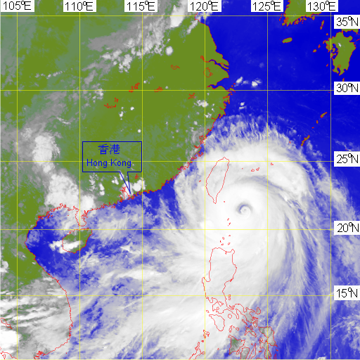
Infra-red imagery at around 5 p.m. on 17 August 2007 of Typhoon Sepat.
[The satellite imagery was originally captured by Multi-functional Transport Satellite-1R (MTSAT-1R) of Japan Meteorological Agency (JMA).]