Typhoon Wanda
Typhoon Wanda
August 27 to September 2, 1962
(extracted from the Observatory's publication
"Supplement to Meteorological Results 1962")
Wanda formed on August 27 as a tropical depression over the Pacific about 1300 miles to the east-southeast of Hong Kong. Moving west-northwest towards the Luzon Strait at fifteen knots it gradually intensified and by the next day was a severe tropical storm. (The track of Typhoon "WANDA" is shown in Fig.I)
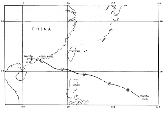 |
| Fig. I. The track of typhoon Wanda. The circles show the positions at 0000 G.M.T. on the date in the circle. |
On August 29 a U.S.A.F. reconnaissance aircraft flew into the eye of the storm and report that the wind strength had reached hurricane force. By this time the circulation of the typhoon covered a wide area about 1000 miles across.
Another aircraft reconnaissance on August 30 indicated that further intensification had occurred and 80 knot winds were reported near the centre. It continued to move towards Hong Kong and by the evening it was centred 400 miles east-southeast of the Colony, over the southern part of the Luzon Strait. No. 1 Local Storm Signal was hoisted at 7.45 p.m.
Up to this time the winds over the Colony had been generally light or moderate but early the next morning they set in from the north and showed signs of freshening. The No. 3 Local Storm Signal was hoisted at 4.10 p.m. on August 31.
The first rain came with a squall of north-northwest winds which moved west across the Colony during the early evening. By 9 a.m. typhoon "WANDA" was centred about 155 miles east-southeast of the Colony and was moving west or west-northwest at 10 knots. Although no strong winds had yet been reported it became certain that "WANDA" would pass close to the Colony the next day and No. 7 signal was hoisted at 10.50 p.m. The wind speed reached gale force with gusts to 48 knots at Waglan Island at 2.00 a.m. on September 1 when "WANDA" was centred about 105 miles away.
At 4.15 a.m. No. 9 Local Storm Signal was hoisted to indicate that the gales were expected to increase. By this time winds over the harbour were averaging about 30 knots from the north-northwest but Walgan Island was reporting 40 knots with gusts to 57 knots.
No. 10 Local Storm Signal was hoisted at 6.15 a.m. on September 1 when "WANDA" was centred some 50 miles away and moving directly towards the Colony. As the approach coincided with high tide, a warning was issued at 6.30 a.m. stating that the water would rise 6 feet above normal high tide in the harbour and much higher in Tolo Harbour with flooding over low-lying land.
By 9 a.m. typhoon "WANDA" was centred over the eastern waters of the Colony and hurricance force winds were blowing over most of Hong Kong. Gusts of 116 knots were reported from Waglan Island and 154 knots from Tate's Cairn.Fig. II is the anemogram from the Royal Observatory. It shows that the 10 minute mean wind reached typhoon force at about 9.20 a.m. and rose to a maximum of about 78 knots at about 9.30. a.m. It decreased slightly as the eye passed and then increased again to about 74 knots at 10.00 a.m. At about 9.30 a.m. a maximum gust of 140 knots was recorded at the Royal Observatory as the typhoon centre was passing south of Waglan Island.
The centre of typhoon "WANDA" passed about 10 miles south of the Royal Observatory at 9.50 a.m. still moving west-northwest at 11 knots. Tides in Tolo Harbour rose about 10 feet above the normal high tide of 17 feet above chart datum, while the crests of wind-driven waves at Tai Po Kau reached about 23 feet above chart datum. Altogether nearly 12 inches of rainfall were recorded at the Royal Observatory. At 11.30 a.m. the eye of "WANDA" passed very close to Cheung Chau and it was almost calm there for a while. With the typhoon passing close to the south there was a rapid veering of winds to southeast over the whole Colony and although there was a temporary lull in many places the wind strength increased again. At noon gusts of 82 knots were still being reported from WagIan Island and 80 knot gusts were registered at the Royal Observatory at 12.30 p.m. By this time the typhoon was centred close to Lantau and was moving away to the west at 12 knots. No.10 signal was replaced by No. 6 at 2.15 p.m. to indicate that the wind might veer to the southwest. Although gales were still blowing at Waglan Island and Cheung Chau up to 6 p.m. the wind over the harbour area had dropped below gale force by this time.
No. 3 signal replaced No. 6 Local Storm Signal at 7.05 p.m. and, as strong winds persisted, it could not be lowered until 12.45 a.m. on September 2 when all danger had passed. The typhoon moved inland over Kwangtung and weakened rapidly during the morning.
STRONGEST WINDS IN "WANDA" AND OTHER STORMS
This table shows the average wind speed in knots as recorded (uncorrected) at the Royal Observatory during each of the three hours before and the four hours after the maximum wind
| Date | AUG. 17 1936 |
SEPT. 2 1937 |
GLORIA SEPT. 22 1957 |
MARY JUNE 9 1960 |
ALICE MAY 19 1961 |
WANDA SEPT. 1 1962 | |
| Mean hourly wind speed | |||||||
| 3 hrs. before | Max. wind | 37 | 20 | 44 | 42 | 34 | 36 |
| 2 hrs. before | 46 | 30 | 49 | 44 | 38 | 45 | |
| 1 hr. before | 54 | 58 | 51 | 44 | 42 | 54 | |
| Maximum hourly mean wind | 62 | 59 | 59 | 50 | 43 | 68 | |
| 1 hr. after | Max. wind | 56 | 58 | 56 | 44 | 12 | 48 |
| 2 hrs. after | 52 | 43 | 46 | 36 | 14 | 40 | |
| 3 hrs. after | 29 | 34 | 37 | 37 | 39 | 36 | |
| 4 hrs. after | 24 | 29 | 36 | 45 | 42 | 33 | |
| Maximum gust (knots) | 115 | 130* | 101 | 103 | 89 | 140 | |
| Instantaneous Minimum Pressure (mb.) |
979.3 | 958.3 | 984.3 | 973.8 | 981.1 | 953.2 | |
*The piston of the anemometer hit the stops at 130 knots and the true maximum gust could not be recorded.
The table above indicates that "WANDA" was one of the most severe typhoons experienced in Hong Kong. Fig. III is the barogram from the Royal Observatory. The lowest pressure 953.2 mb. (28.15 inches of mercury) was a record low value and the maximum gust the highest recorded at the Observatory since 1911 when gust observations commenced. The mean hourly wind speed of 68 knots was the second highest on record and was only exceeded by one knot in 1896. At about the time of the maximum gust of 140 knots the wind speed averaged about 78 knots for a short period.
The following daily amounts of rainfall were recorded at the Royal Observatory during the passage of "WANDA" :
|
August 31 |
22.3 mm. (0.88 inches) |
|
September 1 |
203.0 mm. (7.99 inches) |
|
September 2 |
37.5 mm. (1.48 inches) |
A Brief Account of the Floods in Tolo Harbour Caused by Typhoon "WANDA"
Causes
The tides in Hong Kong normally consist of alternating large and small excursions. Each day there is normally one maximum high water averaging 7 feet, one secondary high water averaging 4.9 feet, one secondary low water averaging 4.0 feet and one minimum low water averaging 2.2 feet above chart datum.
On the 1st September 1962 the predicted maximum high water was to be 7.2 feet at 11.31 a.m. It was an unfortunate coincidence that typhoon "WANDA" should pass Hong Kong at about the same time.
The northerly typhoon winds blowing between 7 a.m. and 10 a.m. must have greatly assisted the incoming tide through the comparatively narrow Tolo Channel and also prevented any of the rapidly accumulating water from leaving. The effect of winds on tides is very complicated but it is generally accepted that in the Northern Hemisphere the water tends to pile up in a direction somewhat to the right of down wind. The entrance to Tolo Harbour is towards the southwest which would be about the right direction for maximum build up with northerly winds. Normal waves do not cause any net flow of water as the return flow near the bottom of the wave balances the forward flow near the surface. With very large waves in shallow water the return flow is partly cut off and a large net flow of water takes place.
The catchments around Tolo Harbour are notorious for the rapidity of the run off as previous reports of drownings in flash floods (e.g. August 1955) bear witness. However, Tolo Harbour covers an area at least as great as its immediate catchment and as the rainfall up to 10 a.m. was only about 4 inches the effect of rainfall on tide height in Tolo Harbour was probably less than 8 inches. With the approach of typhoon "WANDA" the typhoon force winds commenced to blow rather suddenly and an internal tidal wave developed. Tide gauge records show a series of at least seven maxima at intervals of approximately 3.75 hours, the second and by far the greatest of which occurred at about 10.30 a.m.
The atmospheric pressure near the centre of "WANDA" was sufficiently low to cause a static increase in sea level of about 1.5 ft. This would take the form of a dome of water possibly about 100 miles across. As this dome moved into shallower water near the coast it would be slowed down and its height would increase. In fact tide heights in the more open waters at North Point were already between 2 and 3 ft. above the predicted level, when the tide gauge ceased to function at about 9.30 a.m. The total effect appears to have been that the tide in Tolo Harbour rose approximately 10 ft. above the predicted 7'2". Wind driven waves probably contributed an additional 6 ft. on the downwind shore near Sha Tin.
In Sha Tin Village Police Post the high water mark was 17'3" above chart datum or 5' above road level. At the railway station high water was over the railway track but below the level of the platform. The water was reported to rise very quickly for 10 or 15 minutes, and the highest level lasted for 10 - 15 minutes some time between 10.30 and 11.30 a.m. At the aerodrome there were two high water marks both about 6 ft. above the level of the airstrip, which is 10 ft. above chart datum.
At Tai Po Fire Station high water was 16'7" above chart datum and at the Marine Licensing Office in Tai Po it stayed around 16'5" for about 0.5 hour commencing at 10.25 a.m.
At the Shell Installation at Tai Po Kau the level was 17'9" above chart datum and waves were reported as high as the fence round the installation approximately 23 ft. above chart datum.
Other high water marks included, the Resident Engineer's (Tunnel) Office at Sha Tin 17'7", the Tin Chui Tong Church 17'9" and the Railway Guard house at Sha Tin 17'7". All these heights are above chart datum and should be reduced by 0.48 ft. to give levels above the principal datum.
Comparison with 1937
Destructive tidal surges were reported in Tolo Harbour in 1874, 1906, 1923 and 1937 but only the latter is considered here. The Typhoon of 1937 occurred only one day later in the year on September 2. The centre passed about 7 miles south of the Royal Observatory at 4.30 a.m. compared with "WANDA" which passed 10 miles south of the Royal Observatory at 10.45 a.m. Tides in the harbour in 1937 were estimated to be 6 ft. above normal and the tidal wave in Tolo Harbour was reported to be about 30 ft. high. However there were no tide gauges in Tolo Harbour and the stationmaster at Sha Tin said that there was practically no difference between the two typhoons in the maximum heights reached at the Railway Station. It has been(i) estimated that the high water mark in Tai Po left by the 1937 typhoon was about 20 ft. 6 inches above chart datum.
The main difference between the two typhoons is that the 1937 typhoon occurred in darkness and the flooding was totally unexpected. Fatalities were estimated at 11,000 compared with 127 in "WANDA".
In "WANDA", the Royal Observatory issued a warning of possible flooding in Tolo Harbour at 6.30 a.m. and as a large number of people appear to have been listening to radios the warning was quite effective. The warning appears to have been more effective in Tai Po than in Sha Tin possibly because the local inhabitants did not associate Sha Tin with Tolo Harbour and also because in 1937 Sha Tin was very sparsely populated whereas some of the inhabitants of Tai Po probably remembered 1937.
As the flooding occurred in daylight many people could see the approaching waters and escape. However the sudden collapse of the sea wall of Sha Tin did not give them much time to remove their possessions. Many of the residents of the huts in the flooded areas had already left home when the flood occurred and the majority of the casualties appear to have occurred among the boat people.
Some Effects of Flooding
A total of 869 acres of farm land were flooded with sea water, 277 acres in Sha Tin, 314 acres at Tai Po and 278 acres at Sha Tau Kok. 179 acres of low lying farm mostly at Sha Tin were still affected two months later due to breached bunds. There was also some flooding in Happy Valley.
More than 300 fishing boats out of a total fleet of just over 1000 were wrecked in the Tolo Harbour area. The very high tides must have made mooring extremely difficult.
It is estimated that approximately 3000 huts and 5 village type houses were damaged or destroyed in Sha Tin. This is very roughly estimated to be about one fifth of this type of accommodation in Sha Tin. Many of the huts were destroyed by boats or logs crashing into them.
Possibly as a result of the monthly credit system, the shops in Sha Tin contained nearly a whole month's supply of rice for the village and this was destroyed.
Various roads which run near the sea were breached including the Ting Kok Road near Tai Po and the Lukkeng Road near Sha Tau Kok.The main Taipo Road and the railway were both effectively blocked with boats, flotsam and silt.
Damage due to Typhoon "WANDA"
Damage and casualties were widespread throughout the Colony. 130 people were killed and 53 were missing. Approximately 72,000 people were registered as being homeless. Of a total of 20,287 small craft in Colony waters, 726 were wrecked, 571 were sunk and 756 damaged. Of a total of 132 ocean-going ships, 24 were beached and 12 involved in collisions. The "Vinkon" and "Haijye" ran aground near the railway line at Tai Po Kau and on Harbour Island respectively. The "Cronulla" capsized near West Point and the "Tung Feng" sank near Green Island. Other ships sunk during typhoon "WANDA" included the "Yeni Meserret" the "Tai Kwong No. 1" and the tugs "Dorothy" and "Kowloon Docks".
The typhoon played havoc with field crops, fruits, vegetables and flowers in various districts of the New Territories. About 650 acres of paddy fields in the Tai Po, Sha Tin and Sha Tau Kok areas were inundated with sea water and the annual rice production was reduced by nearly 20% compared with 1961.
Late summer vegetables, particularly the climbing varieties were severely damaged. About 280 acres of vegetables were inundated with sea water.
Damage to trees and forest plantations was severe. Many trees were uprooted or snapped off and many more had all leaves and small branches stripped off so that only bare trunks remained.
The main fruits in season were banana and papaya and these sustained serious damage. All citrus and olives were in the bearing stage and were partly spoiled. Lychee and lungan were the least affected. As a whole damage to fruit trees was about 10% ranging from the extremes of 5% in the case of lychee and lungan to 75% in the case of banana.
Flowers in exposed or flooded places sustained severe damage. In the Sha Tin and Tai Po districts, gladioli grown in low lying land suffered root rot. Soon after the typhoon flower growers were busy preparing their land for cultivating various flower crops, particularly gladioli for Christmas sales.
Storm damage to paddy was slight. With continuing heavy rains, the damage caused by salt water did not have a lasting effect.
A great number of livestock houses were damaged by the typhoon and livestock losses were severe in some places. Egg production was greatly reduced. Many farm houses were damaged but only a small proportion were beyond repair.
A large number of cars were damaged during typhoon "WANDA", mostly with broken windscreens, but a few sustained more serious damage.
Property damage caused by the typhoon was never completely assessed. The urban areas were littered with debris, galvanized iron sheets, bamboo scaffolding, advertisement sign boards, overhead wires and broken windows. More than 700 squatter and roof top huts were destroyed and 1,300 made uninhabitable. Numerous houses collapsed and in Shau Kei Wan many squatter boats were wrecked by logs that had broken adrift from nearby timber yards. In addition over 400 huts in cottage areas were destroyed and 1,200 damaged.
REFERENCES
| (i) I. E.M. WATTS | The effect of meteorological conditions on the tide height at Hong Kong. |