Typhoon Ruby
Typhoon Ruby
1 - 6 September 1964
(extracted from the Observatory's publication
"Director's Annual Departmental Reports, 1964 - 65")
Typhoon 'Ruby' developed much further to the north than any other typhoon that is known to have caused gales in Hong Kong in September. It was first located on September 1st as a tropical storm centred 600 miles east of Basco. It moved slightly south of west at 15 knots and although reconnaissance aircraft reported winds of 55 knots on September 2nd, ships close to the centre were still reporting winds of only 22-25 knots. On September 3rd, when it was centred off North Luzon, 'Ruby' intensified to a severe tropical storm and soon afterwards to a typhoon. No. 1 Local Storm Signal was hoisted in Hong Kong at 6.15 a.m. on September 4th when the centre was about 370 miles away. September 4th was fine and hot with scattered thunderstorms during the evening. Moderate northerly winds set in during the night. By this time there were practically no ships left in the northern part of the China Sea, and the exact track of the storm is uncertain. However, it appears to have changed direction and started moving northwestwards at about 6 p.m. on September 4th. In Hong Kong No. 3 signal was hoisted at 2.35 a.m. on September 5th when the centre was about 135 miles away, and No. 7 signal warning gales from the northeast quadrant followed at 7 a.m. The first strong northerly winds occurred in the Harbour at 8 a.m. and increased rapidly. No. 9 signal was hoisted at 10.30 a.m. followed by No. 10 at 11.40 a.m. to indicate that the 'eye' would pass close to the Colony and that sudden changes of wind direction could be expected.
The first northerly gales were recorded in the Harbour just before noon, while northeasterly winds reached hurricane force at Cape Collinson soon afterwards. At about 2 p.m. the winds almost everywhere in the Colony suddenly changed direction from northeast to south-southeast. At Cape Collinson an hourly mean wind of 86 knots was recorded between 2 p.m. and 3 p.m., and winds did not fall below hurricane force until about 3.30 p.m. At the Royal Observatory winds averaged 60 knots between 1.50 p.m. and 2.00 p.m. with a solitary gust of 122 knots. The lowest pressure occurred as a very sharp minimum of 968.2 millibars at 1.50 p.m. when the centre of the storm was about 15 miles southwest of the Observatory. Radar reports indicated that the eye of the storm was about 20 miles in diameter. Winds at the Observatory decreased slightly at 1.55 p.m., but changed direction and increased again from the south-southeast almost immediately. In Macau there was a relatively calm period at 4 p.m. as the 'eye' passed 5 miles to the north, still moving northwestwards or west-northwestwards at 8 knots. In Hong Kong No. 8 signal replaced No. 10 at 3.35 p.m. to indicate continued gales from the southeast quadrant, and south-southeasterly gales persisted until about 10 p.m. No. 3 signal was hoisted at 9.50 p.m. and strong winds were recorded in exposed places until midnight. No. 3 signal was lowered at 12.50 a.m. on September 6th. The storm weakened rapidly as it moved away inland and it dissipated completely the following morning.
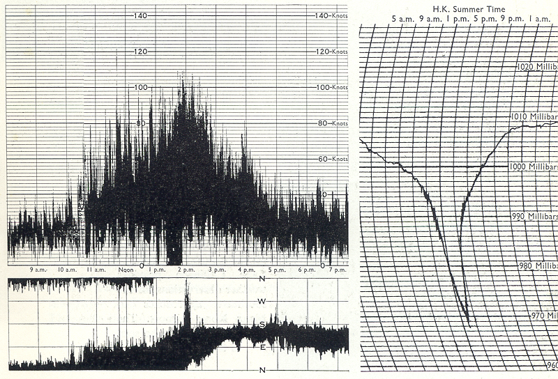
On the left is a copy of an anemogram showing the variation in wind speed and direction at the Royal Observatory during the passage of Typhoon Ruby. The barogram on the right shows the sharp dip in the barometric pressure that occurred.