Typhoon Hope
|
Typhoon Hope
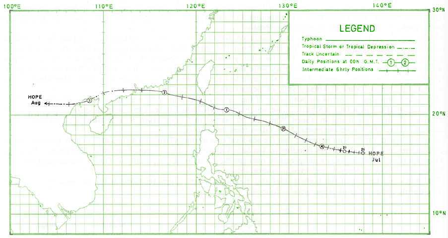
28 July - 3 August 1979 The track of this typhoon is shown in Figure 1
Typhoon Hope was the most severe typhoon to affect Hong Kong since Typhoon Rose in 1971. It passed rapidly over the New Territories on 2 August and caused twelve deaths and injured 260 people. Maximum gusts were generally around 100 knots increasing to about 130 knots at elevated sites. Maximum gusts of 130 knots, 123 knots and 111 knots were recorded at Cape D'Aguilar, Tate's Cairn and Chek Lap Kok respectively. A maximum gust of 108 knots was recorded at Star Ferry Pier, Kowloon. This is the highest gust recorded inside the harbour since Typhoon Rose in 1971. The instantaneous minimum mean sea-level pressure of 961.6 millibars at the Royal Observatory was second lowest on record, the lowest being 953.2 millibars in Typhoon Wanda, 1962. It also broke the record of minimum mean sea-level pressure in August, the previous record being 968.6 millibars set by Typhoon Shirley in 1968. Fortunately, Hope was a fast-moving typhoon. If Hope had moved slower during its passage over Hong Kong, casualties and damage to property could have been more severe, considering the violence of the typhoon.
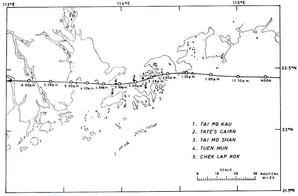
Hope began as a weak tropical disturbance on 25 July about 180 nautical miles south of Guam. It started moving westwards for a day and then moved northwest without much development during the next two days. The maximum sustained winds were only about 20 knots during this period. On the morning of 28 July, it intensified into a tropical depression about 420 nautical miles west-northwest of Guam. While moving west at about 5 knots, it intensified into a tropical storm and was named "Hope" in the early hours of 29 July. During the day, it moved west-northwest at about 7 knots. At 6.20 p.m. on 29 July, a reconnaissance aircraft reported that the minimum mean sea-level pressure was about 972 millibars and the maximum sustained winds were about 70 knots. Hope turned onto a northwest track and intensified into a typhoon on 30 July. Satellite pictures received at 9.00 a.m. showed that Hope had a circular dense overcast about 120 nautical miles in diameter. The spiral cloud bands were particularly active to the southeast of the centre (Figure 2). Hope gradually accelerated and by early next morning was moving at about 14 knots. At 7.25 a.m. on 31 July, a reconnaissance aircraft reported that the minimum sea-level pressure had dropped to about 926 millibars and maximum sustained winds were about 85 knots. At 9.00 a.m. on 31 July, the typhoon was centred about 530 nautical miles northeast of Manila. The dense overcast had expanded and was about 180 nautical miles in diameter (Figure 3). Spiral cloud bands became more evenly distributed around the centre and the circulation of the typhoon then covered an area about 600 nautical miles in diameter. The eye of Hope was well defined at this stage. Hope continued moving northtwest at an average speed of 16 knots and underwent explosive intensification during the day. By 9.00 p.m. on 31 July, the maximum sustained winds had risen to about 130 knots. At 6.48 a.m. on 1 August, a reconnaissance aircraft reported that maximum sustained winds near the centre of Hope were 140 knots. The minimum sea-level pressure was estimated to be 902 millibars. At 9.00 a.m. satellite pictures received at the Royal Observatory indicated that the dense overcast was about 150 nautical miles in diameter. Spiral cloud bands were increasingly active to the southwest of the centre. The circulation of the typhoon covered an area about 400 nautical miles in diameter. The maximum gusts were estimated to be in the region of 160 knots. At 1.00 p.m., Hope passed within 15 nautical miles of Batan, where maximum sustained winds of 100 knots were recorded and, one hour later, the mean sea-level pressure there dropped to a minimum of 950.9 millibars. Hope was closest to Taiwan in the afternoon. Gales and heavy rain associated with Hope caused much damage there. In eastern Taiwan, 38 houses collapsed and 132 houses were seriously damaged. Farmland and fish-ponds were devastated. A number of bridges were broken. In Hengchun, southern Taiwan, 500 houses were flooded and one person died. Widespread flooding was reported in other places over southern Taiwan. Tremendous damage was caused to crops and vegetation. While passing through the Bashi Channel, Hope took a west-northwest course and accelerated to enter the South China Sea at 18 knots. At 6.06 p.m. on 1 August, a reconnaissance aircraft reported that the minimum sea-level pressure was about 920 millibars. At 9.00 a.m. on 2 August, satellite pictures revealed that the dense overcast had shrunk to about 100 nautical miles in diameter but there was little change in the extent of the area covered by the spiral cloud bands (Figure 5). Maximum sustained winds near the centre of the typhoon were estimated to be around 110 knots at this time. Hope further accelerated to 28 knots and moved westward, reaching the eastern parts of Hong Kong at around 2.00 p.m. While Hope was moving across Hong Kong, it slowed down to an average speed of 17 knots. Hope then continued moving westward across the Zhu Jiang (Pearl River) estuary and swept through southern Guangdong (Kwangtung) at 22 knots. Macau survived Typhoon Hope with only minor damage and disruption to public services. No casualties were reported there. Hope weakened into a tropical storm around midnight while turning to move west-southwest. On 3 August, it passed over the northern coast of the Gulf of Tonkin at about 20 knots and dissipated about 110 nautical miles west of Hanoi. According to a Chinese newspaper in Guangzhou (Canton), the passage of Typhoon Hope across the southern part of Guangdong (Kwangtung) province was catastrophic. 37 counties were affected. About 100 people were killed or reported missing. More than 50 000 houses were severely damaged. A number of embankments were broken. Extensive destruction was caused to agricultural land. In Shenchun (Shum Chun), two people were killed, and more than 20 were injured. The city suffered a blackout for about 2 days because many overhead transmission lines were blown down. Thousands of trees in vast areas were uprooted. In Hong Kong, the Stand By Signal, No. 1, was hoisted at 3.30 p.m. on 1 August when Hope was about 420 nautical miles east-southeast of Hong Kong. Winds were moderate westerly or northwesterly. As winds began to freshen over Hong Kong, the Strong Wind Signal, No. 3, was hoisted at 10.00 p.m. on the same day. Winds turned northerly around 5.00 a.m. in the next morning and the Gale or Storm Signal, No. 8 NORTHEAST, was hoisted at 7.00 a.m. to warn the imminence of gales. The terrain of the territory sheltered most areas from northerly winds so that wind speeds were not particularly strong at this time. The first major spiral rain band of Hope appeared on the Royal Observatory's radar screen around 1.00 a.m. on 2 August and was some 160 nautical miles away to the east-southeast. The small eye of Hope which was about 10 nautical miles in diameter was first visible around 6.00 a.m. The double-walled eye of Hope was vividly displayed on the radar at 9.00 a.m. (Figure 6). As winds began to turn northwesterly, the Gale or Storm Signal, No. 8 NORTHWEST, replaced the No. 8 NORTHEAST Signal at 11.00 a.m. Winds strengthened rapidly to near-gale force in the next hour and gusts of 73 knots were recorded at Tate's Cairn and 59 knots at Cheung Chau. The Increasing Gale or Storm Signal, No. 9, was hoisted at 12.35 p.m. as winds turned west-northwest and the full force of the typhoon was felt in most places. The Hurricane Signal, No. 10, was hoisted at 1.00 p.m. when Hope was about 25 nautical miles east of the New Territories. Winds increased in strength very rapidly and reached hurricane force in the following hour. Gusts of 90 knots were recorded at Star Ferry Pier, 94 knots at the Royal Observatory, 106 knots at Waglan Island and 105 knots at Tate's Cairn. Intense rain echoes were observed on the radar within 60 nautical miles of the centre (Figure 7). The centre of Hope passed over Mirs Bay at around 2.00 p.m. Calm winds and bright sky were reported at Double Haven, Tai Po Kau and the Chinese University for about 20 minutes. The eye of Hope was near Tai Mo Shan around 3.00 p.m. Between 2.00 p.m. and 3.00 p.m., gusts of 108 knots were recorded at Star Ferry Pier, 107 knots at Waglan lsland, 123 knots at Tate's Cairn and 110 knots at Chek Lap Kok. Sweeping through the New Territories at 17 knots, Hope was centred near Tuen Mun around 3.30 p.m. Residents in Sek Kong, Yuen Long, Hung Shui Kiu, Tuen Mun, Sham Tseng and Tsuen Wan also reported calm winds and bright sky for about 15 minutes during the passage of the eye. There were also reports of seeing blue sky in the eye. The minimum mean sea-level pressure at the centre of Hope was estimated to be about 950 millibars while Hope was crossing over the western part of the territory. In areas to the south of the centre, winds turned through southwest to become southerly around 3.00 p.m. to 4.00 p.m. Gusts of 111 knots were recorded at Chek Lap Kok, 102 knots at Waglan lsland and 100 knots at Cheung Chau. Mean sea-level pressure rose sharply at all stations after the passage of the eye. Winds soon dropped below hurricane force and the No. 10 Signal was replaced by the No. 8 SOUTHEAST Gale or Storm Signal at 4.45 p.m. Gales from the south to southeast lasted for a few more hours. The No. 8 SOUTHEAST Gale or Storm Signal was replaced by the Strong Wind Signal, No. 3, at 8.05 p.m. while Hope was moving away from Hong Kong. Winds remained generally strong during the night but moderated on the morning of 3 August. The No. 3 Signal was lowered at 5.30 a.m. when Hope was centred about 270 nautical miles to the west of Hong Kong. The minimum values of mean sea-level pressure recorded at various stations were as follows: This table consists of 2 colums. The first column is 'Station' and the second column is 'Minimum mean sea-level pressure in millibars'. End ofsummary
The weather in Hong Kong was fine, sunny and hot on 1 August. A maximum temperature of 32.1°C was recorded at the Royal Observatory. It became cloudy in the following morning and some slight showers set in. Heavier rain occurred around noon and violent squally showers were reported when Hope was passing through the New Territories. The heaviest downpour at the Royal Observatory occurred between 2.00 p.m. and 3.00 p.m. when 82.1 mm of rain were recorded. Heavy squally showers continued until around 7.00 p.m. Showers then became lighter and less frequent during the night. It remained cloudy with occasional heavy showers on the following day. The daily rainfall amounts recorded during the period 1-4 August were as follows:
Typhoon Hope caused the highest toll of fatalities since Typhoon Rose in 1971. Twelve people were killed. 260 people were injured of whom 94 were hospitalised. About 2 000 people had to stay in temporary shelters provided by the Government. A total of 53 huts were destroyed and 796 people made homeless. At the height of the typhoon, eleven collisions involving eighteen vessels occurred in the harbour. Nine vessels had their cables parted from buoys and another two went aground. The Greek-registered 10 300-tonne vessel, M.V. 'Argonaut', rammed the piers of Star Ferry and went aground alongside the Kowloon Public Pier. A Panamanian vessel, M.V. 'New Ming Ren', ran aground at Tai Lam Chung in the New Territories. The refugee ship, M.V. 'Huey Fong', grounded at Tai Tsing Chau northeast of Lantau lsland. The Royal Navy patrol craft 'Beachampton' was hit by a drifting 3 500-tonne vessel at its typhoon mooring and suffered damage. Heavy damage was inflicted to many small craft. Hope sank 27 pleasure vessels and damaged another 69. Eighty-five dwelling boats were sunk while another 30 were damaged. The figures for other small craft and fishing vessels sunk or damaged were 56 and 108 respectively. Many people were evacuated from their damaged homes. One major evacuation occurred in Tai Po where more than 40 huts were damaged. In Tai Hang, about 150 people had to be evacuated because the roofs of their squatter huts had been blown away. Two two-storey buildings in Sheung Wan and 25 squatter huts in Ngau Tau Kok had to be evacuated because they were in danger of collapsing. Three wooden huts on rooftops in Temple Street were blown down. About 100 people lost their homes in two separate squatter fires which broke out in Wan Chai and Shek O Village while Hope was affecting Hong Kong. Numerous landslips occurred on both sides of the harbour, but none were serious. Two wooden huts in Shau Kei Wan collapsed in a landslip but no one was hurt. At Oi Man Estate, a minor landslip occurred with little damage. 200 squatters living in Tsuen Wan and 60 people in Chung Hom Kok Road were evacuated after landslips. Many roads were obstructed with fallen trees and debris. A tide gauge at Tai Po Kau indicated that the sea-level rose abruptly from 0.9 metres at 2.30 p.m. to a maximum of 4.3 metres at 4.30 p.m. Serious flooding in Tin Sam Village near Lam Tsuen River in Tai Po caused the death of three persons. Flooding was widespread all over the New Territories, especially in Tai Po Market and Sha Tin. Flooding was also reported in several urban areas. The times and heights of the highest tides and maximum storm surges recorded at various locations in Hong Kong during the passage of Hope were as follows:
Public transport and all kinds of traffic came to a complete halt at the height of the typhoon. Five submerged telephone cables under the harbour were damaged by ships dragging their anchors. Telephone communications were impeded. About 19 000 telephone lines were out of order. There was widespread disruption to power supplies in the New Territories. Power failure was also reported in various districts over Hong Kong. About 75 per cent of vegetables, flowers and fruit trees in the New Territories were destroyed or severely damaged. There was extensive damage to trees, shrubs and plants throughout Hong Kong. A survey indicated that Typhoon Hope destroyed more than 19 000 fruit trees, 1200 hectares of vegetables, 140 hectares of cultivated flowers and more than 3 500 pots flowers. Nearly 113 000 head of livestock were also destroyed. The worst hit areas were around Yuen Long, Tuen Mun, Ping Shan, Ha Tsuen, San Tin, Kam Tin, Pat Heung and Sap Pat Heung, although there was also damage around Tai Po, Sai Kung and Tsuen Wan. More than 7 700 farmers registered claims for compensation for damage. 270 metal canisters containing lethal cyanide salt were flung into the harbour when a dangerous goods storehouse in Yau Ma Tei was damaged by sea waves. |
|||||||||||||||||||||||||||||||||||||||||||||||||||||||||||||||||||||||||||||||||||||||||||||||||||||||||||||||||||||||||||||||||||||||||||||||||||||||||||||||||||||||||||||||||||||