Typhoon Ellen
Typhoon Ellen (8309)
29 August - 9 September 1983
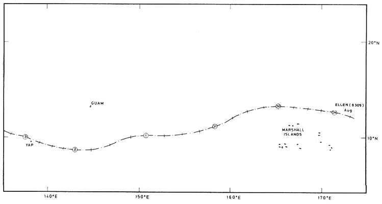
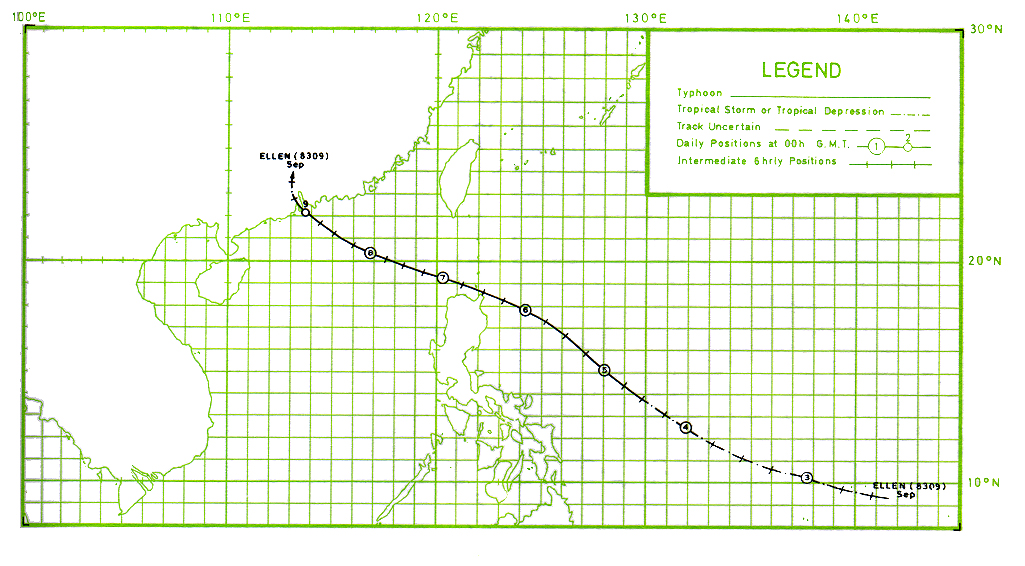
The track of this typhoon is shown in Figures 1 and 2
Typhoon Ellen was the worst typhoon to strike Hong Kong since Typhoon Hope in 1979. It passed about 7 nautical miles southwest of Fan Lau, the southwestern tip of Lantau lsland. 10 people were killed and 12 were missing. The Hurricane Signal, No. 10, was hoisted for a duration of 8 hours, which was the same as during Typhoon Wanda in 1962. Hurricane force winds lasted for 5 hours at Cheung Chau. This was a longer duration than in Typhoon Wanda in 1962, Typhoon Hope in 1979 or Typhoon Rose in 1971 as a result of Ellen's track and its relatively slow movement. The highest gust over Hong Kong, 134 knots, was recorded at Stanley. A maximum gust of 128 knots was recorded at Cheung Chau, which was the highest gust there since 1953. At Waglan lsland, the maximum gust of 122 knots was the highest since Typhoon Ruby of 1964.
 |
(I) |
 |
(II) |
Figure 1. Track of Typhoon Ellen (8309) : 29 August - 9 September. |
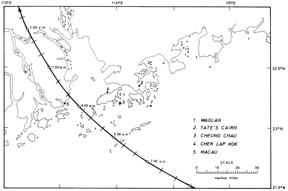 |
Figure 2. Trajectory of the centre of the eye of Typhoon Ellen near Hong Kong on 9 September 1983. |
Typhoon Ellen originated as a tropical depression near the Marshall lslands over the Pacific on 29 August. It moved westwards and intensified into a typhoon on 4 September about 520 nautical miles east of Manila. Ellen continued to intensify and its eye became discernible on satellite pictures as it travelled northwestwards at 12 knots towards the Balintang Channel. Ellen attained its maximum intensity during the morning on 6 September (Figure 3a). At 7.43 a.m. a reconnaissance aircraft reported a minimum sea-level pressure of 928 millibars and a maximum sustained surface wind of about 110 knots near the centre about 270 nautical miles northeast of Manila. 21 Taiwanese fishermen were drowned when their boats capsized in waters off the Philippines. Ellen weakened as it crossed the Balintang Channel at 10 knots in a west-northwest direction. It passed about 20 nautical miles off the northern coast of Luzon and entered the South China Sea in the morning of 7 September (Figure 3b). At 7.49 a.m. a reconnaissance aircraft reported a minimum pressure of 966 millibars and a maximum sustained surface wind of 70 knots. It moved west-northwestwards towards Dongsha at 8 knots and both satellite pictures and aircraft reconnaissance reports showed that it reintensified slightly. At 7.15 p.m. on 7 September, a reconnaissance aircraft reported a minimum sea-level pressure of 959 millibars near the centre. Ellen passed about 15 nautical miles southwest of Dongsha at about 9.00 a.m. on 8 September (Figure 3c). Two fishing junks from Hong Kong capsized and three others went aground while they were taking shelter there. 46 people were saved but 5 were missing. 10 fishing junks from Taiwan also took shelter near Dongsha Qundao and were either sunk or driven aground. 100 fishermen were saved but 41 were missing. In the afternoon of 8 September, an eye was again observed on the satellite picture (Figure 3d). Ellen continued west-northwestwards at 8 knots approaching the South China coast. At 11.00 p.m. on 8 September, the M.V. 'Frankfurt Express' reported a surface wind of 52 knots about 80 nautical miles northeast of the centre. A Taiwanese junk capsized about 120 nautical miles south of Hong Kong during the night. One fisherman was saved but 6 were missing. Satellite pictures taken during the night of 8 September are shown in Figure 4.
Ellen passed to the south of Hong Kong moving in a northwest direction. It came closest to Hong Kong around 7.00 a.m. on 9 September (Figure 4d) with its centre about 7 nautical miles off Fan Lau, the southwestern tip of Lantau lsland. The minimum pressure and maximum sustained surface wind near the centre were estimated to be 960 millibars and 85 knots respectively. The eye of Ellen was over Macau from about 8.20 a.m. to 8.45 a.m. when winds there dropped to about 15 knots for 25 minutes. Maximum surface winds of 52 knots and a minimum sea-level pressure of 970 millibars were recorded at Macau. 16 people were killed and about 50 sampans and junks capsized. Ellen then moved north-northwest into Guangdong causing tremendous damage to eight counties in the province. A total of 16 people were killed, 92 injured and 16 were missing in Zhuhai, Shenzhen and Panyu. In Zhuhai, 180 houses were completely destroyed and almost 1 000 hectares of crops damaged. One person was killed. 6 boats were wrecked near the town and thousands of telephone and telegraph poles were brought down. 5 people were killed in Shenzhen and 3 in Panyu. 7 Chinese navy sailors were killed during rescue operations in the Zhu Jiang estuary. At 4.00 p.m. on 9 September, the centre of Ellen passed about 10 nautical miles west of Guangzhou, where a sea-level pressure of 993.5 millibars was recorded. At 4.10 p.m. the water level of Zhu Jiang near Guangzhou rose to 2.42 metres, the highest since 1942. In Dongguan county, 100 hectares of crops were inundated and more than 32 000 people were marooned as a result of extensive flooding. As Ellen moved further inland it weakened into a tropical storm and dissipated rapidly during the night.
In Hong Kong the Stand By Signal, No. 1, was hoisted at 5.00 a.m. on 7 September when Ellen was about 420 nautical miles east-southeast of Hong Kong. Winds in Hong Kong were light and mainly from the east. Winds became northerly the next morning. The Strong Wind Signal, No. 3, was hoisted at 7.45 a.m. and the wind became fresh to strong during the afternoon. The Northeasterly Gale or Storm Signal, No. 8 NE, was hoisted at 4.45 p.m. By 9.00 p.m., winds over Hong Kong were generally strong from the north to northeast and gale was reported at Waglan lsland. Between midnight and 1.00 a.m., the hourly mean wind speed at Waglan lsland increased rapidly from 59 knots to 76 knots. The Increasing Gale or Storm Signal, No. 9, was hoisted at 1.00 a.m. on 9 September. The Hurricane Signal, No. 10, was hoisted at 2.00 a.m. As Ellen passed to the south of Hong Kong moving in a northwest direction, Waglan lsland was the first to experience hurricane force winds. Between 4.00 and 5.00 a.m. Waglan lsland reported its maximum hourly mean wind, 86 knots from the southeast. Between 6.00 a.m. and 7.00 a.m. Cheung Chau reported its maximum hourly mean wind of 90 knots and the maximum gust of 128 knots from the south-southeast. Hurricane force winds continued to affect Hong Kong for the next few hours. Winds dropped below hurricane force at Cheung Chau around 10.00 a.m. and the No. 10 Signal was replaced by the Southeasterly Gale or Storm Signal, No. 8 SE. Winds veered from southeast to southwest as Ellen moved further away on a northwesterly track. At 2.00 p.m., the No. 8 SE Signal was replaced by the Southwesterly Gale or Storm Signal, No. 8 SW Signal. The No. 8 SW Signal was replaced by the No. 3 Signal at 5.37 p.m. when gales subsided. Winds remained gusty fresh to strong for most of the night and all signals were lowered at 9.20 p.m. on 9 September.
The minimum values of mean sea-level pressure recorded at various stations were as follows :
| Station |
Minimum mean sea-level pressure in millibars |
| Cheung Chau |
972.7 |
| Waglan Island |
976.7 |
| Tate's Cairn |
980.0 |
| Royal Observatory |
983.1 |
| Hong Kong Airport |
987.4 |
The maximum hourly mean wind speeds and maximum gust peak speeds together with associated wind directions recorded at some selected locations during the display of signals were as follows :
| Location | Maximum mean hourly wind speed in knots with direction in points |
Maximum gust peak speed in knots with direction in points |
||
| Royal Observatory | ENE & E |
46 |
E |
100 |
| *Hong Kong Airport (SE) | E |
57 |
E |
110 |
| *Hong Kong Airport (NW) | SE |
57 |
E |
93 |
| *Waglan lsland | SE |
86 |
E |
122 |
| *Tate's Cairn | E |
68 |
ENE |
118 |
| *Cheung Chau | SE & SSE |
90 |
SSE |
128 |
| Star Ferry | E |
54 |
ESE |
93 |
| Green Island | S |
74 |
S |
119# |
| *Tsim Bei Tsui | SSE |
61 |
SSE |
97 |
| Tai O | E |
61 |
E |
119# |
| *Castle Peak | SSE |
48 |
SSE |
92 |
| Chek Lap Kok | Not available |
Not available |
||
| Lei Yue Mun | ENE |
68 |
E |
100 |
| Yau Yat Chuen | SE |
49 |
SE |
88 |
| Kowloon Tsai Hill | ESE |
56 |
E |
109 |
| Kwai Chung | SE |
60 |
SE |
91 |
| Stanley | SE |
87 |
ESE |
134 |
# estimated, exceeding upper limit of anemogram.
(Stations marked with an asterisk were equipped with Dines pressure-tube anemographs and wind speeds should be adjusted to compensate for variations in air density for investigations requiring high precision).
Barograms and anemograms of Typhoon Ellen recorded at various meteorological stations in Hong Kong during the period 8 - 9 September are reproduced in Figures 6 and 7.
The weather was fine and hot in Hong Kong on 7 September. It became cloudy with scattered showers and squally thunderstorms during the morning on 8 September when the outer rainbands of Ellen began to affect the territory. The rain became more frequent as Ellen approached Hong Kong during the night. The radar showed a circular eye and intense echoes in the southern quadrant of the typhoon (Figure 5). The rain was heaviest just after dawn on 9 September. A tornado was reported at Shek Wu Wai San Tsuen, San Tin, around 1.15 p.m. The effects of the tornado were felt at ground level for a few seconds. Several wooden huts were destroyed but no one was injured. This was the second tornado known to cause some damage in Hong Kong. It was also the first tornado reported during the passage of a typhoon in Hong Kong. It remained overcast with rain for most of 9 September. The weather improved the next day. There were scattered showers but also sunny periods. The daily amounts of rainfall recorded were as follows :
Royal Observatory |
Cheung Chau |
Tate's Cairn |
|
| 7 September | Nil |
2.1 mm |
0.2 mm |
| 8 September | 57.8 mm |
46.5 mm |
34.4 mm |
| 9 September | 172.4 mm |
79.6 mm |
86.7 mm |
| 10 September | 1.6 mm |
Nil |
2. 5 mm |
| Total: | 231.8 mm |
128.2 mm |
123.8 mm |
The times and heights of the highest tides and maximum storm surges recorded at various locations in Hong Kong during the passage of Ellen were as follows:
Location |
Highest tide
above chart datum |
Maximum storm
above astronomic |
||||
|
Height
(m)
|
Date |
Time |
Height
(m)
|
Date |
Time |
|
Chi Ma Wan |
3.06 |
9 Sep. |
7.00 a.m. |
1.80 |
9 Sep. |
5.30 a.m. |
Tai Po Kau |
3.06 |
9 Sep. |
7.30 a.m. |
1.74 |
9 Sep. |
2.00 a.m. |
Tsim Bei Tsui |
3.62 |
9 Sep. |
10.30 a.m. |
1.22 |
9 Sep. |
10.00 a.m. |
Lok On Pai |
3.20 |
9 Sep. |
10.30 a.m. |
0.75 |
9 Sep. |
10.30 a.m. |
On this occasion, it was fortunate that the maximum storm surges occurred at times when the normal tide levels were relatively low. The highest tide levels were therefore not as high as they would have been had the maximum surges occurred at the times of normal high tides.
Typhoon Ellen brought about a death toll of 10 with 12 people missing and 333 people injured. (The incidents involving the 'Osprey', a 56-metre pleasure yacht, and fishing boats near Dongsha are included). 274 huts collapsed and about 1 600 people were made homeless. At the height of the typhoon, 44 ocean-going vessels were in serious difficulties. 26 ships totalling 250 000 tonnes ran aground, mainly in north Lantao and the Kau Yi Chau area. A couple of the ships listed badly and 23 others were involved in a total of 15 collisions. The stern of the 9 500-tonne Singapore freighter, 'Golden Fortune', one of 5 ships which went aground at Kau Yi Chau, was partly awash. The 9 300-tonne Taiwanese vessel 'Hua Lien' smashed the Mobil Oil Co.'s berth on Tsing Yi Island. About 100 metres of the jetty, pipeline, supporting piles and mooring dolphins were completely destroyed. The 6000-tonne Cypriot cargo ship, 'City of Lobito', came close to slamming into a modern beachside apartment complex on Tung Wan, Cheung Chau. The 5 300-tonne 'Pacific Coral' was stranded on a shallow bank off northern Lantao and listed heavily. The 1000-tonne container ship, 'Zim Manila II', crunched high on the rocks at Hei Ling Chau. Ellen's toll on shipping in terms of numbers exceeded those of Typhoon Rose in 1971 and Typhoon Wanda in 1962. Rose claimed 34 shipping casualties and Wanda 36. But unlike the other two, Ellen caused no reported casualties among seamen. However, 2 fishermen were drowned and 1 was missing after a fishing boat went aground at Tai Long Wan on Lantao. 5 others were missing when their junks capsized at Dongsha Dao. The pleasure vessel 'Osprey' sank about 12 nautical miles south of Hong Kong. Only 1 crew member was saved near Wanshan Qundao about 60 nautical miles south of Hong Kong. 2 bodies were found and 6 other crew members were missing. 135 small craft were sunk and 225 others were damaged. These included pleasure craft, fishing vessels, dwelling boats, etc. Of these, about 200 pleasure craft were sunk or damaged, mostly in Pak Sha Wan, Sai Kung, Aberdeen and Deep Water Bay.
Initial reports indicated that 1 500 hectares of crops and about 80 per cent of the territory's vegetables under cultivation were damaged by floods and winds. About 10 000 farmers were affected. About 100 000 chickens and 2 300 pigs were drowned in the flooding. The most seriously affected areas were Yuen Long and Kam Tin. 120 hectares of fish ponds were flooded, mostly in Tin Shui Wai, Kam Tin and Ngau Tam Mei. There was also tremendous destruction to mariculture craft in Sok Kwu Wan, Silver Mine Bay, Sha Tau Kok and Tap Mun. The total loss of crops and livestock amounted to HK$50 million.
Some 80 000 households in Kowloon and the New Territories suffered power failure when Ellen was closest to Hong Kong. Power went out on Lantau lsland around 3.00 a.m. There were no major disruptions on Hong Kong Island. Some places in Kwun Tong, Sha Tin, Fanling, Sai Kung, Yuen Long and Lantau lsland had no electricity supply for more than 4 days. Water supply was interrupted at several estates in Ha Kwai Chung because of the power failure at Lai Chi Kok Pumping Station. Water supply at Mei Foo Sun Chuen was also interrupted due to the failure of the estate's internal service pumps which were flooded.
There was a total of 150 reports of flooding and 250 reports of roads being blocked by fallen trees, collapsed scaffolding, sign-boards and other debris. Mei Foo Sun Chuen was flooded by sea water up to a maximum depth of about 2 metres in places. 12 000 trees in the urban area and another 2 000 in the New Territories were uprooted or broken. 1 092 traffic lights were damaged and 542 bollards smashed. Public transport came to a complete halt at the height of the typhoon. At the airport, there were 7 flight cancellations, 13 delayed departures and 9 diversions.
From a survey of loss adjusters and underwriters, insurance claims totalled about HK$300 million, including HK$180 million for wind and water damage to domestic, commercial and industrial premises, HK$90 million for damage on construction sites, HK$20 million for salvage and repairs to grounded ships and HK$10 million for pleasure boats destroyed or damaged.
The only relief was the water Ellen brought to the reservoirs - 32 million cubic metres. High lsland Reservoir was full for the first time since its completion in 1978, and of Hong Kong's 17 reservoirs, 11 were full.