Report on Severe Tropical Storm Merbok
Figures
Provisional track of Merbok: 11 – 13 June 2017
Provisional track of Merbok near Hong Kong
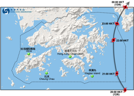
Provisional track of Merbok moving across Hong Kong
Rainfall distribution on 11 - 13 June 2017
10-minute mean wind direction and speed recorded at various stations in Hong Kong at 8:20 p.m. on 12 June 2017
10-minute mean wind direction and speed recorded at various stations in Hong Kong at 11:40 p.m. on 12 June 2017
Traces of mean sea-level pressure recorded at the Observatory Headquarters and Waglan Island between 12 and 13 June 2017
Infra-red satellite imagery around 8 p.m. on 12 June 2017, when Merbok was at peak intensity with estimated maximum sustained winds of 90 km/h near its centre
Image of radar echoes at 9:36 p.m. on 12 June 2017
Image of radar echoes at 10 a.m. on 13 June 2017
A retaining wall at Tai Tam Road in Stanley collapsed under the heavy rain(courtesy of the Geotechnical Engineering Office and the Civil Engineering and Development Department)
Tables
Maximum gust peak speeds and maximum hourly mean winds with associated wind directions recorded at various stations when the tropical cyclone warning signals for Merbok were in force
Periods during which sustained strong and gale force winds were attained at the eight reference anemometers in the tropical cyclone warning system when tropical cyclone warning signals for Merbok were in force
Daily rainfall amounts recorded at the Hong Kong Observatory Headquarters and other stations during the passage of Merbok
Times and heights of the maximum sea level and the maximum storm surge recorded at tide stations in Hong Kong during the passage of Merbok