Introduction to Air Pressure (Part II)
Introduction to Air Pressure (Part II)
HUNG Fan-yiu
How is the air pressure related to temperature?
We know that air pressure is the weight of the column of air above a horizontal surface of unit area. Everything else being equal, a cold air column, because of its higher air density, is heavier than a warm air column and thus produces a higher air pressure.
How is the air pressure related to gravity?
We have a weight because the Earth exerts an attractive force on us. We call this "gravity". It tends to vary quite a lot on astronomical bodies. This is why an astronaut can jump higher on the Moon, where the gravity is smaller, than on the Earth. Gravity also varies at different parts of the Earth, though to a much smaller extent. For this reason, everything else being equal, the air pressure (which is the weight of air column above a place) can vary from place to place on the Earth because of the slight changes in gravity.
What is standard atmosphere?
To enable comparison of air pressure at different places, it is convenient to convert the air pressure to a common level, e.g. the sea level. The meteorological community makes use of the "standard atmosphere" to convert pressure readings at different places to the sea level. The standard atmosphere is a hypothetical profile of atmospheric temperature, pressure and density agreed internationally.
What are QFE, QNH and QFF?
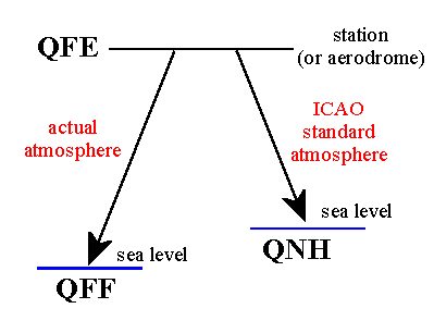
In aviation, specify terms such as QFE, QNH and QFF are used to describe the air pressure according to different applications. QFE is the pressure at the station (or aerodrome) level. QNH is the pressure at mean sea level, reduced from QFE by applying corrections according to the International Civil Aviation Organisation's standard atmosphere. QFF is the pressure corrected to mean sea level, taking into account the actual temperature conditions.
What is an isobar? What is its use?
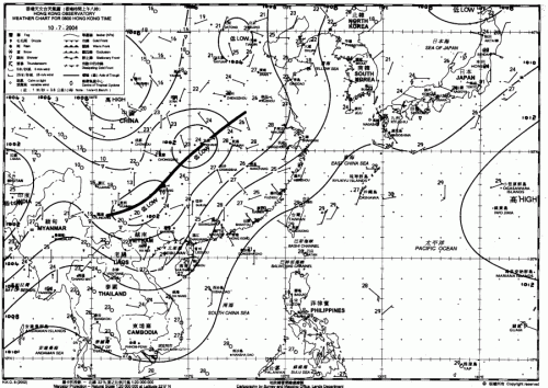
Pressure readings measured at different weather stations (after making corrections according to temperature etc.) at the same time are plotted on a weather chart. Meteorologists then draw lines to show places with the same pressure. These lines are called isobars. Isobars are usually drawn at 2 or 4 hPa intervals. Isobars are useful in revealing the surface pressure pattern.
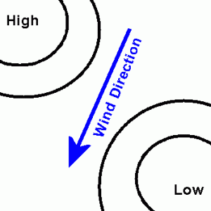
Isobars can also be used to deduce wind conditions. In the northern hemisphere, if the air pressure is higher (lower) on your left, then the wind will generally blow towards you (from your back). Also, everything else being equal, winds tend to blow harder (gentler) where isobars are closer together (further apart).
What are the common pressure patterns?
The ability to recognize and understand pressure features on the surface is important in weather forecasting. Pressure features commonly observed on a weather chart are described below:-
Depression / Cyclone / Area of low pressure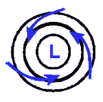
|
When the air pressure in a region is lower than its surrounding, the feature is called a depression, a cyclone or an area of low pressure. In the northern (southern) hemisphere, the air around a depression moves in a counterclockwise (clockwise) direction (looking from above). Near the Earth's surface, however, friction tends to cause the air to move slightly inward across the isobars. As it moves into an area of low pressure, the air has nowhere to go but up. Hence, a low pressure area is usually associated with unstable weather (e.g. clouds, rain or showers). |
Anticyclone / Area of high pressure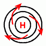
|
When the air pressure in a region is higher than its surrounding, it is called an anticyclone or an area of high pressure. In the northern (southern) hemisphere, the air around an anticyclone moves in a clockwise (counterclockwise) direction. Near the Earth's surface, however, friction tends to cause the air to move slightly outward across the isobars. In an area of high pressure the air is generally stable and is usually associated with fine weather. |
Ridge of high pressure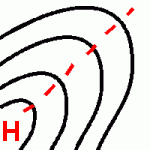
|
A ridge of high pressure is an elongated area of high pressure. On the weather chart, it sometimes has associated with it a ridge line. The pressure there is higher than that at neighbouring points on either side of the ridge line. |
Trough of low pressure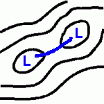
|
A trough of low pressure is an extended area of low pressure. On the weather chart, it has associated with it a trough line. The pressure there is lower than that at neighbouring points on either side of the trough line. |