Know more about Severe Weather Information Centre
Know more about Severe Weather Information Centre
TAM Hiu-ching
October 2024
The Severe Weather Information Centre (SWIC) website (https://severeweather.wmo.int) of the World Meteorological Organization (WMO) is a one-stop portal for severe weather information around the globe, and provides official weather observations and warnings worldwide. The website is developed and operated by the Hong Kong Observatory (HKO) on behalf of the WMO. It began trial run in 2001 and became operational in 2005. The SWIC website was revamped in 2018 to employ Geographic Information System (GIS) to aid visualization of warnings on map. A new version (3.0) of SWIC website was launched in early 2024. Besides adopting a new menu to facilitate easier navigation and search for information, the website was optimized for faster loading speed and was included with official weather warnings from more WMO Members as well as maritime warnings.
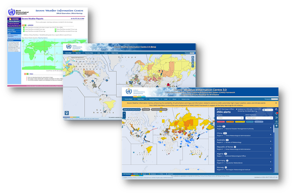
Figure 1 The evolution of the SWIC website is depicted, viz. the first generation of website in early stage (left), the second generation of website that displayed weather information on GIS-powered interactive maps (middle), the third generation of the enhanced website launched in early 2024 (right).
The SWIC website aggregates WMO Members’ warnings disseminated in Common Alerting Protocol (CAP) format that includes information in severity, urgency and certainty. CAP is an international standard format for emergency alerting and public warning. WMO recommended the use of CAP to disseminate warnings in its technical regulations. The severity of the warning is visualised on the SWIC3.0 in different colours with reference to ISO 22324 which is an international standard to provide guidelines for colour codes to indicate severity of hazard in public warnings. This facilitates users to grasp the real-time warning information around the globe at a glance.
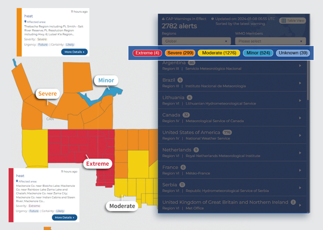
Figure 2 SWIC website displays weather warnings issued by alerting authorities, in particular meteorological and hydrological services, around the world. The effective areas of the warnings are visualised on the map and coloured according to ISO 22324.
Moreover, SWIC website shows information on tropical cyclones and severe weather observations, including gales, heavy rain/snow, thunderstorms and fog, worldwide provided by meteorological and hydrological services. The information can help users to be aware of the latest affected areas and conditions of severe weather and prepare for weather changes beforehand.
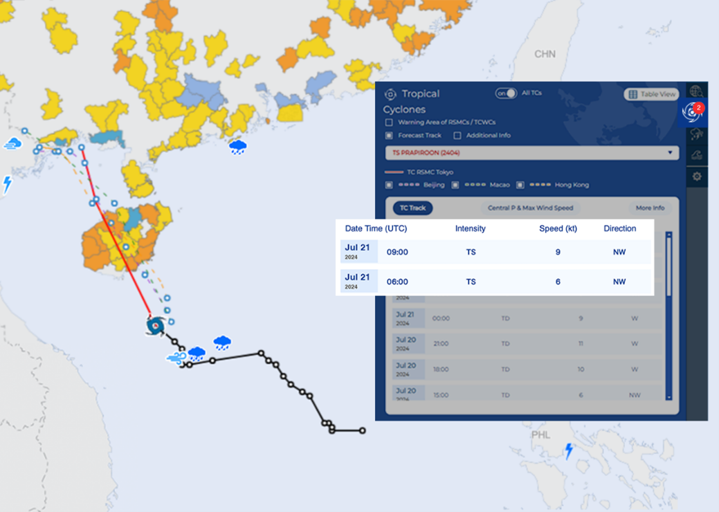
Figure 3 An example of the SWIC website shows the advisories about Tropical Cyclone Prapiroon in July 2024, including the analysed position, intensity, movement speed and direction, and forecast tracks etc. The map also depicted the weather reports revealing heavy rain and high winds near Prapiroon.
SWIC website is a core component of the WMO Global Multi-hazard Alert System framework for increasing the availability of authoritative warnings and information related to extreme and potentially high-impact weather, water, and climate events to contribute to the implementation of the United Nations Early Warnings for All initiative[1]. In addition, the website fosters the sharing of authoritative warnings among WMO Members, and promotes the visibility of Members, which is crucial for acquiring resources to strengthen and sustain their weather warning services and to develop and enhance societal resilience.
Weather sees no boundaries. The Observatory will continue to collaborate with the WMO to ensure public safety and disaster risk reduction for the betterment of the world.
Note:
[1] Early Warnings for All is a United Nations initiative to ensure everyone on Earth is protected from hazardous weather, water or climate events through life-saving early warning systems by 2027.
[1] Early Warnings for All is a United Nations initiative to ensure everyone on Earth is protected from hazardous weather, water or climate events through life-saving early warning systems by 2027.