The Tropical Cyclone Warning System in Hong Kong
The Tropical Cyclone Warning System in Hong Kong
The Hong Kong Observatory conducted a comprehensive review of the tropical cyclone warning system in 2006. During the review process, the Observatory reached out to different sectors of the community to consult their views. A public opinion survey was also carried out to gauge the public needs and expectations with respect to the warning system.
Starting from the tropical cyclone season in 2007, the Observatory implemented a series of measures with respect to the tropical cyclone warning system. In particular, the reference for the issue of No.3 and No.8 signals was expanded from the Victoria Harbour to a network of eight reference anemometers covering the whole of Hong Kong.
In 2013, the Observatory replaced Wetland Park by Lau Fau Shan as one of the eight reference anemometers in the tropical cyclone warning system.
With a view to improving the public understanding of the tropical cyclone warning system and encouraging a better use of the weather information provided by the Observatory, some salient points are given below in the format of questions and answers.
What are the differences between the present tropical cyclone warning system and the old system just before 2007?
The present tropical cyclone warning system has been in use since 2007.
Comparing with the old tropical cyclone warning system before 2007, the present system has changed in the following aspects:
(a) expand the reference for the issue of No.3 and No.8 signals from the Victoria Harbour to a network of eight reference anemometers near sea level covering the whole of Hong Kong (see Fig.1 and Note below);
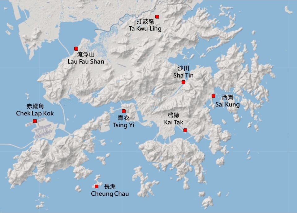
Fig.1 Network of reference anemometers in the tropical cyclone warning system
(b) issue No.3 or No.8 signal (as the case may be) when half or more anemometers in the reference network register or are expected to register strong winds or gale/storm force winds respectively and the wind condition is forecast to persist;
(c) enhance dissemination of regional wind information. In tropical cyclone bulletins for the media, specifically indicate the locations where the winds are significantly higher than the general wind conditions in Hong Kong; and
(d) issue an advisory in tropical cyclone bulletins that the traveling public should check with airlines before departing for the airport when weather conditions likely to cause significant disruptions to flight operations are expected.
[Note: Lau Fau Shan station has replaced the nearby Wetland Park station as a reference anemometer station starting from 2013. The anemometer at Chek Lap Kok has moved from the Centre Runway to the North Runway since 2024.]
In the present system, why only 8 anemometer stations but not all are chosen as the reference stations?
When devising the network of reference anemometer stations, consideration has been given to the terrain of Hong Kong being naturally separated by mountain ranges. The eight anemometers have been selected on account of their good exposure and geographical distribution. Together, they provide a broad picture of the wind condition in Hong Kong.
What is the reason for replacing the reference station at Wetland Park by Lau Fau Shan?
Wetland Park station has been working normally since its launch in November 2005. The station is located inside Wetland Park near Tin Shui Wai in the northwestern part of the New Territories. It is exposed to natural wetlands to its east, while some high-rise buildings are located to its far west (about 500 to 700 metres away). Generally speaking, the station is fairly well exposed. However, the density of buildings near the station has been increasing in recent years. Statistics over the years indicated that the monthly mean wind speed of Wetland Park station was on a gradual decreasing trend in the past few years. This revealed that the wind speed at Wetland Park would be decreasing under the influence of its changing surrounding environment including the construction of new buildings.
In addition, there are planned construction projects about 300 metres to the west of the station. Buildings of 3 to 11 storeys, with the tallest one of about 50 metres high, will be constructed. This is expected to further reduce the exposure to the west of Wetland Park station. To ensure that the tropical cyclone reference anemometer network can continue to reflect the general wind condition over Hong Kong, it is necessary to review the reference station in the northwestern part of the New Territories.
The Lau Fau Shan station is located next to the Wetland Park station. There has been no significant change in the mean wind speed at Lau Fau Shan in the past few years. The station is considered to be a suitable replacement of Wetland Park station.
Why the criterion for the issue of No.9 or No.10 signal is different from that for No.3 or No.8 signal?
As for No.9 and No.10 signals, they are normally meant to warn of direct or near direct hit of a typhoon. As there is enormous spatial variation of wind direction and speed near the eye of a typhoon, there is little point in making reference to winds at a single location in the consideration of signals. Thus, the HKO has all along made reference to the wind condition of the whole territory in deciding on the issue of No.9 and No.10 signals.
Can the tropical cyclone warning system reflect winds in different regions of Hong Kong?
Due to local topography and the built environment, wind condition in different parts of Hong Kong can vary appreciably. A numbered tropical cyclone signal can provide a general warning for the public, but it has an inherent limitation in communicating varying wind speeds at different locations. In the present system, regional wind information will be disseminated to assist people in making decisions for their arrangements.
What is the impact on wind speed when the rainband of a tropical cyclone moves across Hong Kong?
When the rainband of a tropical cyclone is close to or moves across Hong Kong, it is usually accompanied with squalls. Wind speed in places of Hong Kong may abruptly increase . After the passage of the rainband, the high wind speed brought about by intense gusts usually drops in the order of ten minutes. The situation is similar to that when a squall line moves across Hong Kong, bringing short-lived severe and potentially damaging squalls.
How does the Observatory enhance the dissemination of regional wind information?
Regional wind information are readily available on the Observatory website, MyObservatory and from the Dial-a-weather system. The information is updated every 10 minutes. The Observatory will liaise with the media to broadcast such information on an hourly basis when wind conditions at certain locations are significantly above the level indicated by the territory-wide warning signal under the present system.
Are aircraft operations affected by tropical cyclone warning signals?
The tropical cyclone warning system is designed for use by the public. Aircraft operations do not depend on tropical cyclone signals. In respect of wind, aircraft operations at the airport are mainly affected by crosswinds (i.e. winds blowing across the aircraft from the side) as well as windshear and turbulence, rather than wind speed per se. Even if the No. 8 signal is in force, if the wind is blowing along the runway, it may not affect aircraft operation. On the other hand, if the wind is blowing across the runway, it may exceed the operating limit of aircraft, thus affecting aircraft operation. The traveling public should check the latest flight information and the transportation conditions to and fro the airport before departing for the airport.
What should people do if they are in gales-affected region after HKO has issued the No.3 signal?
If the employees have difficulties in reporting for duty during severe weather situations, they should inform their supervisors or employers as soon as practicable. The employers should give prime consideration to employees' safety both in the workplace and during their journeys to and from work. They should also adopt a flexible approach in dealing with cases of absence or late for work due to inclement weather condition. On the student side, parents should pay attention to the announcements on school arrangements made by the Education Bureau, and use their discretion in deciding whether or not to send their children to school based on the condition in their regions. In addition, the Education Bureau and the Labour Department will help reinforce the relevant message to schools, parents and employers.
Is it still needed to have arrangement of work suspension with the present building structures and mass transportation network?
The Observatory issues tropical cyclone warning based on the wind condition in Hong Kong to alert people of the general wind condition over the whole territory. It also provides regional weather information to assist members of the public and various trades and industries to take appropriate precautionary measures and make proper work arrangements. At present, various trades, industries and organisations will make reference to the guidelines provided by the Labour Department and decide their work arrangements having regard to the nature and requirements of their operations when tropical cyclone warning is in force.
Is it possible for the Observatory to enhance the communication with the Education Bureau in inclement weather situations?
The Observatory has been keeping close liaison with the Education Bureau (EDB) during severe weather situations. The Observatory will provide EDB with the necessary weather information in support of their decision-making on class suspension. In addition, the Observatory has also implemented a dedicated webpage for schools in its website to provide regional weather information for reference.