The Looks of Water in Summer
The Looks of Water in Summer
PAN Chi-kin
September 2011
Heavy rain occurs most often during the summer months in Hong Kong and brings about flooding and landslips, causing inconvenience to people. Why do we have more rainstorms in the summer? The main physical conditions for heavy rain events are adequate supply of water vapour, strong uplift motion of surrounding air and an unstable atmosphere. These will be discussed one by one below.
In general, moist air reaching Hong Kong could come from the south, originating from the South China Sea and even as far away as the Bay of Bengal. It could also be come from the east, originating from Western Pacific. In summer, solar heating heats up the continental landmass over Mainland faster than the seas. The differential warming leads to the summer monsoon and creates a steady wind blowing from the sea toward the land, bringing an abundant supply of moist air.

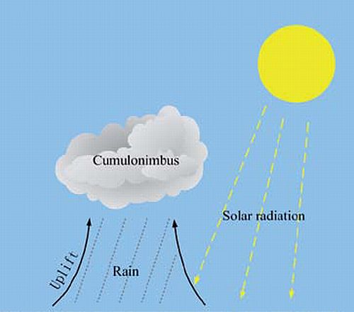
Fig.1 Solar radiation heats up the ground or sea surface, and evaporates water vapour.
Strong convective activity generally occurs in the summer. When solar radiation heats up the humid air near the earth surface, an abundance of water evaporates into vapour and rises. As water vapour rises through the atmosphere, it cools to the point where it condenses to form water droplets. A huge collection of these tiny suspended droplets forms clouds and becomes visible as cumulus or even cumulonimbus (see the figure). As the air continues to rise and cool, droplets within the clouds will continue to grow by coalescence. When the droplets grow too large and become too heavy to be supported by the surrounding updrafts, they will fall out of the cloud as rain. When the updraft is so strong that the cloud grows significantly allowing large raindrops to form, rainstorm is formed.
The stability of the atmosphere depends on its humidity and temperature. A cold and dry atmosphere is generally more stable and inhibits uplift. On the contrary, moist and warm air is more unstable. In general, the lower levels of the atmosphere will be warmer and more humid, while the upper ones are cooler and drier during summer days. When moist and warm air parcel rises and condenses, significant amount of latent heat will be released to the surrounding air which in turn makes it less dense, facilitating uplift of the air. If cumulus clouds form and converge together, latent heat will gather and strengthen the cloud's updrafts. Further vacuuming up of humid air will promote a full development of cumulonimbus and also torrential rain. Besides, air flows like a fluid and often produces disturbance or vortex which enhances the uplifting of air and hence the development of heavy rain.
Although heavy rain may cause inconvenience, it is beneficial to human beings in relieving droughts, for example. It could also help cool us during the hot summer. Meanwhile, in the threat of a global water shortage, collecting rain water is a smart and useful way to conserve this valuable resource.