Forecasting extreme weather
Extreme weather such as rainstorms, typhoons, very hot and cold weather very often causes a major threat to life and property. Providing accurate, reliable and timely forecasts of extreme weather is a subject of great importance for meteorological agencies around the world.
Nowadays, numerical weather prediction models that simulate the evolution of the atmosphere using computers, are one of the main guidance tools for weather forecasting[1]. While the accuracy of computer models increases progressively with the advancement in technology, their forecast outputs are not perfectly accurate, and their reliability in forecasting extreme weather is still relatively low. Sometimes, a certain computer model might forecast extreme weather in Hong Kong in a few days' time, yet the next update of the same model might change its predictions in which the anticipated extreme weather would no longer occur. As such, to provide reliable forecasts of extreme weather, the forecasters cannot only make reference to the latest results of computer models, but also need to rely on other types of new forecast products.
We discover that the ensemble prediction systems of computer models can help forecasters in forecasting extreme weather to a certain extent. Ensemble prediction refers to generation of multiple scenarios of the weather condition at a certain time by introducing small alterations to the initial conditions input to the same computer model. The spread of these multiple scenarios reflects the forecast uncertainties and also the probability of occurrence of specific weather condition[2].
Let us consider an example. Assume the forecaster is forecasting the minimum temperature on a certain day in late January. The blue line in Figure 1(a) shows the frequency distribution of historical daily minimum temperatures in late January (also called the 'climate distribution'). We can see that the frequency of occurrence for 14 to 15 degrees was the highest, while minimum temperatures below 10 degrees or above 20 degrees were relatively rare. The red line in the same figure shows the distribution of forecast minimum temperatures output from the ensemble prediction for the day of interest. We can see that the most probable minimum temperature for that day is around 13 degrees, which is slightly lower than those in the same period of the year in the past. The chance of extremely low temperatures of below 10 degrees exists but is not particularly high.
When the computer prediction models provide indications of the occurrence of extreme weather in a few days' time, forecasters can also refer to the forecast outputs from the ensemble prediction system. If the ensemble forecasts also suggest a high probability of such an event, it may be necessary to remind members of the public to get prepared. Taking an example from the intense cold snap in late January 2016, Figure 2 shows the "Extreme Forecast Index" (EFI) for the period from 8 a.m. on 24 January to 8 a.m. on the following day, based on the outputs on 18 January from the Ensemble Prediction System of the European Centre for Medium-Range Weather Forecasts (ECMWF). This index broadly indicates the discrepancies between the distribution of the ensemble forecast and the climate distribution. The larger the positive or negative value of the index, the further the ensemble forecast distribution deviates from the climate distribution[3]. We can see from Figure 2 that EFI was close to minus 1 over most parts of southern China, suggesting that most of the forecast minimum temperatures were lower than the minimum value of the entire climate distribution (a situation similar to that shown in Figure 1(b) rather than Figure 1(a)). In other words, the chance of occurrence of extremely low temperatures is rather high. In the end, a temperature of 3.1 degrees was recorded at the Hong Kong Observatory on 24 January, the lowest so far since 1957. Record-breaking low temperatures were also observed over many locations in southern China.
Although in the above case the ensemble prediction system was able to indicate a forthcoming episode of extremely low temperatures a few days in advance, it should be noted that the current ensemble prediction systems are still unable to capture each and every extreme weather event effectively. Particularly, for extreme weather which evolves quickly or only affects a small area (such as rainstorm), the spread among ensemble forecasts is often very large with rather high forecast uncertainty. It remains a greatgreat challenge for forecasters to forecast different kinds of extreme weather.
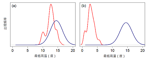
圖一 Two hypothetical examples of ensemble forecast. The red lines show the distribution of ensemble forecasts for the minimum temperature on a certain day in late January, while the blue lines show the frequency distribution of historical daily minimum temperatures in late January (the climate distribution).
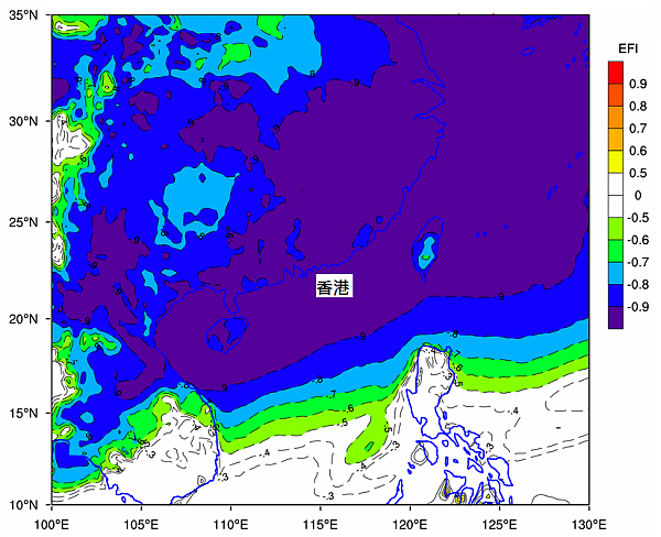
圖二 The "Extreme Forecast Index" of minimum temperatures for the period from 8 a.m. on 24 January 2016 to 8 a.m. on the following day computed based on the outputs from the Ensemble Prediction System of ECMWF on 18 January. (©ECMWF 2016)
Extended reading:
- Observatory's Blog: Let's Talk about Weather Forecasting.
- Education Resources: Does God play dice? – randomness in weather evolution。
- Zsótér, E., 2006: Recent developments in extreme weather forecasting. ECMWF Newsletter, 107, 8–17.