... winds freshening from the east later (with a few rain patches) in Weather Forecasts
During the winter and spring seasons, if the cold air from the north takes an eastern route i.e. along the coast of southeastern China, as it heads south, the monsoon usually reaches Hong Kong in the form of an "easterly surge". When the cold air impinges upon a warmer and more moist airmass, the latter will be lifted as a result of its lower density, cooling and condensing its water vapour content in the process (Figure. 1). Under suitable meteorological conditions, the leading edge of an "easterly surge" is often marked by a distinct, narrow band of clouds. Its passage will normally lead to a sudden increase in cloudiness or even rain, hence its movement is closely monitored by weather forecasters.
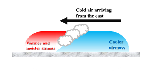
Figure 1 Schematic diagram of the lifting effect at the front edge of cold air
The evolution of local weather during an "easterly surge" on 26 January 2014 happened to be well captured by the high-resolution polar-orbiting satellite. Figure. 2 shows the arrival of a cloud band, associated with a fresh easterly airstream, over the eastern waters of Hong Kong around 2 p.m. that day. Meanwhile, wind speed recorded at Waglan Island saw a rapid rise from 2 - 3 ms-1 to about 10 ms-1.
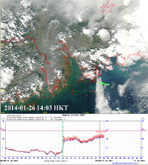
Figure 2 True colour satellite image (top) from the NASA's Earth Observing System (EOS) indicating a cloud band associated with an "easterly surge" moving across the eastern waters of Hong Kong at around 2 p.m. on 26 January 2014. A corresponding freshening of winds (bottom) was observed at the automatic weather station at Waglan Island (location highlighted by green arrow).
The cloud band associated with this "easterly surge" covered a relatively small area, being only around ten kilometres wide or less in the vicinity of Hong Kong. This is smaller than the horizontal resolution of many global and regional numerical weather prediction (NWP) models. Figure 3 shows a high resolution NWP model successfully simulated the cloud band associated with the "easterly surge" in this case. Hence, to accurately capture the weather evolution due to such fine-scale systems, high resolution modelling system would be a very useful tool.
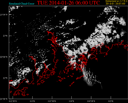
Figure 3 Cloud amount over the Pearl River Estuary (PRE) during the arrival of the "easterly surge" on 26 January 2014 as predicted by a high-resolution NWP model. According to the forecast, a north-south oriented cloud band would reach the vicinity of Waglan Island around 2 p.m. that day. The predicted distribution of clouds to the east and west of the PRE also agreed reasonably well with satellite observations (Figure 2).