Regional variations in visibility over Hong Kong
Visibility is defined in meteorology as the maximum distance that an object can be identified by un-aided eyes. It drops when light rays are absorbed or scattered by tiny water droplets, dust or other particulates suspended in the air. Hong Kong, though small in size, may occasionally see large regional variations in visibility due to localized geographic and atmospheric conditions. This can be illustrated by the following two cases.
On 17 February 2005, southerly wind prevailed over the coastal areas of Guangdong. When this moist air encountered the relatively cool underlying sea surface, the moisture condensed into tiny droplets, giving rise to fog. In the early morning, the atmosphere in the vicinity of Waglan Island was saturated with a relative humidity of 100%. Under the influence of the sea fog, the visibility over the region fell to around 300 m. In contrast to the foggy situation near the island, the visibility at Chek Lap Kok stayed above 10 km with relative humidity varying between 75% and 80%, an unfavorable condition for fog formation. The regional contrast was even greater at 8:00 am when Waglan Island and Chek Lap Kok saw visibility of 100m and 15km respectively (figure 1).
Another case occurred on 1 January 2007 when the dry northeast monsoon brought fine weather to southern China. In the afternoon, moderate east to northeasterly winds generally prevailed over Hong Kong; the visibility at the Observatory Headquarters was up to 30 km. Over the western part of the territory, near Chek Lap Kok, winds were light northwesterlies. The convergence of the localized northwesterlies and the prevailing easterlies, plus the stable atmospheric conditions associated with the inversion layer at 1 km aloft, provided a condition in which the suspended particulates could not disperse readily. Consequently, the visibility at Chek Lap Kok was reduced to 3100 m (figure 2). Real time visibility readings at various districts can be obtained from the Observatory's web page athttp://www.weather.gov.hk/wxinfo/ts/index_e_vis.htm
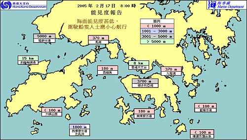
Fig.1 Visibility over Hong Kong at 8:00am on 17 February 2005. The mountain range of Lantau Island blocked the moist southerly winds, creating unfavorable conditions for fog formation at Chek Lap Kok.
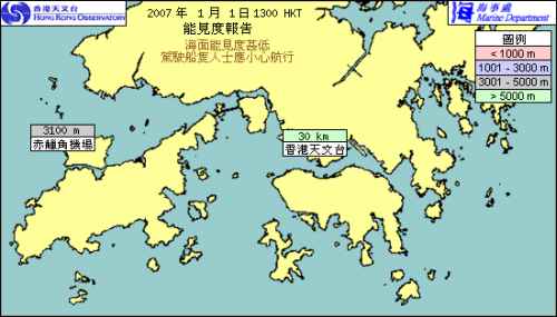
Fig.2 Visibility over Hong Kong at 1:00pm on 1 January 2007. In the vicinity of Chek Lap Kok, the light northwesterlies converged with the prevailing easterly winds, giving rise to reduced visibility.