The 2008 South China snow storm and the cold weather of Hong Kong - a retrospect
The south China snow storm in 2008
In early 2008, south China suffered from a severe snow storm. The snow storm occurred mainly in provinces like Guizhou, Hubei, Hunan and Jiangxi (Figure 1). Because of the relatively drier air mass in the north, precipitation was less in northern China than in southern China. Despite the colder temperatures, provinces in northern China was comparatively free of snow. There was extensive freezing rain in southern China (Fig.1), rendering the road surface icy and slippery, and causing traffic accidents or disruption. It also froze on power lines, significantly increased their weight and causing the power transmission tower to crash down. There were serious electricity blackouts in many cities.
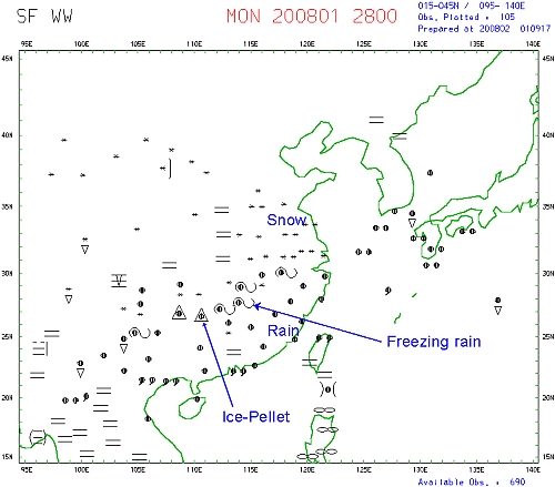
Fig.1 The weather of southern China on 28 January 2008. (The weather symbols on the weather chart were used internationally based on "World Meteorological Organization Publication No.306 Part A".)
The formation of freezing rain
The formation process of freezing rain begins when snow flakes fall from clouds at high altitudes (Fig.2). When the snow flakes fall through a layer of warm air with temperature higher than the freezing point, they completely melt and form rain droplets. As the rain droplets continue to fall and enter a layer of air with subfreezing temperatures, the rain drops do not freeze instantly but become supercooled. When the supercooled rain drops eventually reach any subfreezing object on the ground, they will freeze immediately. This kind of precipitation is called freezing rain.
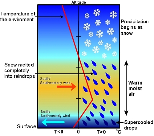
Fig.2 The formation of freezing rain (T is in degrees Celsius)
Conditions favourable for formation of freezing rain
Freezing rain usually forms when a subfreezing air stream meets with a warm air mass. By virtue of their different densities, the subfreezing cold air stream undercuts the warm air stream which is displaced aloft (Figure 2). An inversion layer will then be established. Lack of condensation nuclei in the atmosphere is also an essential condition for freezing rain to form.
How did the snow storm occur?
The extensive snow storm was related to the La Nina event, during which sea surface water over the central and eastern tropical Pacific was persistently cooler than normal. This caused the atmospheric circulation to deviate from its normal pattern, and specifically, outbreaks of cold air became more frequent. While the cold air stream spread towards the south incessantly, warm moist air originated from the South China Sea and even as far away as in the Indian Ocean was continually transported to southern China. The cold and warm air streams met over southern China and in the areas south of Chang Jiang, causing long period of precipitations including freezing rain and snow. As time progressed and the snow storm continued to unfold, a calamity was in its making.
Why was the weather cold and cloudy in Hong Kong during the same period?
The formation of the snow storm of southern China bears some common features with the cold and cloudy weather in Hong Kong starting mid-January 2008. The upper air temperature and wind direction over Hong Kong on 29 January 2008 would provide the clues. An inversion appeared below 800m (Fig.3) over Hong Kong, where the temperature increased with height. Hence, it was warm and moist near the top of the inversion but cold below the inversion. Figure 4 shows the winds below 800m over Hong Kong. Warm and moist southerly winds appeared aloft while cold northerly winds appeared at low altitudes. In fact, the inversion was more or less a permanent feature during the spell of cold and cloudy weather in Hong Kong.
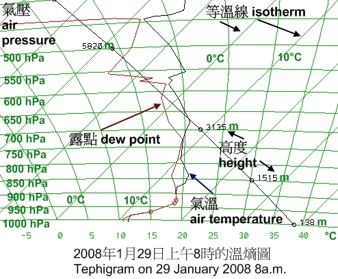
Fig.3 An inversion appeared below 800m above Hong Kong. (It was warm and moist in the upper part of the inversion and cold below.)
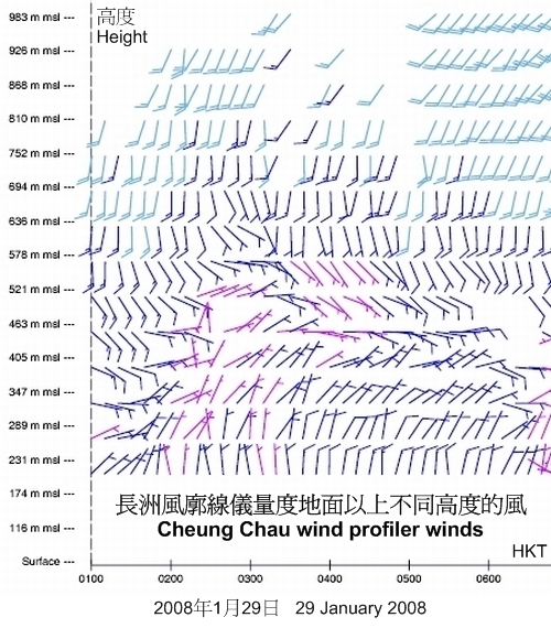
Fig.4 Northerly and southerly winds appeared at different altitudes. (Southerly winds in higher altitudes and northerly winds in lower altitudes.)
Why was there no freezing rain in Hong Kong?
There was no freezing rain in Hong Kong because the ground temperature was higher than the freezing point (Fig.5). Let’s take the atmospheric temperature profile over Hong Kong on 29 January 2008 8a.m. (Fig.3) as an illustration. The atmospheric temperatures below 4000m were well above the freezing point.
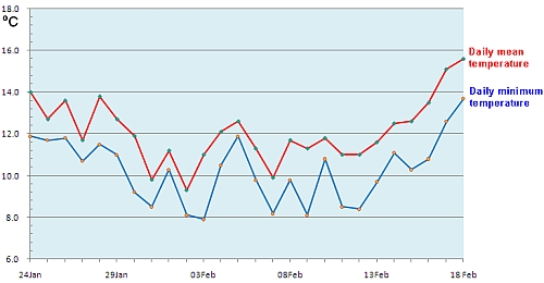
Fig.5 Daily mean (red) and minimum (blue) temperatures at Hong Kong Observatory
The longest cold weather warning of Hong Kong
Although there was no freezing rain in Hong Kong, the weather was cold with some rain. The cold weather warning was in force continuously for 594.5 hours and spanned 26 days during the period from 24 January 2008 to 18 February 2008. This is the longest warning since the cold weather warning service was launched in 1999. During the period in which the cold weather warning was in force, the minimum daily temperatures of Hong Kong were mostly below 12 degrees Celsius (Fig.5).
References
- 拉尼娜是雪災"罪魁禍首" 至少持續至春末 - 中國評論新聞網(Chinese only)
- Press release (13 February 2008), Hong Kong Observatory
- 2008年初華南沿岸地區持續寒冷的天氣分析和預報技巧 - 唐宇煇、李月嬋 & 陳世倜,香港天文台,2009年第23屆粵港澳氣象科技研討會 (Chinese only)