How is the Hiking Trail Weather Service made?
How is the Hiking Trail Weather Service made?
OR Ming-keung and CHENG Yuen-chung
September 2020
In early 2020, the Observatory collaborated with the Agriculture, Fisheries and Conservation Department (AFCD) to provide weather information at various popular hiking hotspots. Upon scanning the weather information QR code located at the information board of the country parks, hikers can obtain the latest weather information, including 2-hour rainfall and 1-hour lightning nowcast of nearby hiking routes (Figure 1). This service is different from the conventional 9-day weather forecast that provides a summary of the daily weather conditions. The new Hiking Trail Weather Service provides users with hourly automated weather forecast during the hiking trip, and the forecasts are refined to more than 60 major hiking trails in Hong Kong.
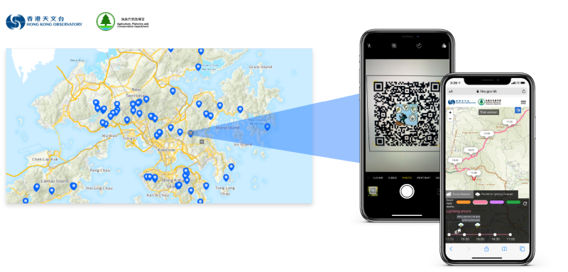
Figure 1. Weather information for the hiking trails in Hong Kong.
To provide the latest weather information for hiking routes near the notice board with QR codes in country parks, we have to find out all the possible hiking routes nearby reachable in two hours. To find these routes, we need to first understand the hiking route data. There are more than 60 hiking routes in the dataset, and each route consists of a number of short straight line segments. Each segment has the coordinates of the start and end points; and each route contains information such as its length and the approximate hiking time required. However, there is no information on the relation between different routes in the dataset like overlapping sections, which is important for locating all possible hiking routes. Taking the segment of the hiking routes on Lantau Island near Pak Kung Au as an example, we find that there is an overlap between the Phoenix Trail and the South Lantau Country Trail on map (Figure 2(a)). As there is no relationship between these two routes as seen from the raw data of the hiking route dataset, the possible routes could only be two. However, if the overlapping sections are considered, there will be more than two possible routes (For instance from the South Lantau Country Trail to the Phoenix Trail in Figure 2(b)).
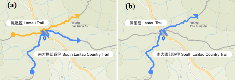
Figure 2
With the information of overlapping sections, we are able to identify all possible hiking routes which is reachable within two hours near the QR code. To find all possible routes, one of the methods is to draw all the routes and the location of the QR code on the map, identify all the routes which are reachable within two hours near the QR code, and then count the number of the possible routes while considering the overlapping sections. The aforementioned method is feasible, yet not efficient. In particular, when there are changes or new additions to the hiking routes, it needs manpower to re-calculate. To automate this procedure, we can employ some tools in Graph Theory to find all possible hiking routes reachable within two hours.
Let’s take the aforementioned Phoenix Trail and the South Lantau Country Trail near Pak Kung Au as an example again. Since there is no relationship between the two routes in the raw data, they are expressed in Graph by two non-intersecting lines (Figure 3(a)). If overlap is considered, there will be more than two possible routes (Figure 3(b)). When we draw the Phoenix Trail and the South Lantau Country Trail near Pak Kung Au on a map (Figure 4), it will take some time to find out the possible routes manually. However, it is easy to figure out the number of possible routes automatically if we use a graph to express (Figure 5). Therefore, after converting the data into a graph and using algorithm in graph theory, all the routes that are reachable within two hours can be calculated automatically.
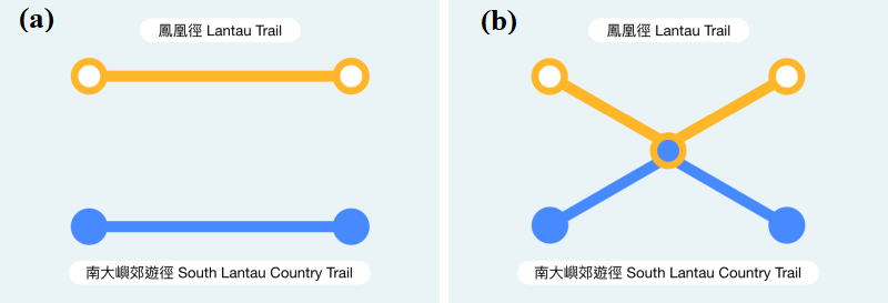
Figure 3. Two non-intersecting routes in (a) becoming more than two possible routes in (b) after considering overlap of routes.
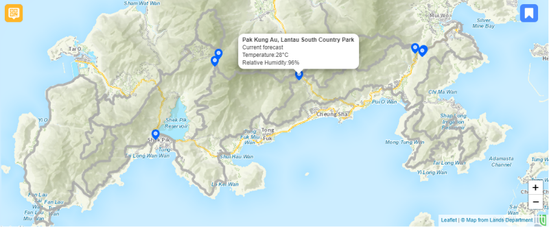
Figure 4. Hiking trails are indicated by grey lines.

Figure 5. All possible routes expressed in the form of Graph.
After identifying the possible routes, the "Hiking Trail Weather Service" can be made by putting together the automatically generated rainfall and lightning forecast data.
Through the above brief introduction, we hope one can understand more about how the "Hiking Trail Weather Service" is prepared. Before hiking, please visit the "Hong Kong Hiking Trail Weather Service" webpage to plan your trip, and scan the weather information QR code on the information board of the country parks during your hiking trip to get the latest weather information.