3D Cloud Observation
3D Cloud Observation
TSANG Moon-tong and Terence KUNG
July 2022
The height and amount of clouds are two important elements of weather observation. In particular, when the aircraft lands, it is necessary to know at what altitude the runway can be seen beneath the clouds for carrying out relevant checks and corrections. Also, when the Government Flying Service (GFS) performs search and rescue operations, the height and amount of cloud will also be considered in determining the appropriate rescue plan.
At the Central Forecasting Office in Tsim Sha Tsui, the Weather Observer of the Observatory relies mainly on nearby landmarks, such as the heights of buildings or mountains, to estimate the height of clouds in their vicinity. Estimation can best be made when the cloud is above the landmark. Taking Figure 1 as an example, with reference to the heights of the peaks on Lantau Island and the location of cloud shadows, it is estimated that the cloud base height was about 2,700 feet. When observing clouds, we should also note that objects at the same height would appear lower when they are further away from the observer, and higher when they are closer to the observer, as the visual effect shown in Figure 2.
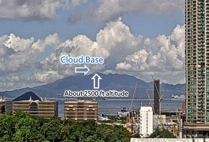
Figure 1 : View of Lantau Island from Tsim Sha Tsui
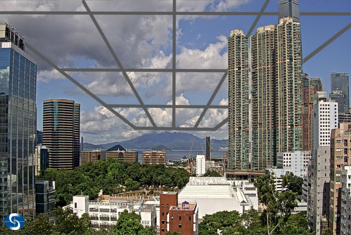
Figure 2 : The planes formed by the straight lines in the figure are of the same height
The ceilometer measures the heights of cloud base above the ground. It transmits laser pulses vertically from the ground into the atmosphere and then measures the time taken by the pulses to return upon reflection by small water droplets in the clouds. Without the help of the ceilometer, besides using naked eyes, i.e. visual cloud observation, we can also use other information as the supplement:
1. Satellite imagery – We can use infrared and true colour satellite imagery together to roughly estimate the cloud amount near Hong Kong and the distribution of high, medium and low clouds. Since infrared light cannot penetrate through cloud layers, the infrared radiation emitted from a cloud that can be measured by satellite is from the cloud top. Its wavelength will depend on the cloud top temperature, hence the altitude of cloud top can be estimated. Taking Figure 3 as an example, the vicinity of Hong Kong was covered by medium and high clouds. Top of high clouds are cooler than that of low clouds and appears in brighter white colour in infrared images, but the colour displayed in the true colour image will be lighter. Meanwhile, it can be seen clearly from the true colour image in Figure 3 that there were some small low clouds to the south of Hong Kong. This is because true colour satellite images have higher resolution and can display more detailed cloud structure. However, low clouds are harder to see in infrared images.
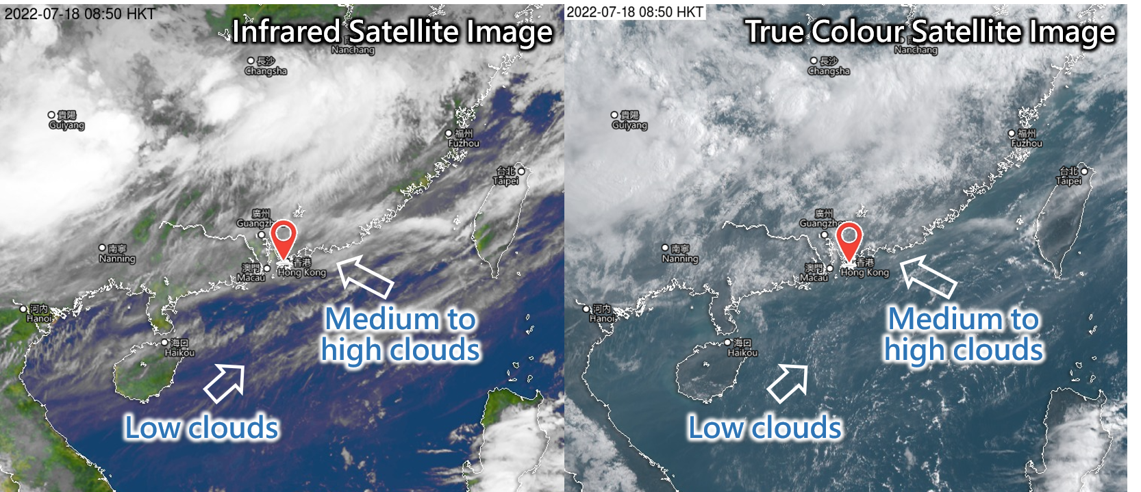
Figure 3 : Infrared (left) and true colour (right) satellite images
2. All Sky Imager – We can use all sky images to easily grasp the approximate cloud amount as well as the distribution of high, medium and low clouds without looking up at the sky. Low clouds have a darker cloud base, whilst medium to high clouds are in brighter white colour. Taking Figure 4 as an example, the cloud amount of low clouds is about 3/8, and that of high clouds is about 1/8.
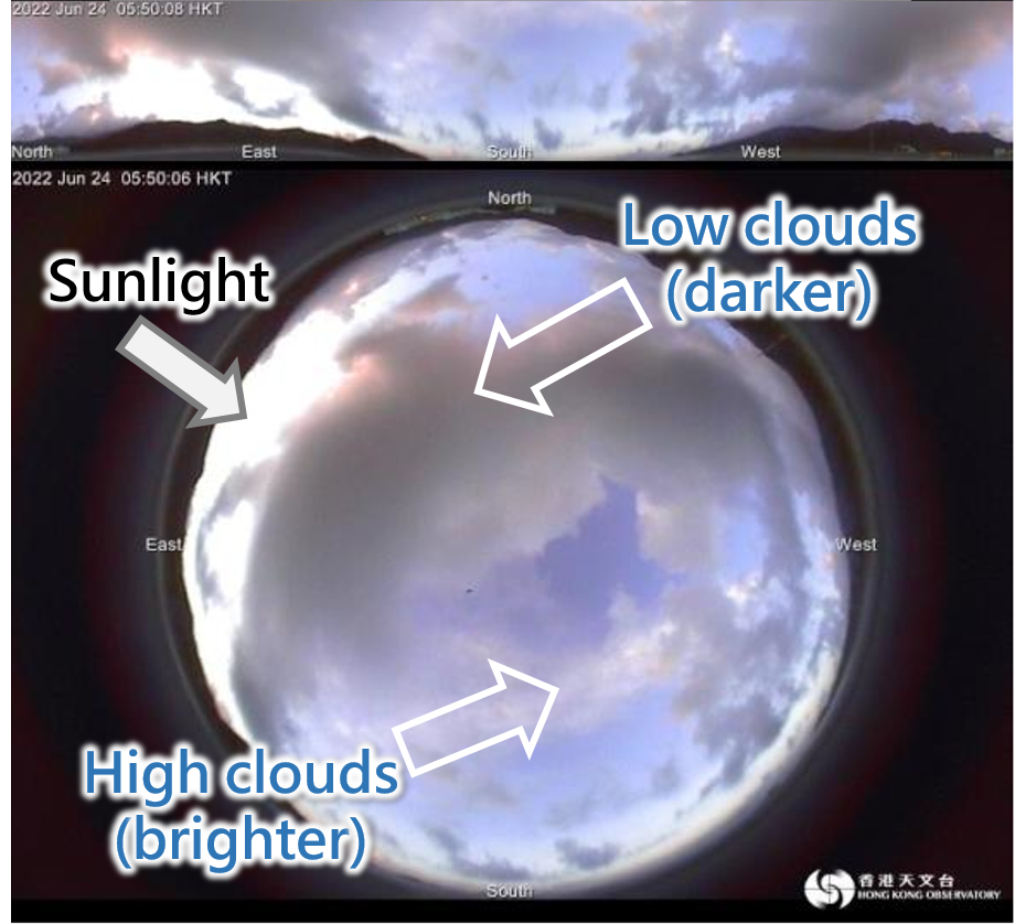
Figure 4 : All sky image at Shek Pik
3. Weather Photos – We can use weather photos from higher observation points to estimate cloud base heights. Taking Figure 5 as an example, looking to the southwest from the Tai Mo Shan weather station, it can be estimated that the cloud base height is about 3,000 feet, slightly lower than the height of the weather station (3,150 feet). We can even use the directions and elevation angles of different observation points to mutually verify the distance and height of the same cloud.
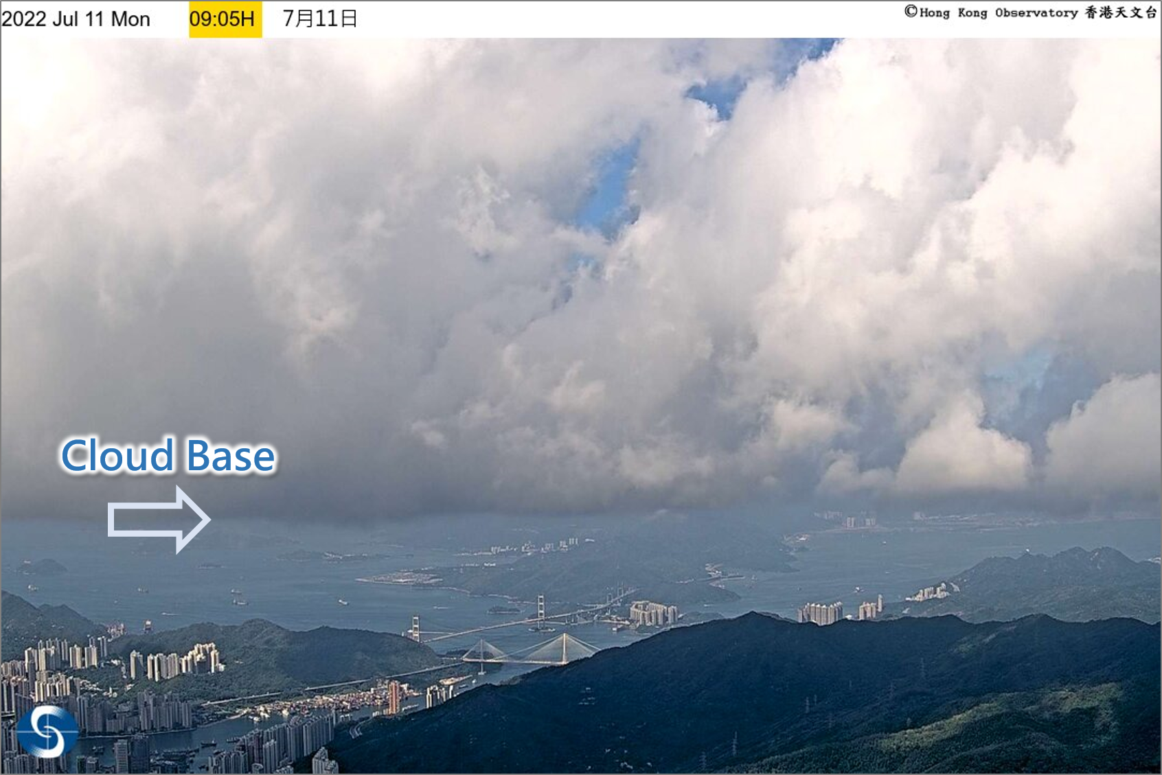
Figure 5 : Looking southwest from the Tai Mo Shan weather station
4. Real-time flight information – If you see an aircraft flying under the cloud or passing through the clouds, you can immediately use those webpages or mobile apps which provide real-time flight information to check the flight altitude of the aircraft at that time to help analyse the approximate cloud base height. In the example in Figure 6, the aircraft was flying at an altitude of 1,350 feet (Figure 7). From this, it can be estimated that the cloud base height at the location indicated by the dashed line was about 1,500 feet.
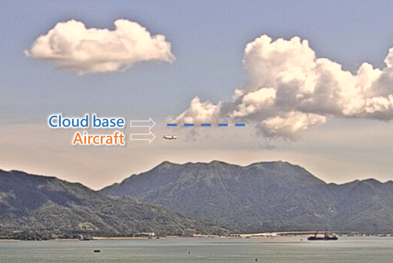
Figure 6 : Looking towards Lantau Island from Tai Lam Chung
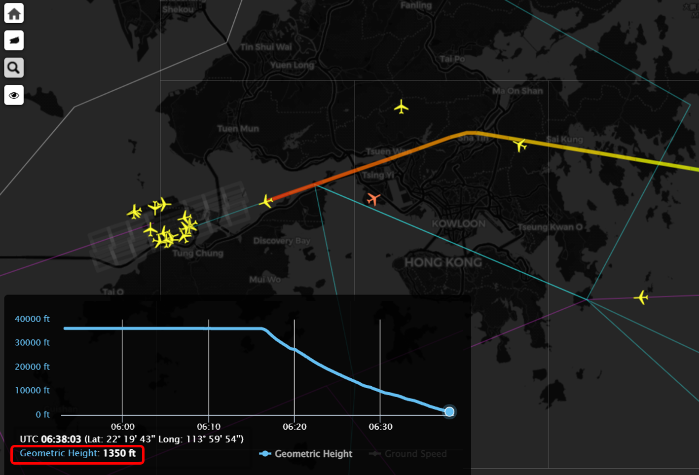
Figure 7: The flight altitude of the aircraft was 1,350 feet (Source: Flight information provided by the Observatory for reference by aviation meteorologists)