Arcus Cloud
Arcus Cloud
YEUNG Pui-yi
November 2015

Figure 1 Photo by Lau Hon Ming
Have you ever seen this kind of astonishing clouds before? It is called “arcus cloud” or “shelf cloud”. It is a rare type of accessory cloud of cumulonimbus or cumulus congestus, in gray color appearing in horizontal roll or wedge shaped form, just like a shelf supporting a storm. The edging of extensive arcus clouds usually portends an approaching severe storm.
Arcus cloud normally develops when cool air from strong downdraft, namely the gust front, associated with mature cumulonimbus cloud sinks rapidly to the ground. This forces the surrounding warm moist air to rise up along the gust front and then cool and condense, forming arcus cloud at the bottom of the cumulonimbus cloud and in the direction of cloud movement. Arcus cloud sometimes only lasts for a short period of time.
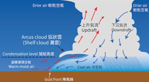
Figure 2 The schematic diagram shows the formation of arcus cloud.