What is Fujiwhara Effect?
What is Fujiwhara Effect?
HUNG Fan-yiu
'Fujiwhara effect' is named after Dr. Fujiwhara of Japan who performed a series of experiments and observations on water vortices from 1921 to 1923. He discovered interaction between two cyclonic vortices when they were close to each other. The vortices would rotate cyclonically about an axis connecting their centres. The two vortices also had a tendency to approach each other and then merge together.
In meteorology, 'Fujiwhara effect' applies to the interaction of two tropical cyclones. In general, two tropical cyclones may start to affect each other when the distance between them is around 12 latitude degrees (about 1350 kilometers). When this occurs, The tropical cyclones will rotate around one another in a counter-clockwise direction (in Northern Hemisphere) about their geometric centre. The centre needs not be the middle of the axis. The stronger cyclone tends to have a dominant effect on the track of the weaker one. The interaction will end when: there is a stronger influence of a large scale weather system from outside, one of the tropical cyclones weakens or the two cyclones merge. Research by the Observatory shows that if the distance between the two tropical cyclones is 1200 kilometers or more, the chance of merging is slim.
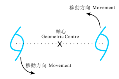
Figure 1: The interaction of two tropical cyclones.
Figure 2 and 3 show the tracks of tropical cyclones Wukong and Sonamu in August 2006. It is evident that Wukong had a counter-clockwise movement during 14 and 15 August under the influence of Sonamu.
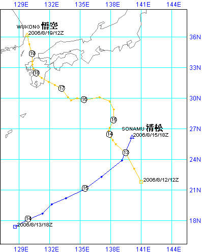
Figure 2: Tracks of tropical cyclones Wukong and Sonamu in August 2006. The time shown in the figure is Coordinated Universal Time.
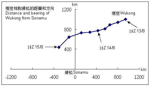
Figure 3: Wukong moved counter-clockwise relative to Sonamu.
Tropical cyclones appear in the Northwestern Pacific every summer. It is not rare to have two tropical cyclones there at the same time. When 'Fujiwhara effect' occurs, we may see changes in the tropical cyclones' movement and speed. This will increase difficulties when their tracks are forecast.
References:
[1] 《2000年在西北太平洋上雙熱帶氣旋相互作用實例的探討》,陳營華、何嘉玲,香港天文台,2001年
[2] 《颱風講義》,丁一滙,國家海洋環境預報研究中心,1985年
[1] 《2000年在西北太平洋上雙熱帶氣旋相互作用實例的探討》,陳營華、何嘉玲,香港天文台,2001年
[2] 《颱風講義》,丁一滙,國家海洋環境預報研究中心,1985年