Tracking by Actual Observations
Tracking by Actual Observations
CHAN Chik-cheung
December 2010
Apart from satellite and radar, surface observations are also useful information in locating tropical cyclones, especially for those weaker ones whose centres are not well defined on satellite pictures.
Both ship and land observations in the vicinity of a tropical cyclone are useful. The inflow angle method is the most commonly used method. Here, the basic assumption is that the tropical cyclone is a circularly symmetric weather system. The principle is that because of friction with surface, the air inside the circulation of the storm flows at an inflow angle towards the centre of the tropical cyclone. The inflow angle ranges from 15 to 30 degrees and is loosely taken to be 20 degrees most of the time.
The method is, with a minimum of three surface wind observations, (1) to draw a line making an inflow angle with the direction of the surface wind observation, (2) to draw a line perpendicular to the line in (1), and the centre of the tropical cyclone is at the centre of the polygon bounded by lines constructed by (2).
However, this method cannot always be used as ship observations are scarce over the ocean and may not be available in the vicinity of tropical cyclones. In applying this method, the wind observations must be used with care as they may be affected by other pressure systems such as the northeast or southwest monsoon.
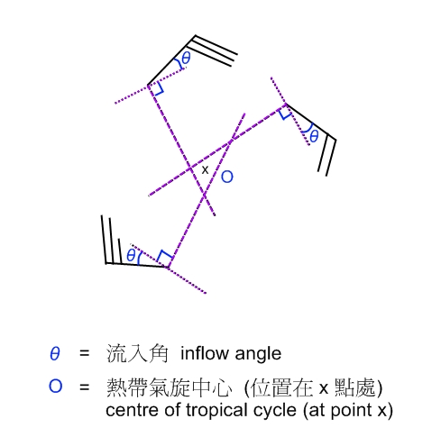
Figure 1. Locating tropical cyclone using the inflow angle method