“Rapid Intensification” of Tropical Cyclones
"Rapid Intensification" of Tropical Cyclones
WONG Sze-wa, LUI Yuk-sing
June 2025
In the weather bulletins issued by the Hong Kong Observatory, it is sometimes mentioned that a tropical cyclone underwent a stage of “rapid intensification”. But what exactly do we mean by that?
First, the Observatory classified tropical cyclones into six categories by the maximum 10-minute mean sustained wind speed near its centre[1]. From the weakest to the strongest, the six categories are Tropical Depression, Tropical Storm, Severe Tropical Storm, Typhoon, Severe Typhoon and Super Typhoon.
Meteorologist D'vorak summarised a climatological model of tropical cyclone growth based on satellite observations[2]. According to the model, the average growth rate of a tropical cyclone is about an increase in “T value” of 1.0 per day. Assuming an area of low pressure develops into a tropical depression (T value of about 1.5) on the first day, on average it will strengthen to near tropical storm strength (T value of about 2.5) on the second day, develop into a severe tropical storm (T value of about 3.5) on the third day, and so on.
If a tropical cyclone intensifies faster than the model normal, then it may be described as “rapidly intensifying”. Although there is currently no globally consistent or authoritative indicator for “rapid intensification” among academia or meteorological centres, one of the more commonly used indicators is: a 24-hour increase in the maximum sustained wind speed near the centre of at least 55 km/h.
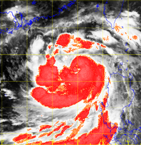
Taking Super Typhoon Yagi[3] which affected Hong Kong in September 2024 as an example, when Yagi entered the northern part of the South China Sea on 3 September, the convective cloud structure was still relatively loose. However, under favourable conditions such as very warm sea water[4] and weak vertical wind shear[5], Yagi later rapidly intensified from a severe tropical storm into a super typhoon. Within 24 hours (5 a.m., 4 September - 5 a.m., 5 September), the estimated maximum sustained wind speed near its centre rose significantly from 110 km/h to 205 km/h, with an increase of 95 km/h.
| Date and time (HK Time) |
3 September 2024 5 a.m. |
4 September 2024 5 a.m. |
5 September 2024 5 a.m. |
|---|---|---|---|
| Deep convection satellite imagery | 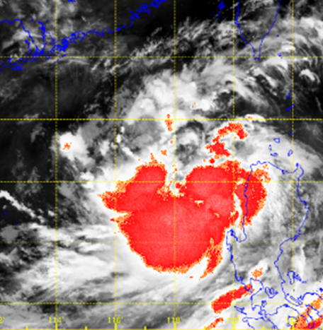 |
 |
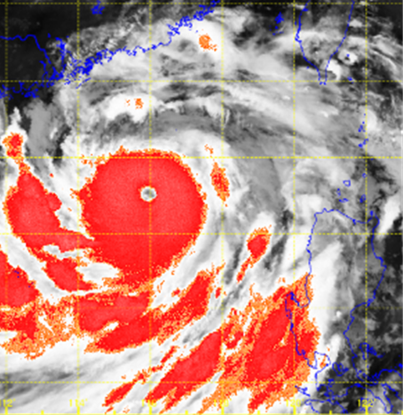 |
| Intensity | Tropical Storm | Severe Tropical Storm | Super Typhoon |
| Estimated maximum sustained wind speed near its centre |
75 km/h | 110 km/h | 205 km/h |
Table 1 Comparison of Yagi's deep convection satellite imagery and intensity from 5 a.m. on 3 September to 5 a.m. on 5 September, 2024. The base picture is an infra-red image where clouds with higher cloud top will appear brighter and regions affected by deep convection weather are highlighted in red. [The satellite imagery was originally captured by Himawari-9 Satellite of Japan Meteorological Agency.]
According to the Working Group I contribution to the Sixth Assessment Report (AR6) “Climate Change 2021: The Physical Science Basis”[6] released by the United Nations Intergovernmental Panel on Climate Change (IPCC), it is likely that the global frequency of rapid intensification events of tropical cyclones has increased over the last four decades. This change cannot be explained by natural variability alone (medium confidence). For more information about the impacts of climate change on tropical cyclones, please refer to the Observatory’s webpage.
References:
[1] Tropical Cyclone Classification.
[2] Tropical Cyclone Intensity Analysis Using Satellite Data.
[3] Report on Super Typhoon Yagi (2411).
[4] Why do Tropical Cyclones Require Sea Surface Temperatures of 26°C to Form?
[5] How does vertical wind shear affect the development of Tropical Cyclone?
[6] Climate Change 2021: The Physical Science Basis. Contribution of Working Group I to the Sixth Assessment Report of the Intergovernmental Panel on Climate Change. Chapter 11.7.1.