How to measure cloud top height from a meteorological satellite?
How to measure cloud top height from a meteorological satellite?
TAM Hiu-ching
January 2019
How high a cloud can grow depends on the atmospheric conditions. For example, clouds developed under unstable atmosphere normally grow high up to the upper troposphere. Knowing the cloud top height helps us understand the state of the atmosphere. Meanwhile, knowing the height of the top of a cloud is also valuable to pilots for making decision on whether to fly around or over a convective cloud. Observing the cloud from the above using meteorological satellite allows us to estimate the cloud top height. But how is that done?
In Physics, we understand that all object will emit electromagnetic radiation and the amount of which will depend on its own temperature. By measuring the radiation of specific wavelengths emitted from the top of a cloud, we are able to estimate the corresponding temperature according to the Planck's law[1]. For example, infra-red radiation emitted from a cloud can be measured by the infra-red sensor on a geostationary meteorological satellite. Since cloud is opaque to that infra-red frequency, the temperature measured by the sensor is very close to that at the cloud top. After obtaining the cloud top temperature, the cloud top height can be derived from the temperature vertical profile, which in turn can be retrieved from the measurement using the upper air sounding system or estimated from the numerical weather prediction model. Figure 1 shows a schematic diagram indicating how the cloud top height from infra-red measurements is determined.
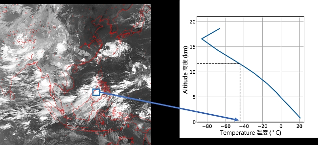
Figure 1 Figure on the left shows the Himawari-8 infra-red satellite image. The cloud top height of the region marked by the blue square can be derived by mapping the cloud top temperature to the corresponding altitude from the vertical temperature profile on the right (see dotted line).
There are also other polar-orbiting satellites equipped with lidar which can directly measure cloud top height. A lidar transmits laser pulses which are scattered backward by the particles in the cloud like water droplets and ice particles. The backscattered pulse is collected by the instrument onboard of the satellite. By measuring the time lapse between transmitting a laser pulse and receiving the pulse backscattered by the cloud top, we can calculate the height of the cloud top. For example, one of the missions of the Cloud-Aerosol Lidar and Infrared Pathfinder Satellite Observation (CALIPSO) satellite[2] is to measure the vertical structure of clouds using its onboard lidar (Figure 2).
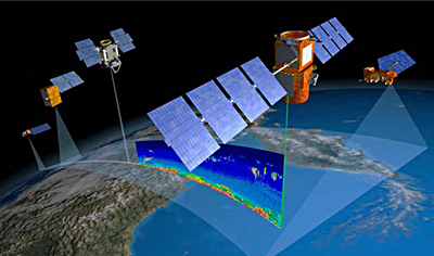
Figure 2 CALIPSO CALIPSO satellite (Credit: NASA CALIPSO)