What is a Meteorological Satellite?
What is a Meteorological Satellite?
Meteorological satellites carry sensors that are pointing towards the ground, enabling them to have bird eye view of the globe from the space. There are two types of meteorological satellites characterized by their orbits. They are geostationary satellites and polar-orbiting satellites (Figure 1).
As the name suggests, a geostationary satellite is stationary relative to the earth. That is, it moves above the equator at the same rate as the earth's rotation so that all the time it is above the same geographical area on the earth. In this manner, it is capable of taking cloud images of the same area continuously, 24 hours a day. As it is some 35,800 kilometres from the earth, it is capable of taking cloud pictures covering part of the whole globe.
Polar-orbiting satellites are low-flying satellites circling the earth in a nearly north-south orbit, at several hundred kilometers above the earth. Most of them pass over the same place a couple of times a day. As they operate at a distance closer to the earth, they are only capable of taking cloud images of a limited area of the earth each time. Compared with geostationary satellites, polar-orbiting satellites offer fewer and smaller cloud pictures. However, the advantage is that the cloud pictures obtained are of much higher resolution.
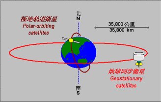
Figure 1 - Orbits of geostationary satellites and polar-orbiting satellites.