Can Earthquakes be Predicted?
Can Earthquakes be Predicted?
WONG Cheuk-yiu Lillian and LAM Ching-chi Queenie
May 2024
Earthquake is one of the natural disasters that can cause vast impacts without any precursors. When an earthquake occurs, energy is released from the focus, transmitting in the form of seismic waves with different frequencies and amplitudes (or strengths) in all directions. The more energy is released, the larger the magnitude is. An increase of 2 in magnitude represents 1,000 times more energy released. Statistics reveal that earthquakes directly or indirectly caused over 780,000 deaths worldwide from 2000 to 2023[1], more than any other natural disasters. Given current scientific capabilities, seismologists can only estimate the probability of significant earthquakes in a certain area within a certain period of time based on observational data including historical earthquake events, geophysics, geochemistry and geological properties[2]. Seismologists can also estimate the locations at which strong earthquakes may occur in the future and the corresponding possible maximum earthquake magnitude. Although there are studies utilizing technologies such as big data and artificial intelligence to forecast earthquake risk in different time scales, the exact timing, location and magnitude of an earthquake (collectively referred to as the "three key parameters of an earthquake") cannot be predicted yet. In the light of this, earthquake authorities around the world are actively researching and promoting the use of dense seismograph network in enhancing monitoring capability and striving to disseminate rapid earthquake messages to affected members of the public before the arrival of destructive seismic waves in order to protect lives.
Speed racing of earthquake early warning against seismic waves
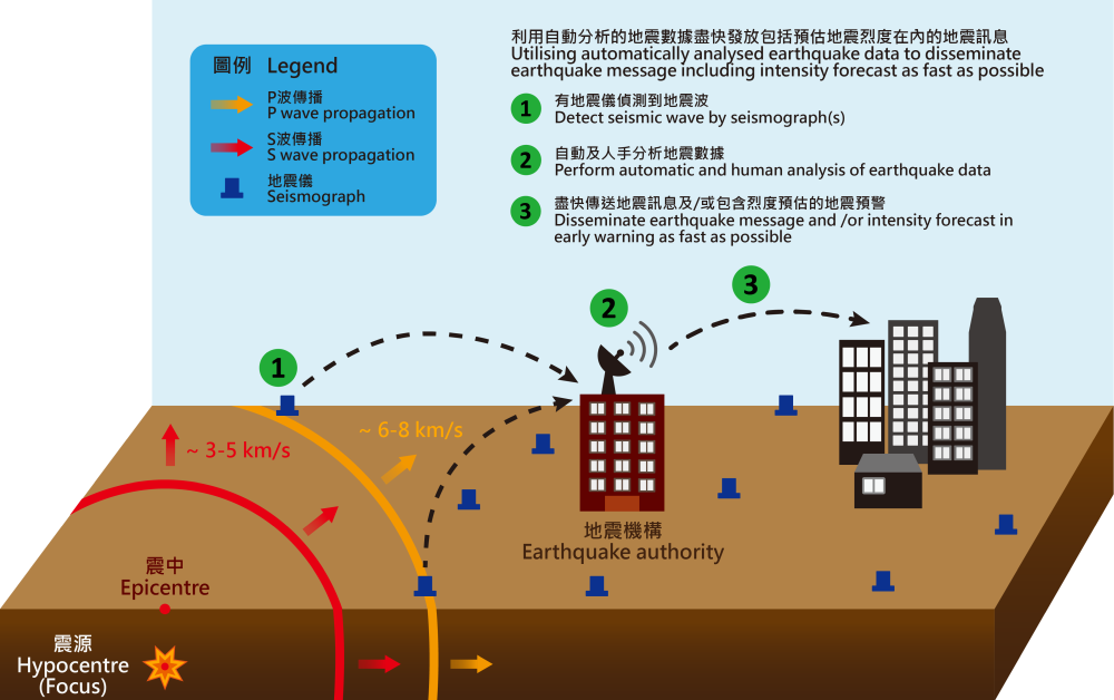
Different types of seismic waves (P waves, S waves and surface waves) were briefly introduced in the article “How to Interpret Seismic Parameters?”. As mentioned in the article, their speeds of propagation differ, and hence the seismographs on the ground record their different arrival times which can be analysed from these time series data. P waves (travelling at around 6 to 8 km per second) are faster than S waves (travelling at around 3 to 5 km per second), while the energy carried by S waves is several to dozens of times of that of P waves (Figure 1). The surface waves that follow have even larger amplitudes and thus carry more energy. When an earthquake occurs, the seismograph network with high-speed data transmission and densely distributed equipment transmits the P waves detected near the epicentre to the earthquake authority. The three key parameters of earthquakes will be rapidly determined based on the P waves detected. By making use of the difference in the wave speeds of different types of seismic waves and mathematical models, the time of arrival of seismic waves (mainly S waves) and the severity of ground shaking (i.e. “earthquake intensity”) in surrounding areas will be estimated. For relatively distant and significant earthquakes, those earthquake authorities with proper infrastructures may have the opportunity to issue earthquake early warning by making use of electromagnetic waves (with wave speed of around 300,000 km per second) and high-speed communications a few seconds to some ten seconds before the arrival of more destructive seismic waves to alert potentially affected people to take timely precautionary actions with a view to reducing the risk of casualties.

Figure 1 Schematic diagram illustrating the ground shaking induced by P waves and S waves.

Figure 2 Schematic diagram explaining how an earthquake authority can quickly disseminate earthquake message and/or early warning.
Why does earthquake early warning require a dense seismograph network with high-speed data transmission? Firstly, after one or some seismographs detect P waves, the associated waveform data are transmitted in real time via high-speed communications to the earthquake authority for immediate automatic analysis and determination of epicentre. This allows the authority to possibly disseminate at its earliest earthquake messages ahead of the seismic waves. Secondly, the transmission speed of the earthquake messages and the accuracy of the estimated epicentre and magnitude depend on the design and density of the seismograph network. The reason behind is not difficult to understand. Seismic waves propagate outwards from the focus in all directions. If there are seismographs near the hypocentre, seismic waves can be detected as quickly as possible, naturally gaining more time to transmit the earthquake message. Additionally, while processing more seismic waveform data over a short period of time will pose heavier loading to the automatic earthquake analysis system, the estimated three key parameters and intensity of an earthquake will be more accurate, reducing the chance of false alarms.
Building a dense earthquake monitoring network, developing further real-time earthquake monitoring techniques and enhancing the application of advanced communication technology can help strengthen earthquake information service, but it is increasingly difficult to find suitable locations for set up of seismic stations in a well-developed city. Once a seismograph network is built, sufficient manpower and resources are needed to maintain round-the-clock operation of the network. Besides, current technology also has certain limitations. Firstly, there exists “blind zones” in which rapid earthquake message cannot serve its warning purpose. These are areas very near the epicentre where S waves are likely to arrive before an earthquake message can be received. The blind zones are normally within some 20 km from the epicentre. The longer it takes to disseminate the message, the larger the area of blind zones will be. However, there is a trade-off between the dissemination speed and accuracy of the estimated location and magnitude of the earthquake. When seismographs are affected by non-earthquake factors such as human factors, weather, equipment malfunctions and etc. bringing noise, false alarm may occur. In addition, earthquake intensity is estimated by using statistical models which require seismic parameters computed based on the data available at the time as input. Both the accuracy of the intensity model and the amount of seismic data used will affect the error of the estimates. Lastly, seismic waveforms will also become complicated when there are frequent aftershocks, hindering the determination of the arrival time of P waves, and thus the dissemination of rapid earthquake message or early warning.
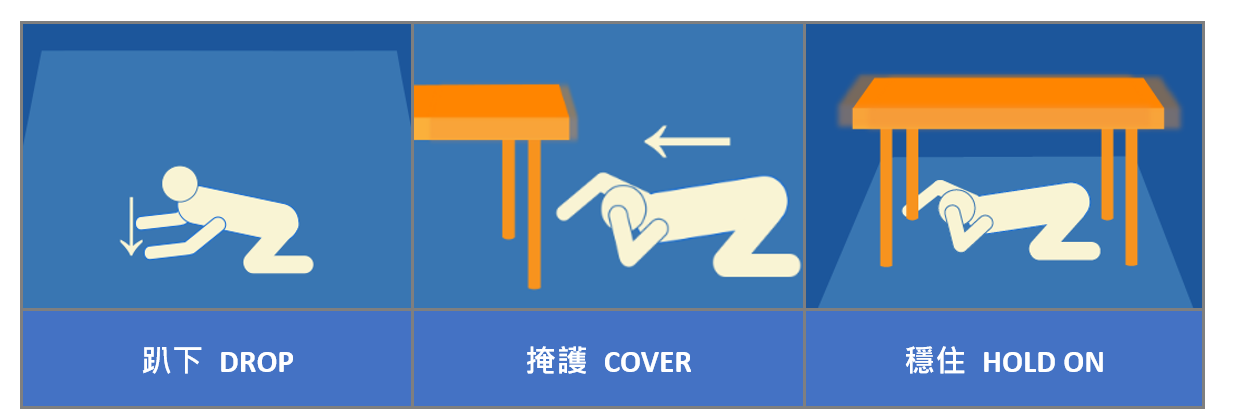
Currently, earthquake early warning is available in China, Japan[3], Mexico and the west coast of the United States to alert local residents who may be considerably affected. After these messages are transmitted to public utilities, they can be used to formulate decision plans for slowing down moving trains, controlling lifts, suspending machinery operations or surgeries, etc. to ensure people safety. Hong Kong is not located within an active seismic zone and is far away from the periphery of tectonic plates, about 600 km away from the nearest location. The chance of a major earthquake is very low. If the epicentre is in Hong Kong, the seismic waves will have spread throughout Hong Kong within some 10 seconds. Even if using an automatic method to issue earthquake early warning cannot serve the purpose of the early warning effect. Moreover, according to the Observatory’s records, locally felt earthquakes caused by an earthquake in the territory in the past 40 years or so have all been minor and occurred only occasionally (from 1979 to March 2024, only 9 weak earthquakes with magnitudes ranging from 1.4 to 3.1 occurred). The intensity was V (five) or below on the Modified Mercalli Intensity Scale, and only people near the epicentre could feel the ground shaking. Weak earthquakes have no impact on general building structures and the public do not need to take response actions. As such, earthquake early warnings would have no practical effect in these cases. For those earthquakes with epicentre outside Hong Kong, as Hong Kong is situated at the south China coast, seismic data outside Hong Kong, especially over data-sparse sea areas to the south, are not dense enough. This inherent limitation makes the Observatory very difficult to implement an effective earthquake early warning system to give early warnings to the public before the occurrence of significant earth tremors. Nevertheless, you are reminded to keep calm and note 3 key points when you encounter a strong earthquake: drop, cover and hold on (Figure 3).

Figure 3 Three key points-to-note when you encounter a strong earthquake.
References:
[1] Emergency Events Database (EM-DAT), The International Disaster Database, Centre for Research on the Epidemiology of Disasters (CRED), Brussels, Belgium.
[2] “Can You Predict Earthquakes?”, U.S. Geological Survey
[3] “Earthquakes and Tsunamis — Observation and Disaster Mitigation”, Japan Meteorological Agency, 2023