A Ground-breaking Tidal Story
A Ground-breaking Tidal Story
WONG Wing-tak
July 2011
On 11 March 2011, a magnitude 9 mega-earthquake in the seas east of Honshu, Japan triggered a damaging tsunami that destroyed many towns and villages along the north-eastern coast of Honshu. The number of people dead or missing was up to 23,000. TV audience who watched the video clips on tsunami slamming the coastline were stunned by the powerful and relentless waves, and many were overwhelmed by the subsequent Fukushima nuclear crisis. We may ask, "Would Hong Kong be hit by a tsunami of a similar scale?"
As a matter of fact, the risk of tsunami in Hong Kong is far lower than that in Japan. Japan is located on the circum-Pacific seismic belt, near the boundaries of major tectonic plates including the Eurasian Plate, Pacific Plate, and Philippine Sea Plate1, where big earthquakes and tsunamis recur from time to time. The area devastated by this tsunami had been hit by more one tsunami event in the past one hundred years or so, including the 1896 Meiji Sanriku Tsunami which killed 30,000 people and the 1933 Showa Sanriku Tsunami which also claimed 1,500 lives. On the other hand, Hong Kong is located more than 600 kilometres away from the circum-Pacific seismic belt and not lies within seismically active region. There has never been a destructive tsunami near Hong Kong in recorded history.
China is an ancient civilization. A wealth of valuable earthquake and tidal events has been put on historical records. According to earthquake catalogues compiled by experts from the Chinese Academy of Sciences, Earthquake Administration, and Academy of Social Sciences, earthquakes that might have generated tsunamis with tsunami-like damage records along the coast of south-eastern China and Taiwan included the magnitude 7½ earthquake at Quanzhou, Fujian in 1604, magnitude 7½ earthquake at Qiongshan, Hainan in 1605, and a damaging earthquake at Keelung, Taiwan in 1867. Earthquakes that were linked to tsunami stories but with no records of tsunami-like damage included the earthquakes at Tainan, Taiwan in 1661, and Jiayi, Taiwan in 1792, and the magnitude 7.3 earthquake at Nan'ao, Guangdong in 1918. There were other tsunami stories where no earthquake was recorded. These included descriptions of flood tides at Chaoyang in 1076, 1640 and 1641 and a legend of tsunami at Gaoxiong, Taiwan in 1782. These events might be related to spring tides or storm surges. For example, there were no records of earthquake or tsunami in Taiwan in 1782 but a report to the Emperor by the local official had the following description, "a sudden rise of sea level during hurricane force winds and torrential rain ...... drowning people and overturning houses and barracks......" suggesting that storm surge caused by a typhoon might be the source of the tsunami legend.
Situated at the boundary of the Eurasian Plate and the Philippine Sea plate, Philippine Islands are seismically active particularly on the island arcs and over the Philippine Trench to the east of Luzon. Big earthquakes on or near theManila Trench to the west of Luzon may generate tsunamis affecting the south-eastern coast of China. In the past century, the strongest earthquake that occurred along the Manila trench was a magnitude 7.6 earthquake in 1934 which was felt in Hong Kong. There were reports of tsunami observed at San Esteban of Luzon and south of Vigan in the Philippines but not in Hong Kong.
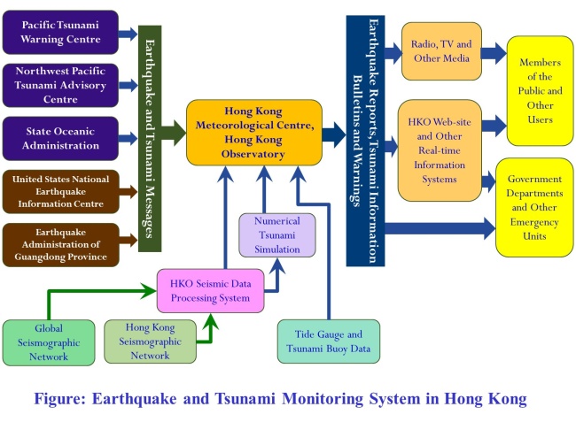
Hong Kong being a coastal city must be prepared against the non-zero probability of a damaging tsunami even though the chance is remote. The Hong Kong Observatory commissioned a broadband seismograph station inside a deep tunnel off Po Shan Road on the Hong Kong Island in 2010 and participated in real-time international exchange of seismic data to enhance the detection of earthquakes in the South China Sea. In order to enhance its capability in tsunami prediction, the Observatory implemented a numerical tsunami model promulgated by the UNESCO Intergovernmental Oceanographic Commission (IOC). After adapting the model for local application, the Observatory successfully simulated the tsunami generated by a magnitude 7.1 earthquake over the sea south of Hengchun, Taiwan on 26 December 2006. The highest tsunami recorded at Tai Miu Wan, Hong Kong was 11 cm peak-to-trough that night which was close to the simulated value of 14 cm. The time of tsunami arrival given in the simulation also agreed with the measurement rather well. Apart from Hong Kong, other countries bordering the South China Sea also enhanced their earthquake and tsunami detection capabilities in the past few years. Asian Disaster Prevention Centre located in Thailand, established four new broadband seismograph stations in Vietnam, the Philippines and Myanmar. Vietnam and the Philippines each has a new tide gauge station built adjacent to the South China Sea for monitoring real-time sea level changes. The State Oceanic Administration has deployed tsunami buoys near the Manila Trench in the South China Sea to measure tsunamis in the sea. It is apparent that the international community spares no effort in ensuring public safety.
Under the present Tsunami Warning System in Hong Kong, the Observatory will issue tsunami warnings to inform the public if a significant tsunami with a height of 0.5 metre or above is expected in Hong Kong. Since the Tsunami Warning System was established in the 1960s, no tsunami warning has been issued in the past five decades. To increase public awareness of the Tsunami Warning System, the Observatory introduced Tsunami Information Bulletins in recent years to report on insignificant tsunami events where the tsunami height is small. The Observatory also joined hands with the Security Bureau and relevant government departments to participate in the Pacific-wide tsunami exercises organised by the Pacific Tsunami Warning and Mitigation System (PTWS) in 2006 and 2008. We are also preparing to take part in another planned exercise in November 2011 in order to enhance our readiness to deal with tsunamis.
Public knowledge is a vital mitigation measure against tsunami. In addition to promoting public education via pamphlets and website, the Observatory also cooperated with the State Oceanic Administration to translate the IOC scientific educational booklet "Tsunami - the Great Waves" into Chinese for publication, with the electronic version posted on the websites of IOC and HKO for reference by members of the public. The Observatory also organised public seminars from time to time to promote knowledge on earthquake and tsunami. Interested readers are welcome to visit the Observatory website for electronic copies of pamphlets and other education materials, as well as news of public seminars.
Reference:
[1] https://en.wikipedia.org/wiki/File: Plates_tect2_en.svg
[1] https://en.wikipedia.org/wiki/File: Plates_tect2_en.svg