Nocturnal Jet
Nocturnal Jet
CHAN Ying-wa
March 2012
Nocturnal jet is a fast-moving air current in the lower atmosphere during nighttime when the skies are clear. As air temperatures near the ground drop after sunset, an inversion layer is formed in the lower atmosphere during the night. Within the inversion layer, air temperature rises as height increases. This tends to enhance atmospheric stability and suppress atmospheric vertical motion. Air then tends to flow horizontally and becomes less inhibited by turbulence and convection which tend to dominate during daytime when the ground surface heats up as a result of insolation. Many literatures have reported on the occurrences of nocturnal jets in Europe, the Great Plains in USA and Africa, etc. In Hong Kong, weather conditions in autumn are often favourable for the formation of nocturnal jets, as illustrated by the example below.
In late October 2010, a dry northeast monsoon brought fine weather to Hong Kong. The Observatory's wind profiler at Cheung Chau captured the development and dissipation of nocturnal jets on 30-31 October (Figure 1). Solar heating during daytime caused air temperatures near the ground to rise above 20oC, triggering turbulent mixing that tend to reduce the wind speeds in the lower atmosphere. The vertical profile of winds on the afternoon of 30 October 2010 (blue line) showed that wind speeds below 1,800 m were less than 10 m/s and the vertical variations of wind speed were generally small. After sunset, a jet with maximum wind speed exceeding 20 m/s appeared at an altitude between 1,600 m and 1,800 m (purple line). After midnight, the jet core descended to an altitude between 800 m and 1,000 m (green line). The formation of the jet also meant an increase in vertical wind shear, i.e. abrupt changes of wind speeds with height. After daybreak the next morning, the jet weakened as wind speeds at the jet core dropped below 15 m/s (pink line). In the afternoon, the vertical profile of wind speeds resumed a pattern similar to the day before (orange line).
The Observatory's Tai Mo Shan wind station at a height of over 950 m above mean sea level also recorded the occurrence of nocturnal jet during the 2-day period (Figure 2). The time series of wind speeds showed that wind speeds started to increase significantly by late afternoon on 30 October. Winds exceeded 12 m/s and the jet was largely maintained up to around 8 a.m. the next morning. Wind speeds then decreased sharply during the day before another rise appearing in the evening.
Nocturnal jet and its associated vertical wind shear can pose a threat to aviation safety. Camping on high grounds during the cool season may be affected by the occurrence of strong winds that can bring down tents or blow away loose items.
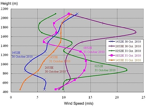
Figure 1: The vertical profiles of wind speeds at 1452H (blue line), 2053H (purple line) on 30 October 2010 and 0252H (green line), 0852H (pink line), 1453H (orange line) on 31 October 2010, as recorded by the Observatorys wind profiler at Cheung Chau.
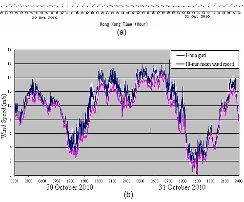
Figure 2: Wind changes recorded at Tai Mo Shan on 30 - 31 October 2010: (a) wind barbs on the hour, with 10-minute mean wind speeds; (b) 1-minute maximum gusts (blue) and 10-minute mean wind speeds (pink).
References:
[1] "An Introduction to Boundary Layer Meteorology", by Roland B. Stull, (1988), Kluwer Academic Publishers.
[2] "Development and mechanism of the nocturnal jet", by Davis, P.A., (2000), Meteorol. Appl., 7: 239-246.
[1] "An Introduction to Boundary Layer Meteorology", by Roland B. Stull, (1988), Kluwer Academic Publishers.
[2] "Development and mechanism of the nocturnal jet", by Davis, P.A., (2000), Meteorol. Appl., 7: 239-246.