In January 2014, many regions over North America, such as eastern Canada and the northeastern part of the United States, were affected by blizzards and extreme cold weather with temperatures falling below -20?C at certain places. It is usually difficult to associate individual extreme cold weather events attribute to global warming. However, some meteorologists have proposed that the continual decline of the Arctic sea ice may have led to a modification of the mid to high-latitude atmospheric circulation, thereby increasing the chance of the occurrence of extreme weather events[1].
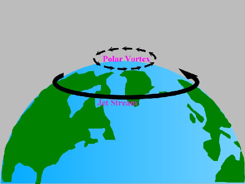
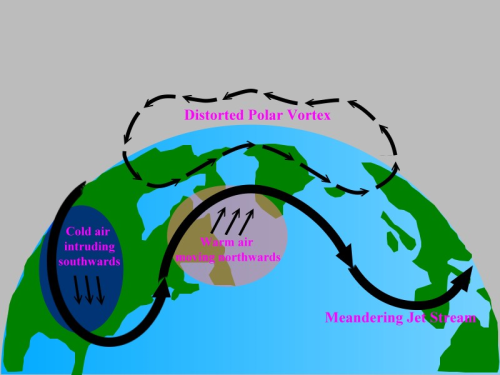
Under normal circumstances, a strong temperature gradient is built up between the Arctic regions and the mid to high-latitude regions during the winter season of the Northern Hemisphere. This temperature gradient leads to the formation of a jet stream high in the atmosphere, flowing from west to east around the globe. The vortex, normally situated around the North Pole, surrounded by the jet stream is often known as the Polar Vortex. If the speed of the jet stream is high, it will follow a more straight-flowing pattern (Figure 1) and the cold air on the surface is more confined to the polar or higher latitude regions and has a lower chance to intrude southwards. But in the recent years, as the rate of warming at the polar region is higher than that in the mid to high-latitude region, mainly due to the enhanced absorption of solar radiation at the polar region caused by the loss of Arctic sea ice, the temperature gradient is weakening. As a result, the jet stream decreases in speed and changes to a more meandering flow pattern (Figure 2) which causes distortion of the Polar Vortex. The situation is similar to a turbulent river flowing towards a flat plain which slows down the river flow and leads to a more winding path of the river. As the jet stream meanders, certain places are influenced by the frequent intrusion of cold air from the north while other locations experience warmer weather due to migration of warm air from the south. On the whole, the geographical distribution of temperatures tends to be more diverse and extreme.

| Figure 1 | During the winter season of the Northern Hemisphere, the Polar Vortex is developed as a result of the strengthening of the jet stream over the mid- to high-latitude regions. |
Although the above postulate requires further verification, it is vital for all of us to aware that the impacts of global warming are imminent, even though perhaps the occurrence of a record breaking cold season may prompt some people to cast doubt on global warming.

| Figure 2 | The jet stream over the Northern Hemisphere decreases in its flow speed and causes the distortion of the Polar Vortex, increasing the frequency of surface cold air spreading to the south and warm air moving to the north respectively. The geographical distribution of temperatures tends to become more diverse and extreme. |
