Tiny vortices embedded in the eye of a tropical cyclone
20 November 2019
Since I became a member of the Hong Kong Observatory's social media team, it has been my everyday job to browse through weather-related information appearing on various online platforms and look for suitable topics for writing social media posts for the Observatory. Here I would like to share with you my memorable experience happened recently. When Typhoon Tapah moved across the East China Sea in September 2019, an aircraft passenger shared a spectacular photo taken during his flight on an online forum. Two clusters of spiral cloud bands could be observed clearly from the photo, one near the plane and the other farther away (Fig. 1).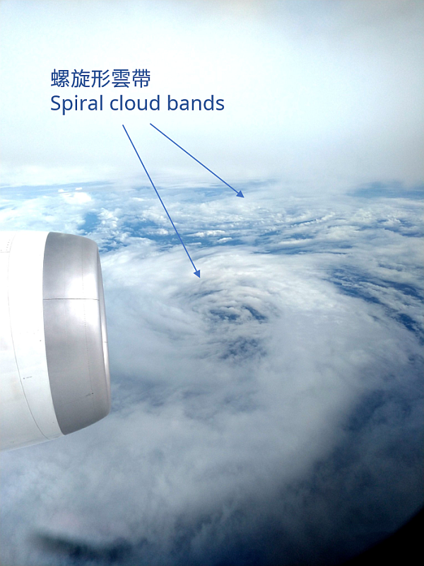
Fig. 1: Spiral cloud bands photographed from an aircraft (Photo: Mr Ken Tong)
To be honest, my colleagues and I were not very convinced about the authenticity of the photo at first sight. This is because, generally speaking, convective clouds from a mature tropical cyclone could develop vertically up to the tropopause (over 16,000 m in the tropics), which is higher than the typical cruising altitude of the civilian aircraft (about 12,000 m). It is almost impossible to have a complete view of a tropical cyclone from a civilian aircraft, thus the spiral cloud bands in Fig. 1 should not be Typhoon Tapah in its entirety.
So what are the spiral cloud bands in the photo? In the spirit of scientific truth-seeking, we contacted the photographer, Mr Tong, via social media to learn more details about the photo, including the exact date and time when the photo was taken, the flight number of the aircraft, etc. We would like to take this opportunity to express our sincere gratitude to Mr Tong for not only providing the relevant information promptly, but also sending us the original file of the photo and generously allowing the Observatory to use it for public education purpose.
Mr Tong was on his way from Japan to Taipei when the photo was taken at around 2:25 pm (HKT) on 21 September. With the flight number provided by Mr Tong, we were able to find out the approximate location of the aircraft at that time using flight-tracking websites, and compare the location with satellite imagery (Fig. 2). From the imagery, we can see that the circulation near the centre of Tapah was not very compact. There were several tiny vortices near the storm centre, and the vortices were revolving around the centre of the typhoon (Fig. 3). Two of these vortices were believed to be those spiral cloud bands shown on the photo. Since the cloud bands were made up of lower-level clouds below the cruising altitude of the plane, such magnificent scene could be viewed on the aircraft.
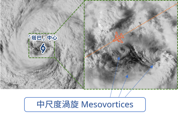
Fig. 2. Satellite imagery of Typhoon Tapah on 21 September 2019 (2:35 pm HKT). Several mesovortices could be observed near the centre of Tapah. Orange aircraft symbol on the right indicates the approximate location of the aircraft which Mr Tong (photographer of fig. 1) was on board at that time, and the orange dotted line denotes its approximate flight path. (Courtesies: Himawari-8 satellite of Japan Meteorological Agency for the satellite imagery; Flightradar24.com for the aircraft flight information)
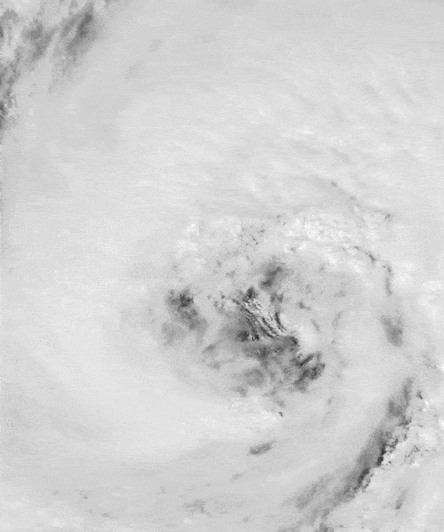
Fig. 3. Satellite imagery animation of Typhoon Tapah on 21 September 2019 (1:00 pm to 3:30 pm HKT). (Courtesy: Himawari-8 satellite of Japan Meteorological Agency)
These low-level vortices near typhoon centres, academically known as "mesovortices", are indeed not rare. Hagibis, which caused severe damages to Honshu, Japan last month (October 2019), also exhibited this type of mesovortices near its eye when it tracked across the western North Pacific (Fig. 4). In 2003, even 6 mesovortices were once sighted near the eye of Hurricane Isabel over the Atlantic Ocean (Fig. 5)! According to scientific literature, mesovortices can form near the eyewall and move to the storm centre, thereby transporting angular momentum from the eyewall to the eye. Some scientists believe that this plays an essential role in the intensification of tropical cyclones. While detailed formation mechanisms of these mesovortices are rather complex, one of the possibilities is that when the wind speed at the typhoon eyewall is substantially higher than that at the eye centre, the wind speed difference will make the air become unstable. If such instability is accompanied by other suitable conditions, tiny spinning vortices may then form near the vicinity of the inner side of the eyewall. [References 1 to 4]
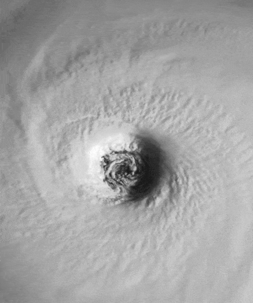
Fig. 4. Satellite imagery animation of Super Typhoon Hagibis on 10 October 2019 (7:00 am to 1:30 pm HKT). (Courtesy: Himawari-8 satellite of Japan Meteorological Agency)
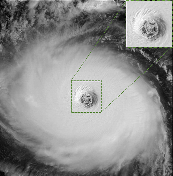
Fig. 5. Satellite imagery of Hurricane Isabel on 12 September 2003 (13:15 UTC). 6 mesovortices could be observed in the eye (1 at the centre and 5 surrounding it). (Courtesy: CIMSS / NOAA GOES-12 satellite)
Although quite a lot of efforts in collecting information and fact-checking were made before the photo could be shared on the Observatory's Facebook page, it has been very rewarding to see that it could raise public awareness on the weather phenomenon. Popularity of smartphones has made capturing rare weather phenomena a lot easier. If you have the chance to take a photo of spectacular weather phenomena and would like to share it with others, or if you would like to view the great work by the others, you are most welcome to join the Observatory's Facebook group "Community Weather Observing Scheme (CWOS)". The photo or video you share may even be featured on the Observatory's Facebook page or Instagram account!
TSOI Tze-shun
References:
[1] Kossin, J. P., B. D. McNoldy, and W. H. Schubert, 2002: Vortical swirls in hurricane eye clouds. Mon. Wea. Rev., 130, 3144-3149.
[2] Montgomery, M. T., V. A. Vladimirov, and P. V. Denissenko, 2002: An experimental study on hurricane mesovortices. J. Fluid Mech., 471, 1-32.
[3] Kossin, J. P. and W. H. Schubert, 2001 Mesovortices, polygonal flow patterns, and rapid pressure
falls in hurricane-like vortices. J. Atmos. Sci. 58, 2196-2209.
[4] Kossin, J. P. and W. H. Schubert, 2004: Mesovortices in Hurricane Isabel. Bull. Amer. Meteor. Soc., 85, 151-153.