Let's talk about rainstorm warning (Part 2): Q&A
10 April 2018
Last time, we discussed the purpose of and the factors being considered in establishing the rainstorm warning system. We will look at some commonly asked questions this time.
Q: Why not implement district-level rainstorm warning?
The development and movement of a rainstorm are very quick at times and can change greatly in a short time. If district-level rainstorm warning were implemented, the warning levels for different districts at different time would likely be rather different, causing confusion to those who commute cross different districts. This will also pose great challenges to the media in conveying the rapidly changing warning messages to the public.
Taking the heavy rain episode on the morning of 25 May 2013 as an example (Figure 1), the hourly rainfall over Lantau Island, Lamma Island and Wong Chuk Hang once exceeded 40 millimetres (yellow region in Figure 1). The rain band subsequently moved northwards quickly. The rain over those districts previously under downpour subsided swiftly, while that over Tsing Yi, Tsuen Wan and Ma On Shan became heavy. If district-level rainstorm warning were implemented, the warning levels for the districts mentioned above would change within a short time, and the public would find it difficult to cope with: should they continue to go to work or to school? Should their decision be made based on the warning level of the departing district or that of destination? Should the district enroute to work or to school be also taken into consideration? The situation will then become highly complicated.
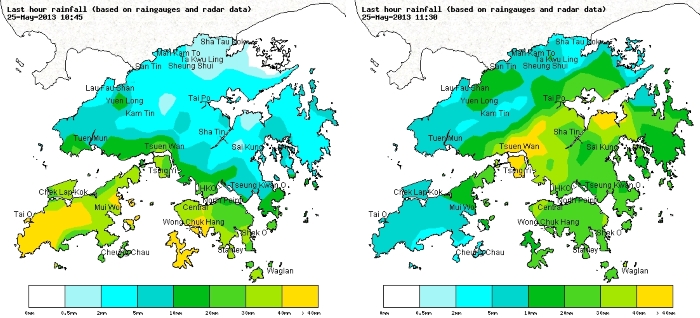
Figure 1 Rainfall distribution at 10:45 a.m. and 11:30 a.m. on 25 May 2013.
Q: Why were there occasions when the rain was not heavy or there was even no rain at my location while the Observatory had issued the rainstorm warning?
There are some degrees of randomness in where heavy rain falls and how its intensity changes. Taking the "Red Rainstorm" on the morning of 10 May 2016 as an example (Figure 2), most parts of the New Territories were affected by the torrential rain, yet rain was not heavy over Lantau Island. There was even no rain in many places of Hong Kong Island and Kowloon. To get hold of the changes in rainstorm, one can refer to the Observatory's radar imageries (Figure 3 - red, orange and yellow mean heavier rainfall) for the location, intensity and direction of movement of the rain area.
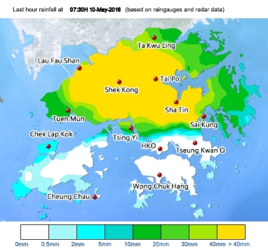
Figure 2 Distribution of past-hour rainfall at 7:30 a.m. on 10 May 2016.
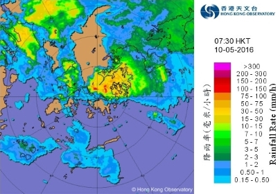
Figure 3 Radar imagery at 7:30 a.m. on 10 May 2016.
Q: Why can't the Observatory predict the arrival of rainstorm a couple of hours in advance so as to avoid issuing the Red or Black Rainstorm Warning during "embarrassing time" (e.g. the time when travelling to work or to school) and minimize inconvenience?
Rainstorm can change vastly in a matter of an hour or even less. Issuing the Red or Black Rainstorm Warning accurately or providing early alert a couple of hours in advance is still a challenge at the current level of science and technology. If we often issue the rainstorm warning too early such that the rain band suddenly weakens or moves elsewhere, the adverse effect of "crying wolf" will come sooner or later. Taking the situation on the night of 6 May 2016 as an example (Figure 4), there was a very broad area of intense rain approaching Hong Kong from the northwest, but it weakened abruptly right before reaching Hong Kong and then skirted the north of the territory. This exemplifies the difficulty of location-based and quantitative forecast of rain. It is difficult to issue rainstorm warning a couple of hours in advance. If a warning has to be issued at the so-called "embarrassing time", while it will inevitably cause inconvenience to people going to work or to school, we hope the public can understand that such decision is made for the sake of safety. We advise every sector in the society to formulate contingency arrangements for rainstorm prior to the rain season so that they can be readily deployed when necessary.
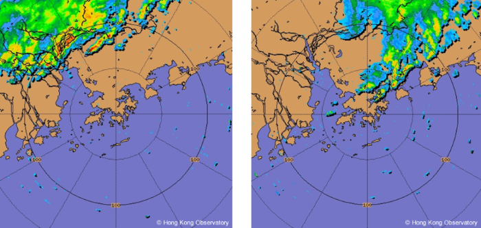
Figure 4 Radar imageries at 7:30 p.m. (left) and 9:30 p.m. (right) on 6 May 2016.
L.S. LeeM.C. Chow
Q: Why not implement district-level rainstorm warning?
The development and movement of a rainstorm are very quick at times and can change greatly in a short time. If district-level rainstorm warning were implemented, the warning levels for different districts at different time would likely be rather different, causing confusion to those who commute cross different districts. This will also pose great challenges to the media in conveying the rapidly changing warning messages to the public.
Taking the heavy rain episode on the morning of 25 May 2013 as an example (Figure 1), the hourly rainfall over Lantau Island, Lamma Island and Wong Chuk Hang once exceeded 40 millimetres (yellow region in Figure 1). The rain band subsequently moved northwards quickly. The rain over those districts previously under downpour subsided swiftly, while that over Tsing Yi, Tsuen Wan and Ma On Shan became heavy. If district-level rainstorm warning were implemented, the warning levels for the districts mentioned above would change within a short time, and the public would find it difficult to cope with: should they continue to go to work or to school? Should their decision be made based on the warning level of the departing district or that of destination? Should the district enroute to work or to school be also taken into consideration? The situation will then become highly complicated.
Figure 1 Rainfall distribution at 10:45 a.m. and 11:30 a.m. on 25 May 2013.
Q: Why were there occasions when the rain was not heavy or there was even no rain at my location while the Observatory had issued the rainstorm warning?
There are some degrees of randomness in where heavy rain falls and how its intensity changes. Taking the "Red Rainstorm" on the morning of 10 May 2016 as an example (Figure 2), most parts of the New Territories were affected by the torrential rain, yet rain was not heavy over Lantau Island. There was even no rain in many places of Hong Kong Island and Kowloon. To get hold of the changes in rainstorm, one can refer to the Observatory's radar imageries (Figure 3 - red, orange and yellow mean heavier rainfall) for the location, intensity and direction of movement of the rain area.
Figure 2 Distribution of past-hour rainfall at 7:30 a.m. on 10 May 2016.
Figure 3 Radar imagery at 7:30 a.m. on 10 May 2016.
Q: Why can't the Observatory predict the arrival of rainstorm a couple of hours in advance so as to avoid issuing the Red or Black Rainstorm Warning during "embarrassing time" (e.g. the time when travelling to work or to school) and minimize inconvenience?
Rainstorm can change vastly in a matter of an hour or even less. Issuing the Red or Black Rainstorm Warning accurately or providing early alert a couple of hours in advance is still a challenge at the current level of science and technology. If we often issue the rainstorm warning too early such that the rain band suddenly weakens or moves elsewhere, the adverse effect of "crying wolf" will come sooner or later. Taking the situation on the night of 6 May 2016 as an example (Figure 4), there was a very broad area of intense rain approaching Hong Kong from the northwest, but it weakened abruptly right before reaching Hong Kong and then skirted the north of the territory. This exemplifies the difficulty of location-based and quantitative forecast of rain. It is difficult to issue rainstorm warning a couple of hours in advance. If a warning has to be issued at the so-called "embarrassing time", while it will inevitably cause inconvenience to people going to work or to school, we hope the public can understand that such decision is made for the sake of safety. We advise every sector in the society to formulate contingency arrangements for rainstorm prior to the rain season so that they can be readily deployed when necessary.
Figure 4 Radar imageries at 7:30 p.m. (left) and 9:30 p.m. (right) on 6 May 2016.
L.S. LeeM.C. Chow