Story of a Bolt
6 September 2016
What is meant by "the height" of sea level in the Observatory's reports of astronomical high tides or the highest sea level during the passage of a typhoon?
The following example is extracted from a tropical cyclone bulletin issued by the Observatory during the passage of Typhoon Kalmaegi on 16 September 2014: "A high water level of 3 metres (m) above Chart Datum is expected at Quarry Bay between 1:00 a.m. and 4:00 a.m. The high water level may cause flooding in low-lying areas."
Chart Datum (CD) is not only the reference often quoted for describing sea level, but also the reference quoted for describing sea depth[1]. For such purposes, it is therefore desirable that the reference is set at a level low enough to remain under the sea water most of the time, and as such is usually defined in terms of the lowest astronomical tides. As the tide levels vary from place to place, the levels of Chart Datum for different places are not the same. In Hong Kong, the definition of Chart Datum all started with a bolt (Figure 1).
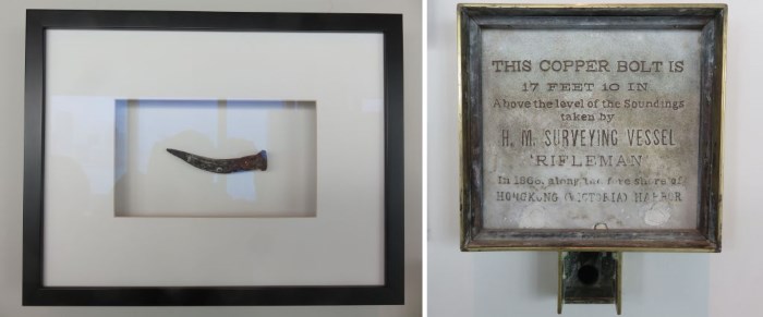
Figure 1The 'Rifleman's Bolt' (left) and details of the soundings taken by H.M. Surveying Vessel Rifleman in 1866 (right) as displayed at the Hong Kong Maritime Museum, on loan from the Lands Department (courtesy of the Lands Department and the Hong Kong Maritime Museum).
Back in 1866, the surveyors of the H.M. Surveying Vessel Rifleman were mapping the northern shore of Hong Kong Island and fixed a bolt (then known as the 'Rifleman's Bolt') on a block of granite cornerstone at the Royal Naval Dockyard (now near the MTR Admiralty Station, Wanchai) as a benchmark. The level of the bolt was found to be 17 feet 10 inches (5.435 m) above a datum measured at the time. This datum was subsequently adopted as the Principal Datum (PD), serving as a reference for all heights and levels measured on land[1]. The height above Principal Datum is obtained by adding 5.435 m to the height as measured against the Rifleman's Bolt. Making reference to the Rifleman's Bolt, more than 1,700 (up to January 2016) benchmarks had been established in the territory since then for height surveying purpose [2].
Dr William Doberck, the first Director of the Hong Kong Observatory, conducted tidal measurements in Victoria Harbour near Tsim Sha Tsui using a tide gauge in 1887-1889 and derived the mean sea level, the highest and lowest tide[3]. The tidal readings were subsequently analysed by the then Nautical Almanac Office of UK and the analysis results formed the basis for tide predictions for Hong Kong published in the tide tables by the Admiralty, UK since 1893[4]. In the early 1910s, a datum of 19 feet 2 inches (5.842 m) below the Rifleman's Bolt, corresponding to an exceptionally low spring tide (Figure 2) was adopted for the daily tide predictions in the tide tables. In 1917, the zero of the tidal predictions for Hong Kong in the tide table was changed to 18.31 feet (5.581 m) below the Rifleman's Bolt or 0.48 foot (0.146 m) below the Principal Datum (Figure 3), reference for which had been made to the lowest tide level during Spring Water in India(1). Since then, it was also adopted as the datum of the Admiralty charts (called as Chart Datum later) of Hong Kong for all offshore bathymetrical surveys[6,7]. Figure 4 illustrates the relationships between the Rifleman's Bolt and the mean sea level, tide level, sea depth and various datums.
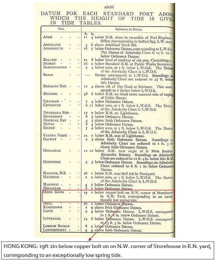
Figure 2Description of datum for tide for Hong Kong in "Tide Tables for Standard Ports in the United Kingdom and Other Parts of The World for the Year 1914" published by the Admiralty, UK (courtesy of the UK Hydrographic Office (www.ukho.gov.uk))
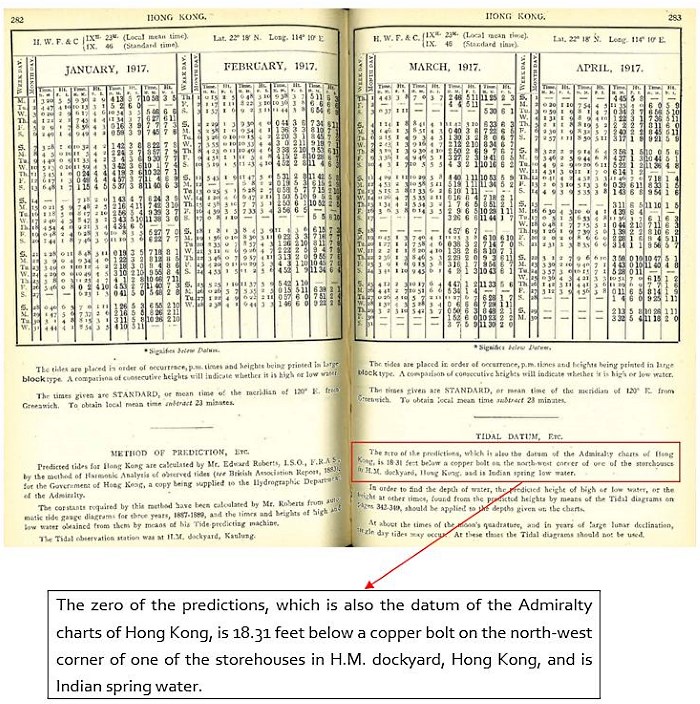
Figure 3Description of datum for tide for Hong Kong in "Tide Tables for Standard Ports in the United Kingdom and Other Parts of The World for the Year 1917" published by the Admiralty, UK (courtesy of the UK Hydrographic Office (www.ukho.gov.uk))
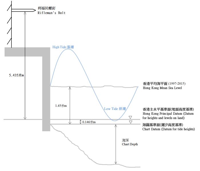
Figure 4Schematic showing the relationships between the Rifleman's Bolt and the mean sea level, tide level, chart depth and various datums (not to scale), with the variation of tides shown in blue.
The Rifleman's Bolt was temporarily re-located in 1959, and then moved to the east wall of Blake Block in the HMS Tamar buildings in 1962 after demolition of the original site. With the British naval base moving to the Stonecutters Island in April 1997, the Rifleman's Bolt was also removed and taken away. It was later returned to the Lands Department of Hong Kong for retention[8]. With the completion of its historical mission, the Rifleman's Bolt is now displayed as a piece of monument at the Hong Kong Maritime Museum.
H.Y. Mok and W.H. Lui
Note:
(1) A tidal low water datum, designed for regions of mixed tides, originally developed for parts of the Indian Ocean[5].
References:
[1] Website of Lands Department on Explanation of Levels in Hong Kong (https://www.landsd.gov.hk/mapping/en/publications/map.htm)
[2] Information on benchmarks in Hong Kong: https://www.geodetic.gov.hk/smo/gsi/programs/en/GSS/GSI/keymaps.htm
[3] Observations made at the Hong Kong Observatory in the year 1889, W. Doberck, Director, 1891
[4] Report of the Director of the Observatory for 1891 and 1892
[5] Glossary of Meteorology (https://glossary.ametsoc.org/wiki/Main_Page)
[6] High-level coastal deposits in Hong Kong, GEO Report No. 243, J.C.F. Wong and R. Shaw, Geotechnical Engineering and Development Department (https://www.cedd.gov.hk/eng/publications/geo_reports/doc/er243/er243links.pdf)
[7] Explanatory Notes on Geodatic Datums in Hong Kong, Survey & Mapping Office, Lands Department, page A5 (https://www.geodetic.gov.hk/data/pdf/explanatorynotes.pdf)
[8] Hong Kong Maritime Museum Exhibit on 'Rifleman's Bolt and brass plaque for commemorating the relocation of the Bolt in 1962'
The following example is extracted from a tropical cyclone bulletin issued by the Observatory during the passage of Typhoon Kalmaegi on 16 September 2014: "A high water level of 3 metres (m) above Chart Datum is expected at Quarry Bay between 1:00 a.m. and 4:00 a.m. The high water level may cause flooding in low-lying areas."
Chart Datum (CD) is not only the reference often quoted for describing sea level, but also the reference quoted for describing sea depth[1]. For such purposes, it is therefore desirable that the reference is set at a level low enough to remain under the sea water most of the time, and as such is usually defined in terms of the lowest astronomical tides. As the tide levels vary from place to place, the levels of Chart Datum for different places are not the same. In Hong Kong, the definition of Chart Datum all started with a bolt (Figure 1).
Figure 1The 'Rifleman's Bolt' (left) and details of the soundings taken by H.M. Surveying Vessel Rifleman in 1866 (right) as displayed at the Hong Kong Maritime Museum, on loan from the Lands Department (courtesy of the Lands Department and the Hong Kong Maritime Museum).
Back in 1866, the surveyors of the H.M. Surveying Vessel Rifleman were mapping the northern shore of Hong Kong Island and fixed a bolt (then known as the 'Rifleman's Bolt') on a block of granite cornerstone at the Royal Naval Dockyard (now near the MTR Admiralty Station, Wanchai) as a benchmark. The level of the bolt was found to be 17 feet 10 inches (5.435 m) above a datum measured at the time. This datum was subsequently adopted as the Principal Datum (PD), serving as a reference for all heights and levels measured on land[1]. The height above Principal Datum is obtained by adding 5.435 m to the height as measured against the Rifleman's Bolt. Making reference to the Rifleman's Bolt, more than 1,700 (up to January 2016) benchmarks had been established in the territory since then for height surveying purpose [2].
Dr William Doberck, the first Director of the Hong Kong Observatory, conducted tidal measurements in Victoria Harbour near Tsim Sha Tsui using a tide gauge in 1887-1889 and derived the mean sea level, the highest and lowest tide[3]. The tidal readings were subsequently analysed by the then Nautical Almanac Office of UK and the analysis results formed the basis for tide predictions for Hong Kong published in the tide tables by the Admiralty, UK since 1893[4]. In the early 1910s, a datum of 19 feet 2 inches (5.842 m) below the Rifleman's Bolt, corresponding to an exceptionally low spring tide (Figure 2) was adopted for the daily tide predictions in the tide tables. In 1917, the zero of the tidal predictions for Hong Kong in the tide table was changed to 18.31 feet (5.581 m) below the Rifleman's Bolt or 0.48 foot (0.146 m) below the Principal Datum (Figure 3), reference for which had been made to the lowest tide level during Spring Water in India(1). Since then, it was also adopted as the datum of the Admiralty charts (called as Chart Datum later) of Hong Kong for all offshore bathymetrical surveys[6,7]. Figure 4 illustrates the relationships between the Rifleman's Bolt and the mean sea level, tide level, sea depth and various datums.
Figure 2Description of datum for tide for Hong Kong in "Tide Tables for Standard Ports in the United Kingdom and Other Parts of The World for the Year 1914" published by the Admiralty, UK (courtesy of the UK Hydrographic Office (www.ukho.gov.uk))
Figure 3Description of datum for tide for Hong Kong in "Tide Tables for Standard Ports in the United Kingdom and Other Parts of The World for the Year 1917" published by the Admiralty, UK (courtesy of the UK Hydrographic Office (www.ukho.gov.uk))
Figure 4Schematic showing the relationships between the Rifleman's Bolt and the mean sea level, tide level, chart depth and various datums (not to scale), with the variation of tides shown in blue.
The Rifleman's Bolt was temporarily re-located in 1959, and then moved to the east wall of Blake Block in the HMS Tamar buildings in 1962 after demolition of the original site. With the British naval base moving to the Stonecutters Island in April 1997, the Rifleman's Bolt was also removed and taken away. It was later returned to the Lands Department of Hong Kong for retention[8]. With the completion of its historical mission, the Rifleman's Bolt is now displayed as a piece of monument at the Hong Kong Maritime Museum.
H.Y. Mok and W.H. Lui
Note:
(1) A tidal low water datum, designed for regions of mixed tides, originally developed for parts of the Indian Ocean[5].
References:
[1] Website of Lands Department on Explanation of Levels in Hong Kong (https://www.landsd.gov.hk/mapping/en/publications/map.htm)
[2] Information on benchmarks in Hong Kong: https://www.geodetic.gov.hk/smo/gsi/programs/en/GSS/GSI/keymaps.htm
[3] Observations made at the Hong Kong Observatory in the year 1889, W. Doberck, Director, 1891
[4] Report of the Director of the Observatory for 1891 and 1892
[5] Glossary of Meteorology (https://glossary.ametsoc.org/wiki/Main_Page)
[6] High-level coastal deposits in Hong Kong, GEO Report No. 243, J.C.F. Wong and R. Shaw, Geotechnical Engineering and Development Department (https://www.cedd.gov.hk/eng/publications/geo_reports/doc/er243/er243links.pdf)
[7] Explanatory Notes on Geodatic Datums in Hong Kong, Survey & Mapping Office, Lands Department, page A5 (https://www.geodetic.gov.hk/data/pdf/explanatorynotes.pdf)
[8] Hong Kong Maritime Museum Exhibit on 'Rifleman's Bolt and brass plaque for commemorating the relocation of the Bolt in 1962'