U-turn of Lionrock
1 September 2016
If you ever noticed the weather reports last week, you might find the track of tropical cyclone Lionrock very peculiar. It first moved southwest over the seas south of Japan, but made an acute turn to the northeast later on (Figure 1). Why was there such a dramatic change in its track within just a week?
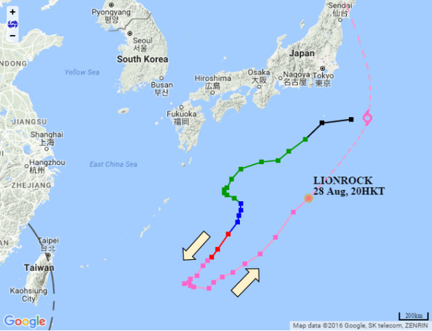
Figure 1Lionrock generally moved southwest at first, but turned to the northeast afterwards.
At first, there were actually two tropical cyclones, Mindulle and Kompasu, nearby Lionrock (Figure 2). Under the interaction between the tropical cyclones (please refer to the blog : Interactions between Tropical Cyclones), Lionrock tracked southwest towards the seas east of Ryukyu Islands.
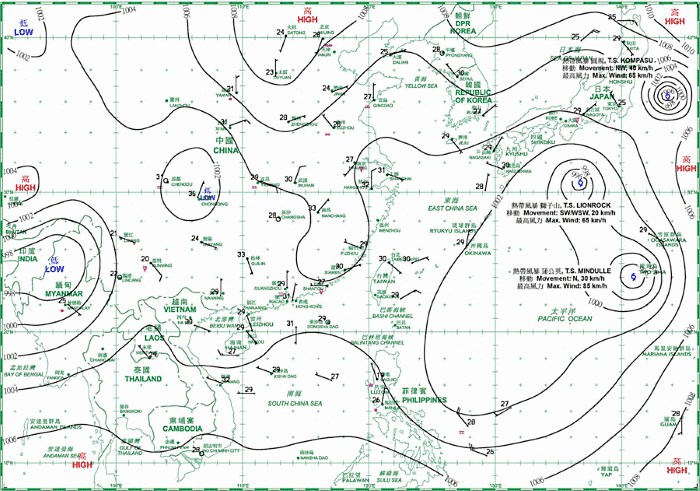
Figure 2The weather chart at 8 p.m. on 20 August 2016.
When Lionrock moved far away from Mindulle and Kompasu, the main factor affecting its track was the large-scale steering flow. As an analogy, a tropical cyclone is like a ball that drifts with the flow of river. The steering flow in the atmosphere is likened to a river flow, leading the way for a tropical cyclone. With reference to the upper air analysis on 25 August (Figure 3), Lionrock was located between two ridges of high pressure. As air flows in a clockwise direction around a ridge of high pressure in the Northern Hemisphere, the ridge of high pressure aloft inland China steered Lionrock to the southwest while that over western North Pacific steered it to the northeast. The two opposite steering flows counteracted each other, resulting in a weak steering flow between the two ridges. This weather situation persisted for around two days and Lionrock lingered over the seas east of Ryukyu Islands under the weak steering flow.
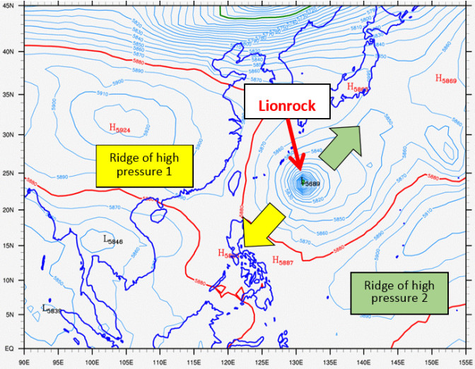
Figure 3Geopotential heights at 500 hectopascals level at 8 a.m. on 25 August 2016. The yellow arrow indicates the direction of steering on Lionrock by the ridge of high pressure aloft China (Ridge of high pressure 1). The green arrow indicates the direction of steering by the ridge aloft western North Pacific (Ridge of high pressure 2).
On 27 and 28 August, the ridge of high pressure aloft inland China weakened and retreated westwards (Figure 4), leading to a reduced steering on Lionrock. Under the dominance of the steering flow by the ridge of high pressure aloft western North Pacific, Lionrock made a U-turn and accelerated to the northeast.
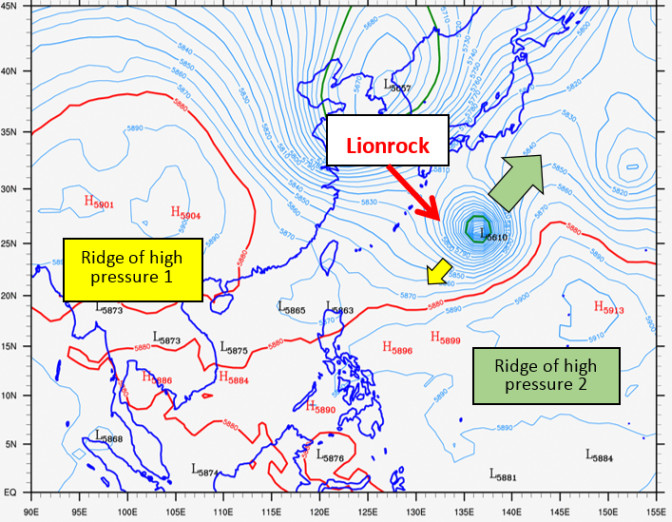
Figure 4Geopotential heights at 500 hectopascals level at 8 a.m. on 28 August 2016. The steering flow in the northeast direction was stronger than that directed to the southwest.
Tropical cyclone is so changeable and Lionrock is a typical example of how special the track can be. In fact, it is the complicated nature of tropical cyclone that drives meteorologists around the world to pursue more studies. The Observatory will also continue to conduct research and accumulate more experience in order to improve the accuracy of tropical cyclone forecast.
Stephen P.W. LauL.S. Lee
Figure 1Lionrock generally moved southwest at first, but turned to the northeast afterwards.
At first, there were actually two tropical cyclones, Mindulle and Kompasu, nearby Lionrock (Figure 2). Under the interaction between the tropical cyclones (please refer to the blog : Interactions between Tropical Cyclones), Lionrock tracked southwest towards the seas east of Ryukyu Islands.
Figure 2The weather chart at 8 p.m. on 20 August 2016.
When Lionrock moved far away from Mindulle and Kompasu, the main factor affecting its track was the large-scale steering flow. As an analogy, a tropical cyclone is like a ball that drifts with the flow of river. The steering flow in the atmosphere is likened to a river flow, leading the way for a tropical cyclone. With reference to the upper air analysis on 25 August (Figure 3), Lionrock was located between two ridges of high pressure. As air flows in a clockwise direction around a ridge of high pressure in the Northern Hemisphere, the ridge of high pressure aloft inland China steered Lionrock to the southwest while that over western North Pacific steered it to the northeast. The two opposite steering flows counteracted each other, resulting in a weak steering flow between the two ridges. This weather situation persisted for around two days and Lionrock lingered over the seas east of Ryukyu Islands under the weak steering flow.
Figure 3Geopotential heights at 500 hectopascals level at 8 a.m. on 25 August 2016. The yellow arrow indicates the direction of steering on Lionrock by the ridge of high pressure aloft China (Ridge of high pressure 1). The green arrow indicates the direction of steering by the ridge aloft western North Pacific (Ridge of high pressure 2).
On 27 and 28 August, the ridge of high pressure aloft inland China weakened and retreated westwards (Figure 4), leading to a reduced steering on Lionrock. Under the dominance of the steering flow by the ridge of high pressure aloft western North Pacific, Lionrock made a U-turn and accelerated to the northeast.
Figure 4Geopotential heights at 500 hectopascals level at 8 a.m. on 28 August 2016. The steering flow in the northeast direction was stronger than that directed to the southwest.
Tropical cyclone is so changeable and Lionrock is a typical example of how special the track can be. In fact, it is the complicated nature of tropical cyclone that drives meteorologists around the world to pursue more studies. The Observatory will also continue to conduct research and accumulate more experience in order to improve the accuracy of tropical cyclone forecast.
Stephen P.W. LauL.S. Lee