Forecasting Nepartak
14 July 2016
While Super Typhoon Nepartak (Figure 1) brought havoc to Taiwan last week, it was fortunate that Hong Kong remained safe from its direct impact. Although no Tropical Cyclone Signal No. 1 was necessary, our forecasters had been keeping a vigilant eye on the evolution of Nepartak.
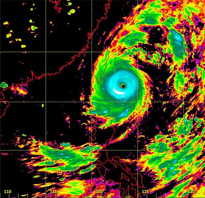
Figure 1Satellite imagery at 1 p.m. on 7 July, showing the distinct eye of Nepartak (Source: Japan Meteorological Agency)
As early as 4 July, the Hong Kong Observatory (HKO) began to issue the forecast track of Nepartak and predicted that it would land in the middle part of Taiwan on 8 July. At that time, other meteorological centres and some computer forecasts (including the European Centre (EC) and the National Weather Service (NWS) of USA) forecast that Nepartak would hit the northern part of Taiwan or even just skirt across the offshore waters. Thereafter, the Observatory revised the forecast track in the morning of 6 July, predicting that Nepartak would land over the southern part of Taiwan. This turned out matching quite closely the actual situation (Figure 2).
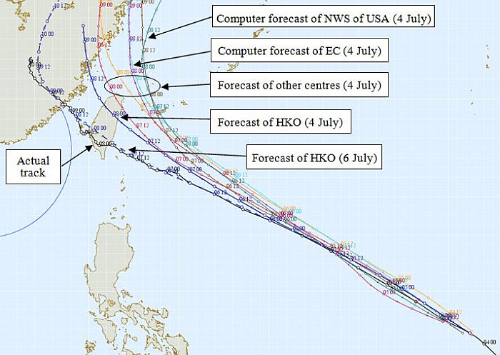
Figure 2Forecast tracks of Nepartak by different meteorological centres
Why did the forecasts of various meteorological centres and computer forecasts differ?
The relatively westerly track forecast by the Observatory was mainly based on the consideration that the subtropical ridge of high pressure over the western Pacific would extend westwards from 4 July to 6 July, and thereafter should remain over there for some time. The flow at its periphery would steer Nepartak to keep its west-northwest track. As such, forecasters chose a relatively westerly track among the computer forecasts. As it turned out, even though the main body of the subtropical ridge weakened on 8 July (i.e. the day when Nepartak landed over Taiwan), a weak ridge still persisted over Taiwan and caused Nepartak to maintain its west-northwest movement (Figure 3).
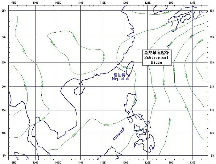
Figure 3Background field of geopotential heights at 500 hectopascals level (after removing the circulation of Nepartak), depicting the extension of subtropical ridge over Taiwan
It was likely that the eastward bias of the forecast tracks of the other centres was due to the eastward-biased tracks of different computer forecasts (Figure 2). As it turned out, forecast tracks of computers (e.g. European Centre) gradually shifted westward day by day from 4 July to 7 July. Only until 7 July did the computer forecast track become steady and resemble the actual conditions (Figure 4).
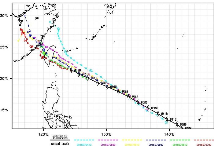
Figure 4Forecast tracks of Nepartak from the European Centre from 4 July to 7 July
Some weather enthusiasts may recall a number of occasions where computer forecasts displayed such systematic bias. Instead of relying too much on computer forecasts, we should take into account all available data and forecast products, and integrate them with our forecasting experience plus analysis of historical cases. Nonetheless, many complicated weather phenomena still remain unsolved by scientists. Forecasters still need to endeavour to deal with each and every challenge of such "unpredictable weather".
L.S. Lee & C.M. Shun
Figure 1Satellite imagery at 1 p.m. on 7 July, showing the distinct eye of Nepartak (Source: Japan Meteorological Agency)
As early as 4 July, the Hong Kong Observatory (HKO) began to issue the forecast track of Nepartak and predicted that it would land in the middle part of Taiwan on 8 July. At that time, other meteorological centres and some computer forecasts (including the European Centre (EC) and the National Weather Service (NWS) of USA) forecast that Nepartak would hit the northern part of Taiwan or even just skirt across the offshore waters. Thereafter, the Observatory revised the forecast track in the morning of 6 July, predicting that Nepartak would land over the southern part of Taiwan. This turned out matching quite closely the actual situation (Figure 2).
Figure 2Forecast tracks of Nepartak by different meteorological centres
Why did the forecasts of various meteorological centres and computer forecasts differ?
The relatively westerly track forecast by the Observatory was mainly based on the consideration that the subtropical ridge of high pressure over the western Pacific would extend westwards from 4 July to 6 July, and thereafter should remain over there for some time. The flow at its periphery would steer Nepartak to keep its west-northwest track. As such, forecasters chose a relatively westerly track among the computer forecasts. As it turned out, even though the main body of the subtropical ridge weakened on 8 July (i.e. the day when Nepartak landed over Taiwan), a weak ridge still persisted over Taiwan and caused Nepartak to maintain its west-northwest movement (Figure 3).
Figure 3Background field of geopotential heights at 500 hectopascals level (after removing the circulation of Nepartak), depicting the extension of subtropical ridge over Taiwan
It was likely that the eastward bias of the forecast tracks of the other centres was due to the eastward-biased tracks of different computer forecasts (Figure 2). As it turned out, forecast tracks of computers (e.g. European Centre) gradually shifted westward day by day from 4 July to 7 July. Only until 7 July did the computer forecast track become steady and resemble the actual conditions (Figure 4).
Figure 4Forecast tracks of Nepartak from the European Centre from 4 July to 7 July
Some weather enthusiasts may recall a number of occasions where computer forecasts displayed such systematic bias. Instead of relying too much on computer forecasts, we should take into account all available data and forecast products, and integrate them with our forecasting experience plus analysis of historical cases. Nonetheless, many complicated weather phenomena still remain unsolved by scientists. Forecasters still need to endeavour to deal with each and every challenge of such "unpredictable weather".
L.S. Lee & C.M. Shun