LIDAR Alerting of Sporadic Windshear
|
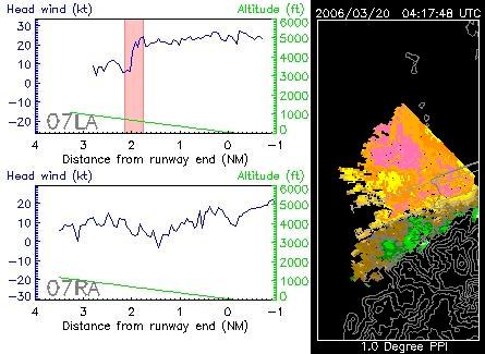
A strong easterly airstream prevailed over the south China coast on 20 March. Due to disruption by terrain on Lantau Island, airflow disturbances occurred over the Hong Kong International Airport (HKIA), causing windshear to the aircraft. There were altogether six pilot reports of windshear encounter on approach to HKIA from the west on that day, including five flights over 07LA runway corridor (landing north runway from the west) and one flight over 07RA corridor (landing south runway from the west). Among these flights, the aircraft using 07RA corridor reported windshear of 10-knot headwind loss followed by 20-knot headwind gain at 12:20 p.m., and conducted missed approach. The headwind profile measured by the LIDAR (figure) indicated that, on the minute before the event, though the wind was quite fluctuating over 07RA, there was no significant windshear reaching 15 knots. However, after a minute when the aircraft over 07RA encountered windshear, the headwind profile changed considerably. There was headwind loss of 15 knots at around 3 nautical miles away from the western end of the south runway. Headwind was basically decreasing afterwards, but rose significantly by about 30 knots at 1 nautical mile west of the runway. The LIDAR Windshear Alerting System (LIWAS) developed by the Observatory successfully captured these abrupt changes of the wind, which were consistent with the pilot report, and issued timely alerts to the aircraft. The horizontal scans of the LIDAR (right hand side of the figure) are useful for further understanding of this windshear event. Before the occurrence of windshear, east to southeasterly winds prevailed over the airport area (warm colour in the figure, indicating that the wind was away from the LIDAR). However, there was an area of southerly wind to the southwest of the south runway (coloured in green in the figure, indicating that the wind blew towards the LIDAR), as a result of disruption by the terrain. At that time, it was mainly confined to the south of 07RA runway corridor. After a few minutes, it was found to extend slightly northwards to affect 07RA corridor, causing significant windshear. Terrain-induced windshear is elusive because of its transient and sporadic nature. But it can't escape the scrutiny of the Observatory's LIWAS. |
Headwind profiles measured by the LIDAR along 07LA and 07RA runway corridors at (a) 12:19 p.m. and (b) 12:20 p.m., 20 March 2006. The red rectangular areas indicate the significant windshear detected by LIWAS. Velocity imageries closer to these moments as obtained by the horizontal scans of the LIDAR are shown on the right. |