Hide and Seek with Fog
|
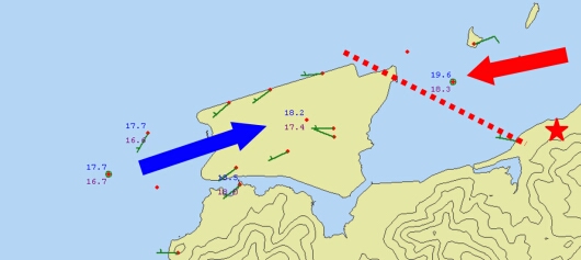
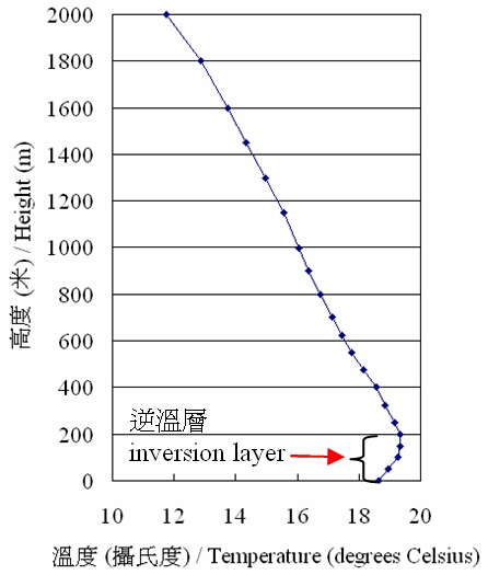
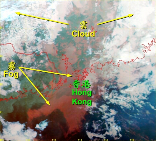
In the early hours of 7 March 2006, the coast of Guangdong was shrouded in dense fog brought in by a moist maritime airstream. At 00:50 a.m., an aircraft about to land on the Hong Kong International Airport had to go around due to low visibility. At that time, the visibility at Chek Lap Kok reached its lowest value that night of only 100 metres. The equipment of the Hong Kong Observatory unveilled some characteristics of the fog event. At the moment the visibility at Chek Lap Kok dropped to its lowest value, westerly winds prevailed over the airport and converged with the easterly winds coming from the east of the airport (Figure 1). At the convergence zone, the temperatures and dew points were about 2 degrees Celsius higher than those over the water to the west of the airport. It is believed that the dense fog formed from mixing of the two different air masses. The vertical temperature variation in the lower atmosphere at that time was favourable to dense fog formation. The Hong Kong Observatory installed a radiometer at Siu Ho Wan of Lantau Island (see location in Figure 1) for on-site testing. The equipment measures the vertical temperature variation based on detection of the radiation from oxygen in the air. At that time, the radiometer clearly indicated a layer of constant temperature from the ground up to a height of 150 metres. The layer of constant temperature later turned into a temperature inversion layer (i.e. temperature increases with height; Figure 2). These types of constant temperature and temperature inversion in the lower atmosphere are known to suppress vertical dispersion of fog and favour low visibility condition. Apart from ground equipment, meteorological satellites in the space also captured this occasion of dense fog. Sensors onboard the Earth Observing Satellites make observation of the Earth at night using infrared light. The Observatory received and processed images from one of these satellites. After processing, fog was depicted in a special colour (Figure 3), facilitating the monitoring of fog distribution. Low visibility weather affects the safety of both air and sea traffic. With the use of a variety of weather equipments, the Hong Kong Observatory tracks the location of fog nearby Hong Kong from all directions, aiding the forecasting of foggy weather. |
Figure 1 Ground level winds over the airport at 00:50 a.m., 7 March. Red dots indicate the locations of automatic weather stations. The figures to their upper left are the temperatures whereas the figures to their lower right are the dew point temperatures. The location of the radiometer is marked with a red star.
Figure 2 Temperature profile as measured by the radiometer at 1:22 a.m., 7 March.
Figure 3 Image captured by a Earth Observing Satellite of National Aeronautics and Space Administration, U.S.A. at 11 p.m., 6 March. Fog (in red) covered the Pearl River Delta and the neighbouring sea. |