More Specific Windshear Information on ATIS
|
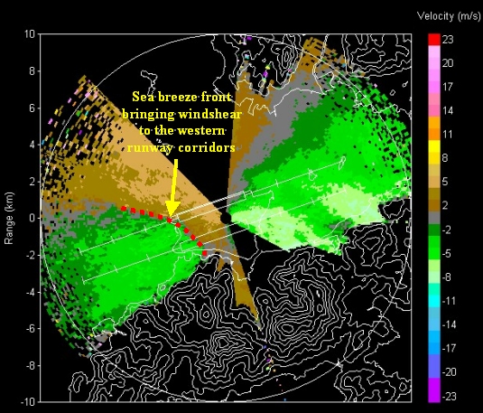
Commencing 27 January 2005, windshear warnings with more specific information are provided on the Automatic Terminal Information Service (ATIS) of the Hong Kong International Airport. First of all, windshear warnings on ATIS are now runway-specific, i.e. only the approach/departure corridors affected by windshear will be warned. Such warnings are desirable as the windshear observed at the airport sometimes only affects certain but not all corridors. One example is during the onset of sea breeze in mid-December 2004 as illustrated in the LIDAR (LIght Detection And Ranging System) imagery below – only the western corridors were affected by the sea breeze and hence would warrant the issuance of a warning only for the western corridors.
LIDAR imagery taken at 2:59 p.m. on 14 December 2004 Following the latest international standard, the windshear and turbulence warnings on ATIS will be given as 'FORECAST' when the information is based on meteorological assessment of the Observatory's forecaster. If the forecaster has been validated by pilot reports, the warning will be qualified as 'FORECAST AND REPORTED'. In response to users' request, the hill top wind on Lantau Island south of the airport will also be given in the arrival-ATIS as "2,500 ft estimated wind" when it reaches a speed of 35 knots or more. This is to help pilots get prepared for the possible wind changes expected on approach. It is expected that the more specific windshear information on ATIS could help instill users' confidence in the alerting service. Feedback from pilots and operators on the above changes are most welcome. They can be sent to the Hong Kong Civil Aviation Department (email: fsad@cad.gov.hk or fax: (852) 2362 4577), or to the Hong Kong Observatory (email: outreach@hko.gov.hk, fax: (852) 2375 2645). |