Operational Use of Automatic LIDAR Windshear Alerts
|
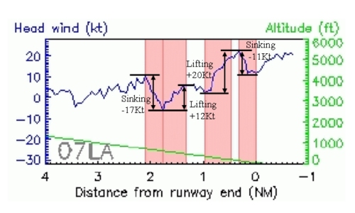
Later this month, the LIght Detection And Ranging (LIDAR) at the Hong Kong International Airport (HKIA) will start to provide automatic windshear alerts for operational use. The alerts will be made available on the Windshear and Turbulence Warning System (WTWS) for relay to the pilots by air traffic controllers. The LIDAR measures the speed of the wind using an eye-safe laser beam, similar to the laser gun of the police. However, instead of tracking speeding cars, the LIDAR follows the movement of tiny particles in the air. The LIDAR was introduced to HKIA in mid-2002 for airport weather alerting, the first of its kind in the world. Since 2002, the LIDAR has become a dispensable tool for aviation weather forecasters in warning windshear in non-rainy weather conditions. The automatic generation of LIDAR based windshear alerts starting this December is another step forward. Using a method developed in-house by HKO, LIDAR measurements along the glide paths of HKIA are analyzed to detect significant changes in the headwind and issue alert (see Figure). |
Figure - Headwinds (blue line) measured by the LIDAR during a windshear event along the glide path (07LA - approach corridor to north runway from the west in this case). The significant changes in headwind (marked by arrows) are successfully captured by the automatic windshear detection algorithm (highlighted in red). |