Satellite-based Convection Nowcasting Tool
|
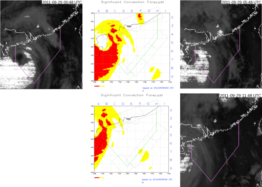
Extensive convective development over busy flight routes may disrupt air traffic. To facilitate air traffic flow management by the Air Traffic Control (ATC) in Hong Kong, the Observatory has been providing significant convection forecasts for key ATC areas within the Hong Kong Flight Information Region for trial use by ATC personnel since June 2010. A satellite convection cloud prediction system was developed to assist forecasters to fine tune the significant convection forecasts generated from NWP model outputs. The system produces forecast positions of deep convection cloud clusters at hourly intervals up to 12 hours ahead by using multi-grid optical flow method and advection technique. Figure 1 shows the satellite-based deep convection forecast for the case of Typhoon Nesat in 2011. |
|
Figure 1 6-hour forecast (upper middle) and 12-hour forecast (lower middle) of convective cloud clusters generated by HKO's satellite convection cloud prediction system based on the deep convection satellite image at 00 UTC on 29 September 2011 (left) when Typhoon Nesat was moving across the northern part of the South China Sea. The red regions represent deep convection in the forecast. On the right are the corresponding actual satellite images where deep convection is shown in bright white. |