Wind Distribution over the Hong Kong International Airport (HKIA) under Strong Northerly Winds associated with Tropical Cyclones
|
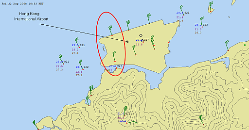
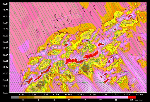
Under the strong northerly winds associated with tropical cyclones, the wind distribution over HKIA could be uneven at times. Winds over the north runway could be generally stronger than those over the south runway. During the approach of Typhoon Nuri in August 2008, winds over the north runway were stronger by 10–16 knots (i.e. 19–30 kilometres/hour) than the south runway in the western part of the airport (Figure 1). As the crosswind over the north runway was too strong at the time, aircrafts could only land at the south runway from the west. However, the airflow was actually rather turbulent over the south runway which made landing difficult. The Observatory uses a high-resolution numerical weather prediction model to study how Lantau Island affects the wind distribution over HKIA. Figure 2 shows the situation under strong northerly winds associated with Typhoon Nuri. The model successfully simulates that, over the western part of the airport, the winds at the north runway could be stronger than those at the south runway by about 10 knots, which is consistent with the actual observations. It is apparent that the terrain of Lautau Island has an impact on the wind distribution over HKIA in strong northerly winds. Besides, the buildings over the airport may also cause uneven wind distribution. The Observatory collaborates with the Department of Mechanical Engineering of the University of Hong Kong to study the uneven wind distribution arising from buildings in typical strong wind conditions associated with tropical cyclones using high-resolution computational fluid dynamics model. Preliminary modelling result shows that the wind difference could be as high as 15 knots (about 28 kilometres/hour) between the areas upstream and downstream of a building. To gain a more complete picture and understanding of the factors contributing to the uneven wind distribution over HKIA, it would be necessary to consider both the terrain in the vicinity of the airport and the buildings on the airfield in a single model, which belongs to the frontier of numerical simulation study. |
Fig.1: Wind distribution inside and around HKIA at 10:33 a.m., 22 August 2008. The wind speed on the western side of the north runway was about 10 knots higher than that on the south runway (indicated by red ellipse). |
Fig.2: Distribution of wind speed near the ground (colour contours)at and around the airport in the morning of 22 August 2008 as simulated by a high-resolution numerical weather prediction model. |