A New Paradigm for World Area Forecast System
|
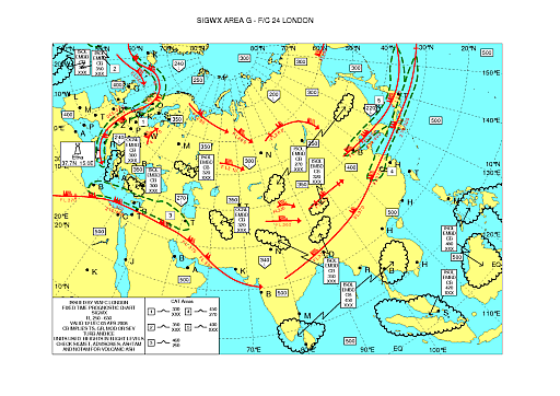
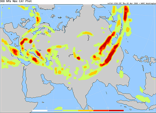
Mr. C.M. Shun, Acting Assistant Director of the Hong Kong Observatory, attended the 4th Meeting of the World Area Forecast System Operations Group of the International Civil Aviation Organization (ICAO) in Cairo, Egypt during 26 to 28 February 2008. The World Area Forecast System (WAFS) is a global system of aviation meteorological service set up by ICAO and the World Meteorological Organization (WMO). It aims to provide every aircraft with Flight Document to enable pilots to plan their flight routes, the flight time, the fuel needed and the maximum aircraft loading. Hitherto, the High Level Significant Weather Chart provided by WAFS (Fig. 1) has been indispensable for pilots in flight planning. Significant weather such as tropical cyclone, volcanic ash, jet stream and turbulence are clearly depicted on the chart. In the meeting in Cairo, ICAO proposed to replace the weather chart prepared by forecasters with the three dimensional gridded data (such as probability of clear air turbulence, Fig. 2) generated by numerical weather prediction model from computer. While the reform has the benefit of allowing airlines to make use of the weather forecasts generated by the more objective and sophisticated numerical method to enable automatic flight planning and to gain cost-effectiveness, there are still many problems to be solved. For example, how to present the large volume of computer-generated data to pilots to aid their pre-flight and in-flight decision arising from change in weather to ensure flight safety? This proposed change will have a great and long term impact on aviation weather service. In Cairo, Mr. Shun and the representative of China, with support from other members, put forward suggestions, hoping that after detailed studies and review, will gain general support for inplementation, resulting in a more effective and safe aviation meteorological services for the world. |
Fig.1: The High Level Significant Weather Chart currently provided to airlines and pilots. (SIGWX features all at a glance - including tropical cyclone, volcanic ash, radioactive cloud, squall line and duststorm/sandstorm). |
Fig.2: A newly developed forecast of clear air turbulence at 30,000 feet based on outputs of numercial weather prediction model. |