Using Dedicated LIDARs to Enhance Windshear Alerting at the Airport
|
In late 2006, the Observatory installed a LIDAR at the northern fire station which is the second unit at the Hong Kong International Airport (HKIA). This second LIDAR, being closer to the north runway than the first one, is used specifically to monitor the windshear condition over this runway. In the past spring, most of the aircraft landed at the north runway of HKIA from the west, viz. the 07LA runway corridor. Compared to the first LIDAR, the second unit was found to provide more accurate windshear alerts for the 07LA corridor; the alert duration was reduced by 11% and the hit rate of pilot windshear reports reached a higher value, fulfilling the original expectations. The result shows that the use of runway-dedicated LIDARs could enhance the alerting of windshear at the airport. The Observatory plans to move the first LIDAR to a location closer to the south runway to enhance the monitoring of windshear for departing flights. The related work is expected to take place in late 2007/early 2008. | ||||
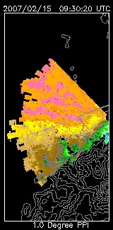
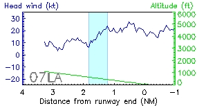
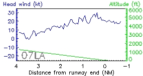
The upper and the lower panels on the right hand side of the figure show respectively the headwind profiles measured by the second and the first LIDAR at 17:35 H (09:35 UTC), 15 February 2007 over the 07LA runway corridor. The second LIDAR successfully captured the windshear (highlighted in blue), consistent with the pilot report. The left hand side of the figure gives the LIDAR velocity image at that time, with different colour shadings for the wind speed. It clearly depicts the wind variations over the 07LA corridor. |