Gust-front windshear observed by LIDAR (October 2003)
|
In the evening of 4 August 2003, a gust front crossed the Hong Kong International Airport, bringing windshear of 40 knots (75 km/h) as reported by a landing aircraft. However, wind measurements on the airfield only indicated a 20-25 knots (38-47 km/h) windshear. Why was that? Before finding a reason, let's first look at what a gust front is and the weather that day. A gust front is the leading edge of cooler air which rushed down and then spread out from a thunderstorm. An aircraft flying through it may encounter increased headwind and lift, resulting in windshear (Figure 1). Shortly before 8 p.m., a gust front swept across the airport from the east and reached the waters to the west, bringing with it strong northeasterly winds. Convergence of the northeasterlies with the background southwesterlies resulted in a headwind change of 20-25 knots as estimated from airfield winds (Figure 2). As the gust front carried little rain, the Observatory's LIDAR (LIght Detection And Ranging) system was very suitable for elucidating the wind pattern aloft, i.e. the winds as experienced by an approaching aircraft. Specifically, a near-horizontal LIDAR scan showed significant windshear across the gust front (Figure 3). LIDAR data aligned closely to the flight path was particularly revealing - indicating a windshear of some 37 knots (69 km/h) between 900 ft (270 m) and 600 ft (180 m) (Figure 4). This was close to what the aircraft pilot observed. LIDAR data is currently used by the aviation forecaster in day-to-day windshear alerting. In this gust front case a windshear alert by the forecaster gave 20 minutes of forewarning prior to the first aircraft reporting encounter of windshear that day. |
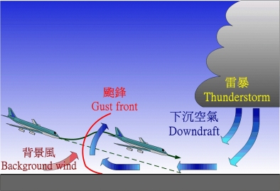
Figure 1: Schematic diagram of a gust front
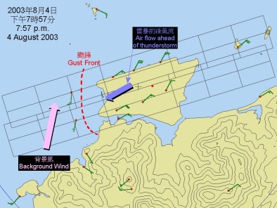
Figure 2: Winds around the airport at 7:57 p.m., 4 August 2003
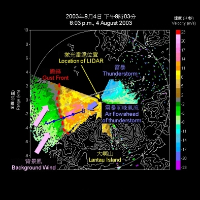
Figure 3: LIDAR image taken at 8:03 p.m., 4 August 2003
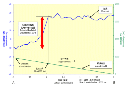
Figure 4: Headwind between points A and B (see Figure 3), as estimated from LIDAR data