Cloud Corner
|
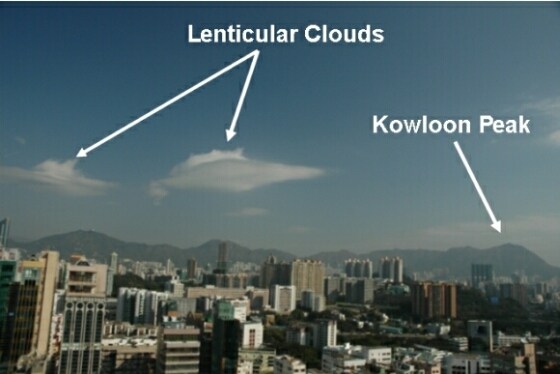
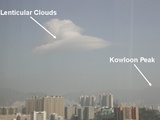
The cloud photograph below was taken on 8 February this year near the Observatory's Headquarters in the urban areas of Hong Kong. These “lenticular clouds” resemble a pair of “flying saucers”. They form when a layer of relatively stable and moist air-stream is forced to rise by hills, causing up and down wave motions in the air. The rising air in the wave causes the moisture to cool down and condense into water droplets, which then become visible to the eye. Since lenticular clouds look like one or more convex lens, they could sometimes be misinterpreted as flying saucers or Unidentified Flying Objects, and so they are commonly known as “flying saucer clouds”. Since the wave motions which bring the “flying saucer clouds” are caused by hills, these clouds would appear more readily in mountainous areas. In Hong Kong, “flying saucer clouds” do not appear frequently but their appearance over Kowloon on 8 February was not the first time. Similar cloud photo was taken by another HKO colleague in the morning of 9 January 2004 (see the second photograph below). The weather conditions on these two days were rather similar, with moderate to fresh easterly winds blowing near the surface and over the hills, and a rather stable atmosphere. We may therefore infer that the “flying saucer clouds” were caused by easterly winds blowing across the mountain Kowloon Peak and the nearby hills. In the future, if everybody pay more attention to the wind changes, one may have the chance to get a glimpse of the fascinating “flying saucer clouds”! |
Fig.1: “Flying saucer clouds” at 10 a.m. on 8 February this year (courtesy of Mr. C.M. Shun)
Fig. 2: “Flying saucer cloud” in the morning of 9 January 2004 (courtesy of Mr. C.M. Cheng) |