World-wide coverage of satellite imageries
|
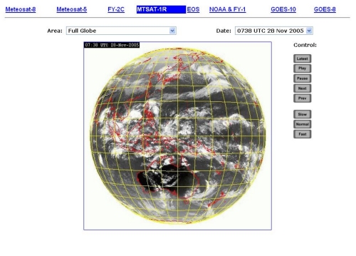
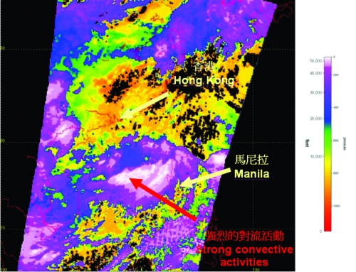
With the availability of the satellite images from the Chinese Fengyun-2C satellite and the Multi-functional Transport Satellite-1R (MTSAT-1R) of Japan Meteorological Agency, high-resolution images from these satellites have been made available on AMIDS since July 2005, to replace the images from the aging US Geostationary Operational Satellite-9 (GOES-9). The new satellite images cover regions in the eastern hemisphere (Fig. 1). In response to airlines' request for satellite images of the other parts of the world, satellite images from Meteosat-8 geostationary satellite of the European Organization for the Exploitation of Meteorological Satellites (EUMETSAT) and GOES-8 of the U.S. National Oceanic and Atmospheric Administration have also been added to AMIDS recently. These images cover the European and American regions. Together with the other satellite images, there is now a world-wide coverage of satellite images on AMIDS. Furthermore, to provide more information to the pilots and those involved in flight planning, cloud-top height images prepared from data of the Earth Observing System (EOS) satellites has also been launched on AMIDS. Users could get an idea of the heights of the cloud tops from the different colours on the images (Fig. 2). |
Fig. 1 MTSAT-1R full-disk image at 0738 UTC on 28 November 2005. A menu is available above the image to facilitate the user to select images for satellites over the other parts of the world.
Fig. 2 Cloud-top height image prepared from data of the EOS satellites at 11 a.m. on 10 June 2005 |