Meteorological Satellite Ground Reception System
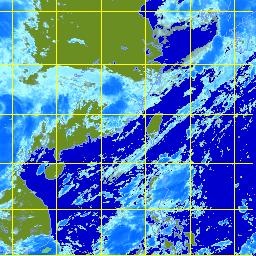
The Hong Kong Observatory operates a Meteorological Satellite Ground Reception System to receive high-resolution satellite signals from the Geostationary Meteorological Satellite (GMS) launched by Japan. Located above the longitude of 140 E, the GMS surveys the Eastern Hemisphere every hour. Images from infrared, visible and water vapor channels of the GMS are made available to workstations at the Airport Meteorological Office through dedicated data lines. The Meteorological Satellite Ground Reception System receives images from the Chinese Fengyun-2 geostationary meteorological satellite as well. The Fengyun-2 satellite is located above the longitude of 105 E, giving a good view of the Indian Ocean and western Asia. This helps the forecasters better monitor the weather systems to the west of Hong Kong. |
A sample of infra-red satellite imagery (The cloud imagery was originally captured by GMS of Japan Meteorological Agency) |