High Water Level due to Combined Effect of the Northeast Monsoon and Spring Tide
8 January 2026
Leo WK Cheung, Nathan YC WongIn the last couple of months, there were multiple occurrences of high water level due to the combined effect of the northeast monsoon and spring tide, which caused minor flooding in certain low-lying coastal areas in Hong Kong, including Tai O and the riverside along Shing Mun River and Tai Po (Figure 1). Such monsoon-related flooding is generally less severe than storm surges associated with tropical cyclones. Still, they may bring inconvenience to the public such as closure of those affected pedestrian subways or impacts to those residents and businesses in low-lying coastal areas.
In late December 2025, the Hong Kong Observatory launched “Coastal Sea Level (Trial)” webpage for the public. It shows total water level forecast at various tide gauge locations taking into account the anomalies brought about by meteorological factors such as monsoons or storm surges in addition to the astronomical tide. Members of the public can make reference to the forecast to get prepared for high water level and possible minor flooding in low-lying coastal areas.
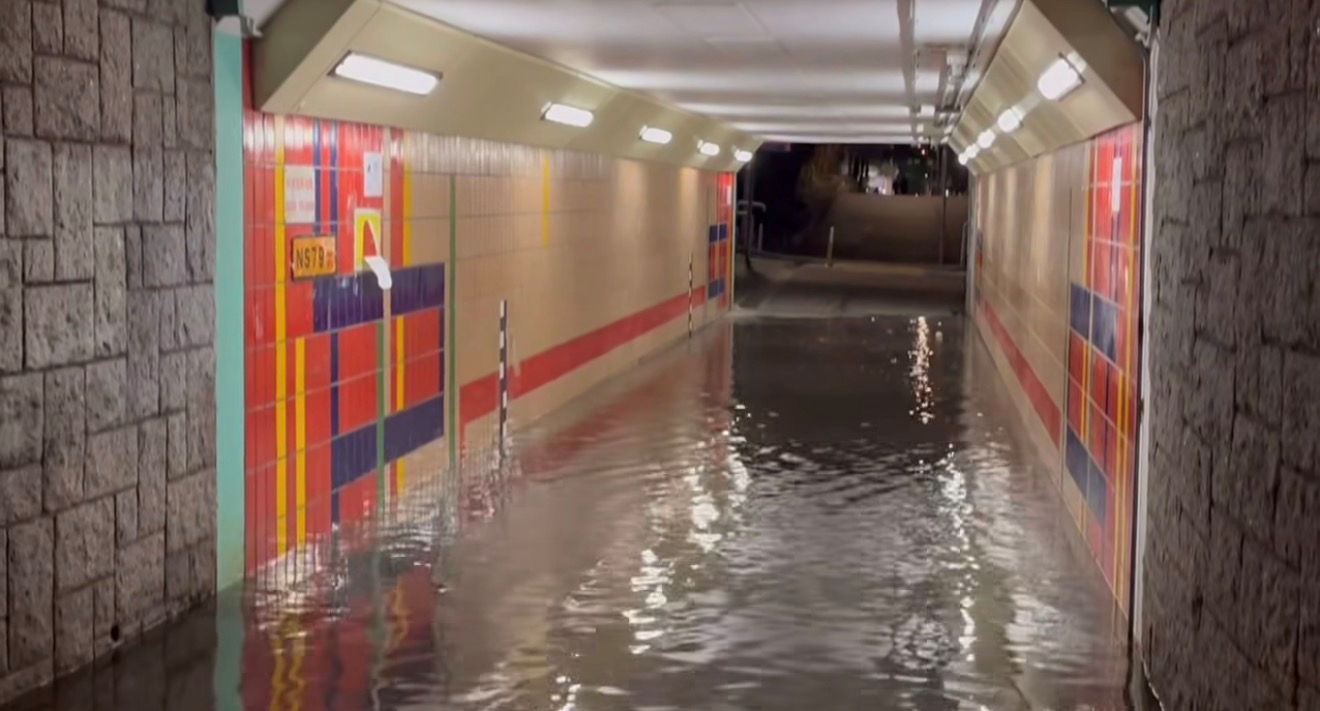
Figure 1. Minor flooding in one of the subways over Tai Po on the night of 2 January 2026.
(Photo courtesy of Mr Arthur Lee)
(Photo courtesy of Mr Arthur Lee)
When Northeast Monsoon Meets High Tides
In cool seasons, the northeast monsoon may bring persistent and high northeasterly winds to the coastal waters of southeastern China. When strong winds blow steadily over the seas, they transfer momentum to the sea surface and drive surface currents. The Earth’s rotation causes this wind-driven motion of seawater to change direction. Under the influence of the northeast monsoon, more water will then be driven towards the coast of southeastern China by high winds over the coastal waters and pile up over there (Figure 2).
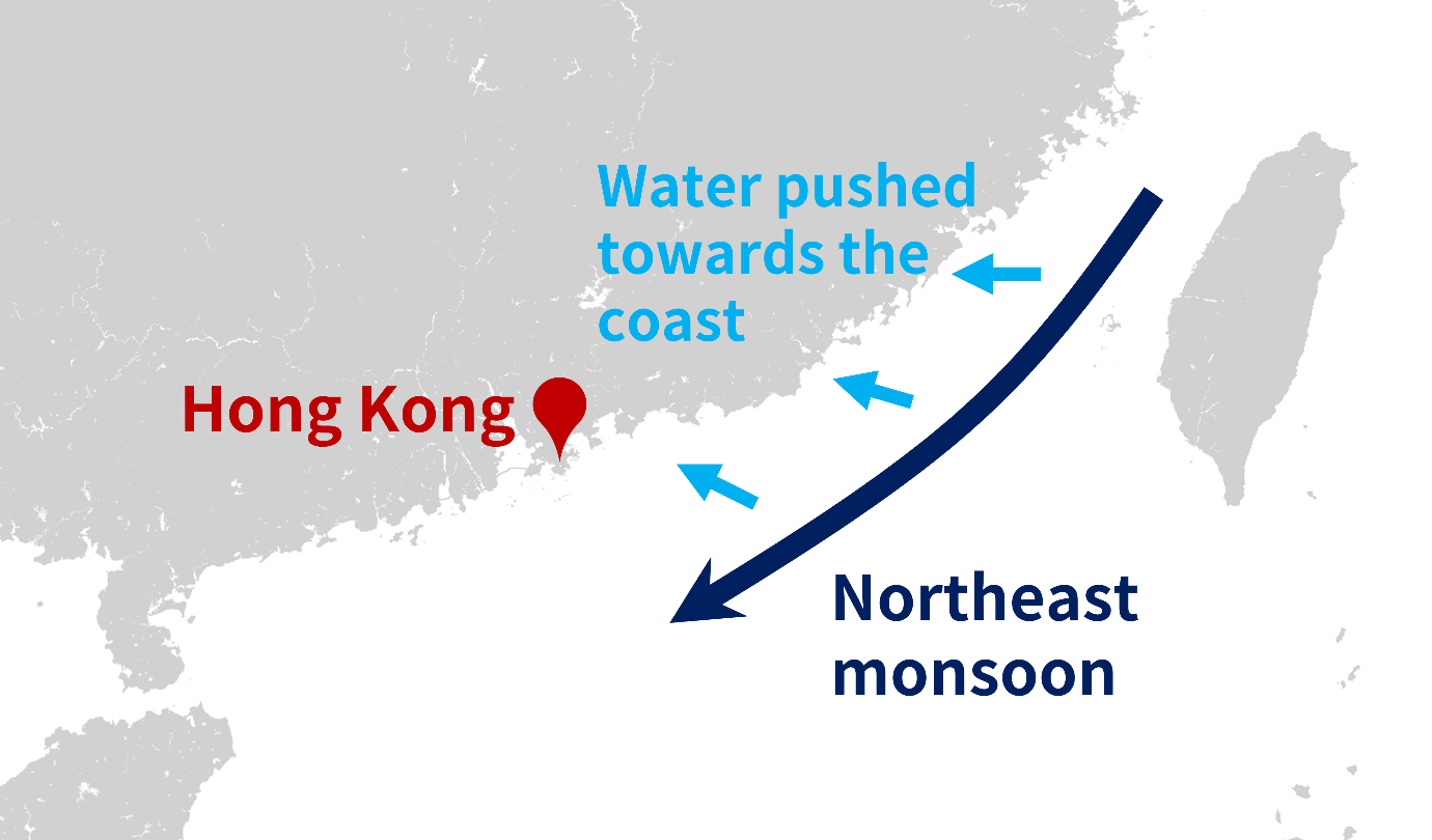
Figure 2. Along the southeastern China coast during northeast monsoon conditions,
seawater is pushed towards the coast and piles up over the coastal region.
seawater is pushed towards the coast and piles up over the coastal region.
On the other hand, spring tides occur around new moon and full moon. During spring tides, the tidal range is larger and high tides are higher than normal (low tides are also lower). If it so happens that a strong northeast monsoon is affecting the region, the extra water pushed towards the coast may result in even higher water levels around the time of high tides, sometimes high enough to cause flooding along parts of the coast.
Case example on 2 and 3 January 2026
The high water event on 2 and 3 January 2026 was an example (Figure 3). The astronomical high tide was already high due to the spring tide. With the northeast monsoon prevailing over southeastern China, the water level at Tai Po Kau reached 3.08 m above Chart Datum on the nights of 2 and 3 January, causing minor flooding along parts of the riverside of the Shing Mun River and in Tai Po. High water levels were also recorded in other areas, such as Tai O where the highest water level on the night of 3 January reached 3.05 m above Chart Datum.
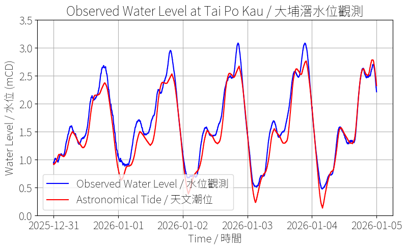
Figure 3: Observed water level (blue line) and the astronomical tide prediction (red line) at Tai Po Kau tide gauge
between 31 December 2025 and 5 January 2026.
The difference between reflects the water level anomalies due to the northeast monsoon.
between 31 December 2025 and 5 January 2026.
The difference between reflects the water level anomalies due to the northeast monsoon.
The Observatory uses various forecasting techniques to predict high water levels due to the combined effect of meteorological factors and spring tides, including hydrodynamic models, past case analogy, and making reference to the observed water level changes along the coast of southeastern China. Hydrodynamic model simulates how winds drive sea currents and raise sea level based on wind forecast from numerical weather prediction model. The Observatory has been keeping close contact with other relevant departments regarding potential high water level episodes. When water level is forecast to reach alert threshold that may cause flooding over the low-lying coastal areas, advance notification will be sent to them to facilitate their necessary early preparation. Members of the public can refer to the “Coastal Sea Level (Trial)” webpage to obtain the total water level forecast for the next 12 hours, together with a likely range of the prediction indicating the forecast uncertainty. The information can facilitate the public in planning for coastal activities near the shore or taking appropriate precautionary measures in advance if there is a risk of seawater inundation associated with high water level forecast.