Myanmar M7.6 Earthquake on 28 March 2025
29 March 2025
CHAN Yuk-po Bowie, CHAN Wai-soen, HUI Tai-wai
According to the analysis by the Hong Kong Observatory, a major earthquake struck Myanmar at 2:20 p.m. Hong Kong time on 28 March 2025. The initial analysis rated it at M7.3, and was later updated to M7.6. It was a shallow earthquake with a focal depth of around 10 km. The epicentre was located approximately 85 km north of Meiktila, about 1,880 km west of Hong Kong. Approximately 12 minutes after the mainshock, a strong aftershock of M6.9 struck near the epicentre, with the final revision of the focal depth at 30 km.
The main damage and casualties from this shallow major earthquake occurred in Myanmar, but even in Bangkok, Thailand which is over 800 km away from the epicentre, an under-construction high-rise building collapsed. According to literature studies [1, 2, 3], some researchers pointed out that the geological conditions of Bangkok may cause site effects, amplifying the shaking caused by seismic waves. Additionally, other factors such as resonance effect could be at play. The underlying causes and relationships still require further study and investigation by local and other experts.
This M7.6 earthquake occurred along a strike-slip fault in central Myanmar (Figures 1 and 2). The Observatory's seismometers detected seismic waves generated by this M7.6 event in Myanmar. Through real-time analysis of global and local seismometer data, the Observatory's earthquake data processing system calculated the earthquake parameters, including the origin time, epicentre, focal depth and magnitude. Figure 3 shows the seismic waveform recorded by the broadband seismic station at Po Shan of Hong Kong. Since the earthquake was distant from Hong Kong, it was not locally felt.
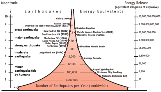
Major earthquakes generally occur more frequently at plate boundaries (Figure 4). Myanmar lies within the Alpine-Himalayan seismic belt, close to four tectonic plates, namely the Indian Plate, Eurasian Plate, Burma Plate, and Sunda Plate. This forms a complex fault system (Figure 5), making the area one of the most seismically active regions in the world. The recent major earthquake was primarily caused by a sudden fault displacement along the Sagaing Fault, Myanmar's largest and most active strike-slip fault[4], which released a significant amount of strain energy. Historically, this area has experienced multiple earthquakes of magnitude 7 or above (Figure 6). According to the records of the United States Geological Survey (USGS), there were 72 earthquakes with magnitude 6.0 or above occurred within 500 km of this epicentre since 1905, with the largest one being the M7.9 earthquake on 23 May 1912 (Figure 7). Along the Sagaing Fault, the previous earthquake with M7.5 or above was the M7.6 Myanmar earthquake in 1946. The frequency of earthquakes decreases as magnitude increases. Nearly twenty earthquakes of M7.0 or above occur globally each year on average (Figure 8). The most recent major earthquake prior to this was a M7.5 event off the coast of Montego Bay near Central America, on 9 February 2025.
When the Observatory detects an earthquake with M6.0 or above in any parts of the world, it will issue a strong earthquake report to the public through multiple channels (including the Observatory’s website, the “MyObservatory” mobile application, social media platforms, and the Government News and Media Information System). For earthquakes with M5.0 or above, the Observatory will also issue Quick Earthquake Messages through its mobile application, website and social media platforms. The Observatory will also update earthquake parameters and release on the Observatory's website and its mobile application when situation warrants.
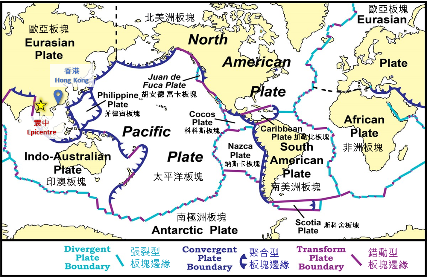 Figure 1 Diagram showing the global distribution of tectonic plates. The yellow star marks the epicentre of the Myanmar M7.6 earthquake on 28 March 2025. (Base map modified from United States National Park Service [5])
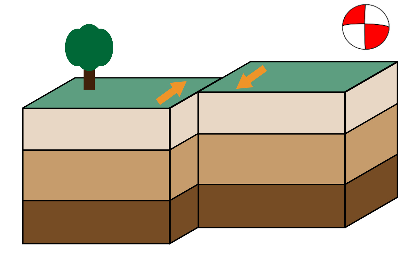
Figure 2 Focal mechanism based on the HKO’s analysis (“beachball” graphics at top right) and the faulting motion associated with the M7.6 Myanmar earthquake. (Modified from USGS [6])
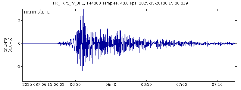
Figure 3 Seismic waveform recorded by the broadband seismograph at Hong Kong Po Shan station (around 1,880 km east of the Myanmar earthquake’s epicentre). The P-wave arrived at the seismometer at 06:25 UTC (HKT = UTC + 8) on 28 March 2025, around 5 minutes after the occurrence of the earthquake.
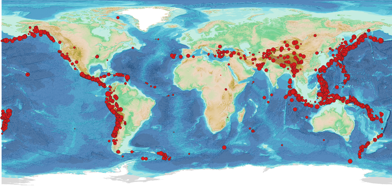
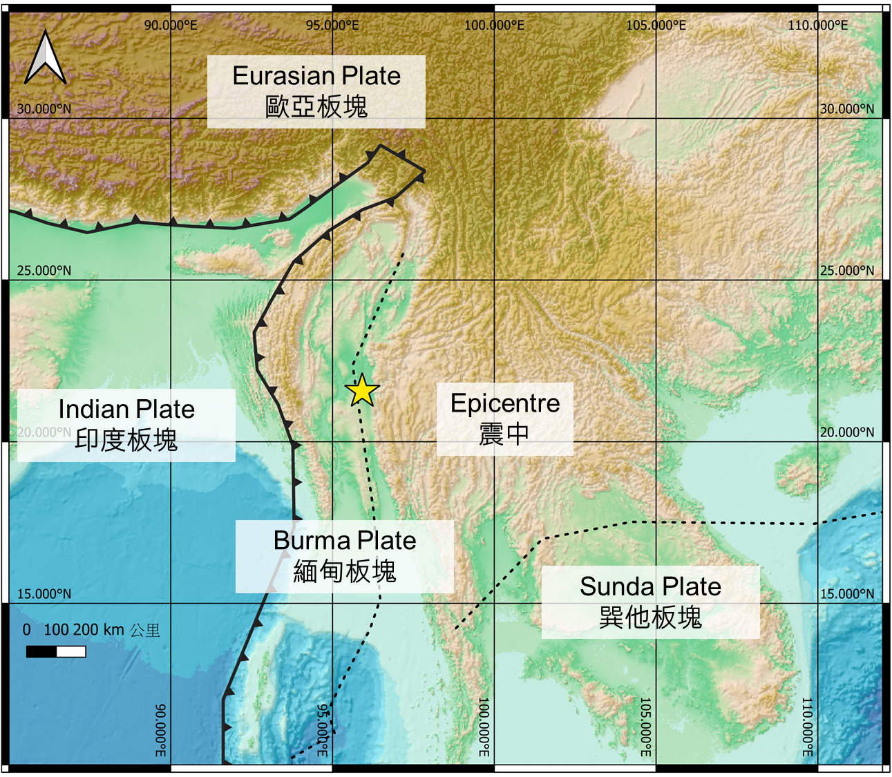

Figure 6 Epicentres of earthquakes of M7.0 or above occurred along the Sagaing Fault since 1905 (black dots) based on USGS records [7], and the epicentre (yellow star) of this Myanmar M7.6 event.

References:
[1] Tuladhar, R. et al. Seismic microzonation of the greater Bangkok area using microtremor observation, Earthquake Engineering Engng Struct. Dyn. 2004, 33, 211-225.
[2] Ornthammarath T. et al. Preliminary analysis of amplified ground motion in Bangkok basin using HVSR curves from recent moderate to large earthquakes 2023, Geoenviron Disasters 10, 28
[3] Poovarodom, N. and Jirasakjamroonsri, A. Seismic site effects of soil amplifications in Bangkok. Thammasat International Journal of Science and Technology 2016, 21, 3
[4] Xiong, X., et al. Coulomb stress transfer and accumulation on the Sagaing Fault, Myanmar, over the past 110 years and its implications for seismic hazard. Geophysical Research Letters 2017, 44, 10, 4781-4789.
[5] National Park Service: Evidence of Plate Motions
[6] USGS Geological Survey: What is a fault and what are the different types?
[7] United States Geological Survey (USGS): Earthquake Catalog
[8] EarthScope: How Often Do Earthquake Occur?
[9] HKO: How to Interpret Seismic Parameters?