Snowstorm in South Korea between 26 and 28 November 2024
9 December 2024
LAO Wing-kwan, NG Yin-lam, TSE Wai-po
At the transitions from autumn to winter, an intense northeast monsoon gradually affected east Asia continent and spread south in late November. While the weather became cool in Hong Kong, the process of cold air activity had a more significant impact in the mid-to-high latitude areas. Apart from being the first cold surge in the mainland in the second half of this year, it also brought a record-breaking snowstorm to Seoul, South Korea and its surrounding areas. The Seoul Meteorological Observatory recorded a snow depth of 28.6 centimetres between 26 and 28 November, the deepest record for November since 1907.
Causes of the snowstorm
Analysis information (Figure 1, left) depicted the establishment of a cut-off low [1] pressure system near 120°E to 140°E (in the vicinity of the northeast Asia continent) in late November. As the system remained stationary over northeastern China for a couple of days, the associated upper-air westerly waves continuously transported cold air from the north to the vicinity of the Bohai Sea and the Yellow Sea (Figure 1, right). In addition, the sea surface temperature of the region was about 2 degrees higher than the climatological normal (Figure 2), which increased the water vapor content of the near-surface air mass. When the warm and moist air mass met the cold and dry air from the north, the usually large differences in temperature and humidity coupled with the updraft mechanism driven by the upper-air westerly waves, provided ideal conditions for cloud development. Eventually, these clouds were carried by upper-air westerlies to the vicinity of the Korean Peninsula (Figure 1, right) continuously, causing a large amount of snowfall under suitable physical conditions.
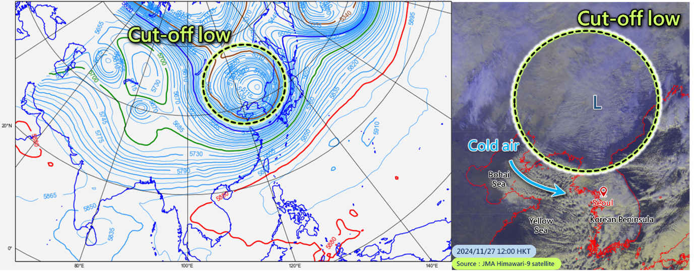
Figure 1 (left) - ECMWF analysis information of 500 hPa geopotential height at 8 a.m. on 27 November (HKT) depicting the establishment of a cut-off low pressure system between 120°E and 140°E
Figure 1 (right) - Satellite image at noon on 27 November (HKT) showing a broad band of clouds moving towards the vicinity of the Korean Peninsula from the Bohai Sea and the Yellow Sea under the steering of upper-air westerlies
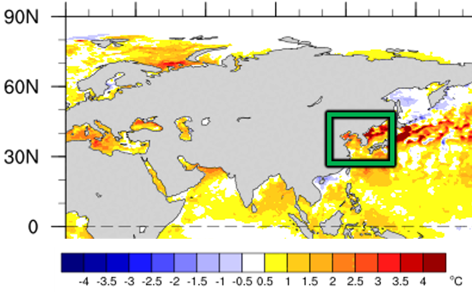
Figure 2 – Green box indicating the sea surface temperature anomaly in the seas near the Korean Peninsula (24 to 30 November).
Source: National Oceanic and Atmospheric Administration
Impact on aviation
Moderate snowfall may bring beautiful scenery, but heavy snowstorms will cause impacts on the society and people's livelihood. According to the official information from the South Korea, the heavy snowstorm seriously affected the operations of airports. For example, the snow depths at Incheon International Airport and Gimpo International Airport exceeded 15 centimetres on 27 November. On 27 and 28 November, a total of 356 flights were cancelled and 1,490 flights were delayed at Incheon International Airport. There were 1,033 flight cancellations and 4,352 flight delays at the two major international airports in Seoul (Incheon International Airport and Gimpo International Airport) during the same period.
Heavy snow piling up on runways or aircraft is the major cause of flight delays and cancellations. When runways are covered with heavy snow, they may need to be temporarily closed for snow removal since snow accumulation affects the friction between aircraft's tires and the runway, increasing the risk of aircraft takeoffs and landings. In addition, when there is snow on aircraft, the air flow over the aircraft's body and wings will be disrupted, making it impossible for the aircraft to gain enough lift for takeoff. The aircraft needs to be deiced by spraying anti-icing agents to remove the ice or semi-frozen moisture from the aircraft surface. It can also reduce the freezing point of moisture that contacts the aircraft surface, preventing the formation of new ice. However, the effective time of deicing agents will still be limited by the amount of snowfall. Moreover, heavy snow usually reduces visibility. To ensure safety, air traffic control authorities may increase aircraft spacing and lengthen the time interval between takeoffs and landings, causing some flights to be cancelled or delayed.
In the context of climate change, anomalies in atmospheric or oceanic circulation may be exacerbated, making extreme weather more frequent and affecting the whole world. To alleviate global warming and its associated impacts, everybody should conserve resources, reduce waste, and take action in daily life for the betterment of the earth!
[1]: A cut-off low pressure system is a slow-moving or almost stationary large-scale weather system that blocks the normal eastward progression of upper-air trough-ridge disturbances, leading to prolonged periods of extreme weather conditions.